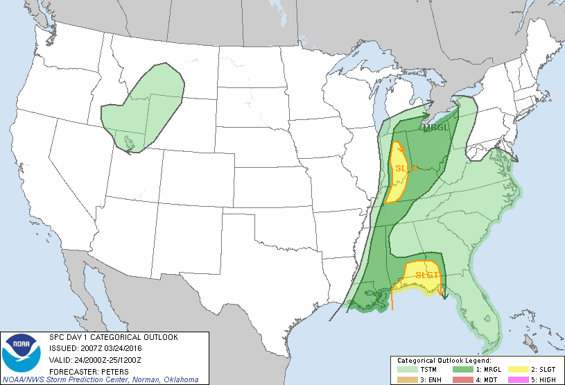
The latest from the Storm Prediction Center has dropped much of Alabama from the slight risk of severe weather for the remainder of today. The slight risk is still in effect for much of extreme southern Alabama, including the Alabama Gulf Coast, Troy, Dothan, Enterprise, and Geneva. Only a small strip of north and central Alabama along the AL/MS border is in a marginal risk for severe weather throughout the remainder of tonight. Much of south Alabama is in a marginal risk area, except for the slight risk areas. Even though much of central Alabama has been removed from the slight risk area, NWS Birmingham is still not convinced that the threat is over.

Published on: March 24, 2016 at 3:35 PM
Related Articles
November 4, 2026 at 2:54 PM
Rain Ends Tonight; Dry Days Ahead For Alabama
RADAR CHECK: Showers and a few thunderstorms are lined up across Alabama from near Scottsboro to Birmingham to Selma to Jackson at mid-afternoon. This is along a cold front which is moving eastward. With weakening wind fields and dynamic support, … Continue reading →
READ MORE
November 4, 2026 at 5:35 AM
Showers And A Few Storms Today; Drier Air Returns Tomorrow
RADAR CHECK: Large areas of rain and a few thunderstorms are moving through Alabama early this morning ahead of an upper trough and surface front. Additional showers will form this afternoon… we note SPC has defined a very low end … Continue reading →
READ MORE
