


Saturday brought one last taste of quiet fall weather across Alabama, with sunshine filtered at times by high clouds and comfortable afternoon temperatures in the mid 70s north to near 80 south. Light easterly breezes kept humidity low, and the day stayed dry statewide ahead of a more unsettled pattern expected to arrive Sunday.
ALABAMA THIS MORNING
Sunday morning is starting gray and breezy statewide as our next storm system edges in from the west. Light to moderate rain has spread into West Central and Southwest Alabama and will reach the I-65 corridor through the morning. Northeast and Southeast Alabama stay mainly dry early with showers arriving closer to late morning. Temperatures are cool to mild, in the 50s and 60s—with easterly winds 10–20 mph and occasional higher gusts. Thunder is limited overall, mainly back over southeastern Louisiana, but a few rumbles are possible near the Gulf Coast and far southwest Alabama. There could be a strong to severe storm near and south of a northward retreating warm front, generally south of US-84. The best chances are near the coast. Along the beaches, expect hazardous surf and a high rip current risk.
SPANN SKYWATCHERS
Most readings have been in the upper 50s to lower 60s this morning, with the usual cool suspects turning in middle 50s for their homework, looking at you Captain Cool: Vic Bell. Southern Skywatchers checked in with 60s. We really appreciate our Skywatcher Crew for their diligence getting up and turning in their reports.
ALABAMA WEATHER
Clouds and moisture are increasing across Alabama as a slow-moving storm system approaches from the west, marking the end of our recent dry stretch. Rain will spread across much of the state today and linger into the first part of the new week, followed by a noticeable cool-down late week.
RAIN ARRIVES TODAY
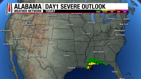
Showers will begin early in west Alabama and expand eastward through the morning, becoming steady statewide by afternoon. A few embedded thunderstorms are possible, mainly near the Gulf Coast where moisture and instability are highest. The SPC has a Marginal Risk for areas south of a line from Gilbertown in CHoctaw County to Monroeville to Evergreen to Florala. There is a level 2 out of 5 Slight Risk for areas south of I-10. Highs range from near 60 north to the lower and some middle 70s south, with gusty easterly winds 10–20 mph.
SHOWERS CONTINUE SUNDAY NIGHT
Rain becomes widespread overnight with locally heavy downpours, especially from US-84 north to the Tennessee line. A few stronger storms could occur near the warm front along coastal Alabama and the western Florida Panhandle. Temperatures hold steady in the 50s north and upper 50s to low 60s south, with breezy conditions continuing.
LINGERING RAIN MONDAY
Light to moderate rain persists through midday before tapering from west to east in the afternoon. Skies remain cloudy and cool with highs in the mid to upper 60s for central and southern counties, and lower 60s north. A few lingering showers may redevelop in the evening as another upper disturbance approaches.
TUESDAY THROUGH THURSDAY TURN COOLER
Another front brings scattered showers Tuesday night into Wednesday, followed by drier and much cooler air. Daytime highs fall into the 50s and low 60s with nighttime lows dipping into the 40s—some 30s possible in north Alabama by Thursday morning. The midweek pattern looks cloudy at times but mainly dry after Wednesday.
FRIDAY AND SATURDAY FEEL LIKE FALL
High pressure settles in to end the week, bringing crisp mornings and sunny afternoons. Expect highs in the 60s and lows in the upper 30s to lower 40s statewide, with frost possible in sheltered valleys up north. The weekend looks pleasant and seasonably cool with no rain expected.
DANCIN’ WITH THE STATS
For the third straight day, Brownsville and McAllen, Texas set record highs for the date again. On Saturday, both hit 95 degrees. They may break more records through Tuesday.
NATIONAL WEATHER
ATMOSPHERIC RIVER SLAMS THE NORTHWEST
A pair of Pacific storm systems will continue to drench the Pacific Northwest through Sunday, bringing heavy rain along the coast and hazardous snow to the Cascades and northern Rockies. Rainfall totals may exceed an inch at lower elevations, while mountain passes could see 4 to 12 inches of snow and dangerous travel conditions. The region stays cool into early next week as the upper trough lingers.
FLASH FLOOD AND SEVERE WEATHER THREAT IN THE GULF STATES
From east Texas to the central Gulf Coast, rounds of thunderstorms continue today and Sunday with the potential for flash flooding and isolated severe storms. The heaviest rain will fall across coastal Mississippi, Alabama, and the western Florida Panhandle, where storms may train or backbuild, producing rainfall rates of 1 to 3 inches per hour. SPC maintains a Marginal Risk and a separate Slight Risk along the Gulf Coast for severe storms on Sunday with damaging wind gusts and a brief tornado possible along the warm front.
COASTAL STORM TO SOAK THE SOUTHEAST
By Monday, a new low will form along the Southeast coast, spreading widespread rain and thunderstorms from Georgia to the Carolinas. Some areas could experience localized flash flooding, especially in the coastal plain. Meanwhile, the Northeast stays cool and mainly dry under high pressure, while much of the Southwest and southern Texas enjoy unseasonably warm afternoons with highs in the 80s to near 90.
TROPICS
As of Sunday morning, Hurricane Melissa is undergoing a period of extreme rapid intensification and is now a powerful Category 4 hurricane with sustained winds now near 140 mph. Satellite imagery shows a well-defined, compact eye and intense eyewall convection, classic signs of a storm undergoing explosive intensification. Melissa is drifting slowly westward in the Caribbean Sea and is expected to continue gaining strength today, likely reaching Category 5 intensity tonight before making landfall on Jamaica late Monday night or early Tuesday.
This is an extremely dangerous and life-threatening situation for Jamaica. The island faces a worst-case scenario with hurricane-force winds expected to last more than 36 hours, bringing catastrophic damage to structures, widespread power and communication failures, and a life-threatening storm surge along the southern coast. Torrential rain will also lead to devastating flash flooding and mudslides across the mountainous interior. Preparations on the island must now be complete — those in Jamaica should remain in secure shelter and be prepared to stay there through midweek. After crossing Jamaica, Melissa will move toward eastern Cuba and the southeastern Bahamas by Tuesday night, still as a major hurricane
BEACH
Beach conditions remain hazardous across the Alabama and northwest Florida coasts this Sunday, with a High Surf Advisory and High Rip Current Risk in effect through at least Monday afternoon. Surf heights of 4 to 6 feet and strong onshore winds around 20 mph will create dangerous conditions for swimmers and small craft. Periods of clouds and scattered showers, along with a few thunderstorms, will move in through the day as moisture increases ahead of an approaching front. Water temperatures are in the mid 70s, and highs will reach the upper 70s along the beaches, but anyone visiting the coast should avoid entering the water due to life-threatening rip currents and pounding surf.
WEATHERBRAINS
We will be talking Kentucky Weather on Monday night with two folks from the Kentucky Climatologist’s Office. Kentucky has had its share of wild weather over the years, and that will be a point of conversation, as well as their state mesonet, one of the most respected in the nation. WeatherBrains: the weekly netcast that’s all about weather. Get it wherever you get you podcast, or watch live Monday night on YouTube as we record the show! Visit the show’s website at www.weatherbrains.com.
HISTORY
On October 26, 2010, a powerful extratropical cyclone exploded over the Upper Midwest, producing record-setting barometric pressures and widespread severe weather. Bigfork, Minnesota, measured 955.2 millibars (28.21″), the state’s lowest on record, while Wisconsin also set a new low at 28.36″. Winds gusted up to 75 mph, toppling trees and vehicles, and heavy snow blanketed parts of Minnesota. The extreme pressure gradient extended far south, spawning 34 tornadoes from the Plains to the Southeast. In Alabama, several F0–F1 tornadoes touched down, including one in north Birmingham and another in DeKalb County that damaged homes near Whiton. Tragically, 60 mph winds in South Bend, Indiana, killed a Notre Dame student filming football practice, underscoring the storm’s immense reach and power.



