An all new edition of the ABC 33/40 Weather Xtreme video is available in the player on the right sidebar of the blog. You can subscribe to the Weather Xtreme video on iTunes by clicking here.
ANOTHER FREEZE AHEAD: Despite a brilliantly sunny sky, temperatures are a good 15 to 20 degrees below average across the great state of Alabama this afternoon; most places are in the 46-51 degree range. We note the air is very, very dry this afternoon… the dew point at Fort Payne at mid-afternoon was 3 degrees.
Once the sun goes down, temperatures will drop quickly, and we are looking at lows in the 21-29 degree range again early tomorrow morning.
Birmingham’s record low for tomorrow (November 14) is 24 degrees set in 1986… we will be very close to that level. Birmingham’s official low this morning turned out to be 24, within two degrees of the record low for today, 22 set in 1911.
WARMER DAYS: A warming trend begins tomorrow afternoon as we rise into the 50s with a sunny sky. Then, 60s are likely Friday afternoon.
Looks like we will need to introduce the risk of isolated showers Friday in a WAA (warm air advection) pattern; the GFS looks dry, but the 12Z NAM shows potential for a few scattered showers during the day.
WEEKEND OUTLOOK: Not much change in our thinking. Saturday will be generally dry with only isolated showers and a high around 70 degrees. Then, showers become likely Sunday afternoon as a cold front nears Alabama. Sunday will be a mild day with a high in the low 70s.
SPC has parts of Arkansas, Northwest Mississippi, and West Tennessee in a severe weather risk for Sunday (Day Five), but as the line of storms moves into Alabama Sunday night, they should weaken due to the lack of surface based instability. Looks like the main window for stronger storms will come from about 6:00 p.m. Sunday through 6:00 a.m. Monday.
See the Weather Xtreme video for the maps, graphics, and details.
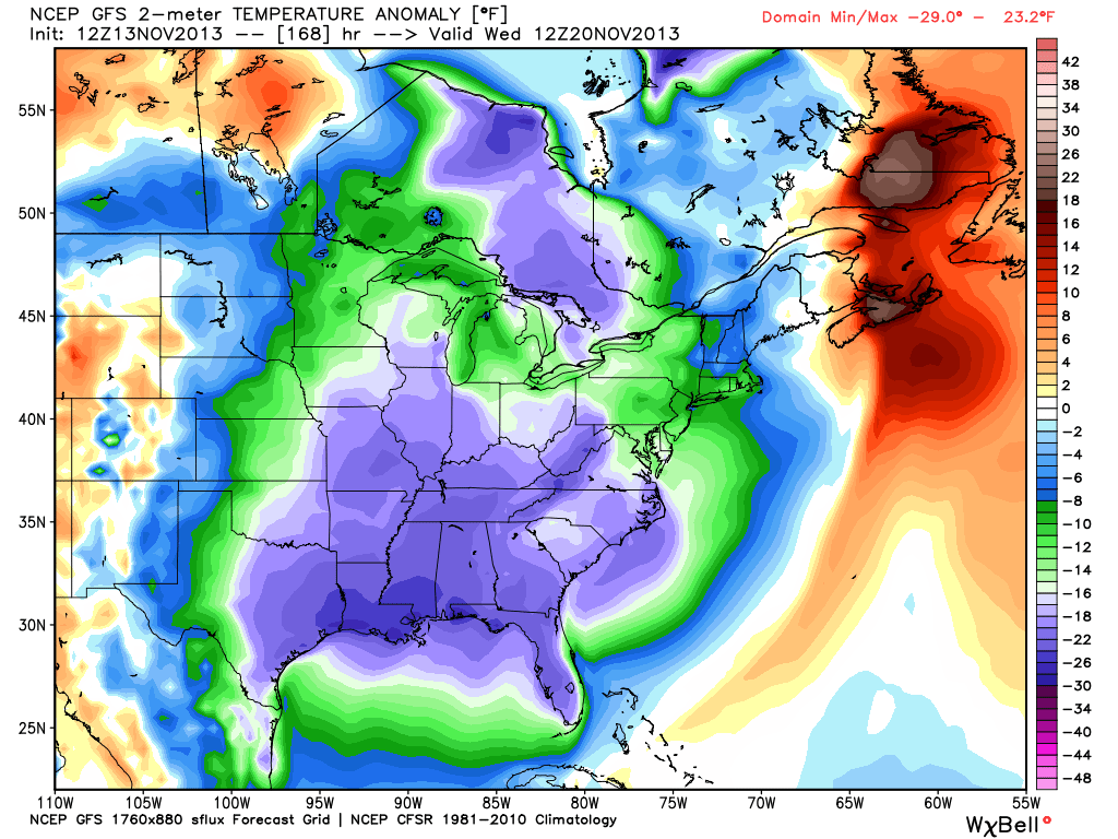
NEXT WEEK: A new surge of cold, dry air blows into Alabama Monday night and Tuesday. Doubtful we get out of the 40s Tuesday, and we go down into the 20s again by daybreak Wednesday. Here is a look at temperature anomalies expected early Wednesday (November 20)…
NEED YOUR WEATHER RADIO PROGRAMMED? We will be in Calhoun County at Downey Drug on U.S. 431 in Alexandria today from 3:30 until 6:30 p.m…. come see us. I will be there doing the weather live on ABC 33/40 at 4, 5, and 6:00.
WEATHER BRAINS: Don’t forget you can listen to our weekly 90 minute netcast anytime on the web, or on iTunes. This is the show all about weather featuring many familiar voices, including our meteorologists here at ABC 33/40.
CONNECT: You can find me on all of the major social networks…
Facebook
Twitter
Google Plus
Instagram
I had a great time today visiting with the kindergarten students at Striplin Elementary in Gadsden… they will be on the Pepsi KIDCAM tomorrow at 5:00 on ABC 33/40 News! The next Weather Xtreme video will be posted here by 7:00 a.m. tomorrow…