


Daily Weather Briefing
Saturday, May 9, 2026
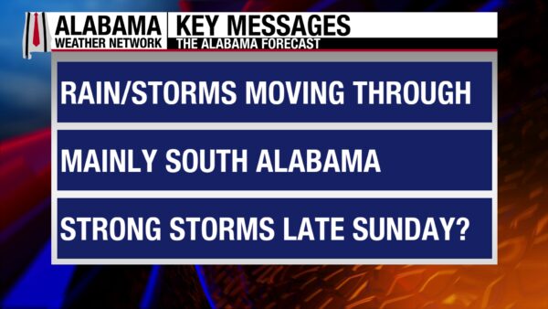
ALABAMA THIS MORNING
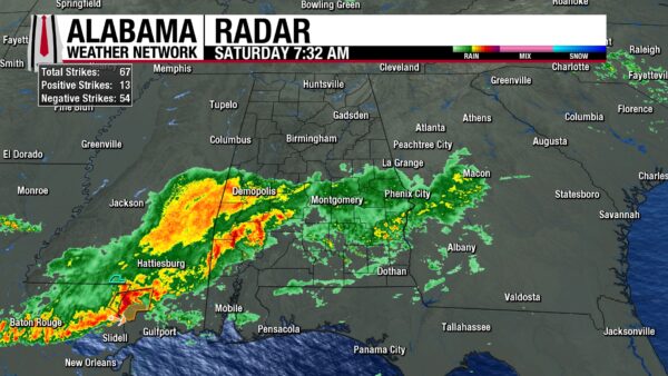
Early this morning, showers and sub-severe thunderstorms moved from south-central Mississippi into south-central Alabama. The storms featured a slightly southeastward track and continued through the morning. Additionally, more storms from southeast Mississippi have moved into the Coffeeville, Butler, Jackson, and Citronelle areas, and Mobile and Bay Minette can expect more widespread thunderstorms within the next hour. Showers and thunderstorms stretch all the way to the Alabama-Georgia line, while the northern half of the state is dry. Thick clouds blanket the state, and temperatures sit in the upper 50s to lower 60s north, and low to mid 60s across central and south Alabama.
ALABAMA 7 DAY FORECAST
Today will be mostly dry across the northern half of the state, while the southern half sees widespread showers and thunderstorms and a low chance of severe weather. The south holds onto its severe weather potential tomorrow as a cold front sweeps from north to south Sunday afternoon through Monday. A few thunderstorms ahead of the front are possible. Monday will be stormy until the front moves out of the state, then dry weather persists through Friday.
STORMY SOUTH AGAIN
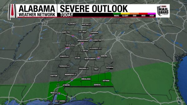
South-central/south Alabama will again be the star of the show today. A stationary front off the Gulf Coast brings showers and thunderstorms to the southern half of the state. Only the south is under a Marginal Risk (1/5) of Severe Thunderstorms, however. Damaging winds, hail, and frequent lightning are the main concerns with this system. Highs will sit in the mid to upper 70s. Gulf Shores will hit 80 degrees.
Meanwhile, in the northern half of Alabama, a few showers and thunderstorms are possible in the afternoon, but they will be isolated to scattered in nature. No severe weather is expected in the region. The day will be mostly cloudy, with a chance for some breaks in clouds in the afternoon. The upper 70s and lower 80s are what we’re expecting for our highs.
QUIET NORTH, RAIN SOUTH TONIGHT
The divide between a dry north and a wet south continues overnight, with low to medium chances of rain over the southern half of the state. The rain will come as showers and thunderstorms, but severe weather is mostly out of the question. A severe storm may develop here or there in the evening/early night hours. Lows will bottom out at the mid to upper 50s north, upper 50s to lower 60s centrally, and low to mid 60s south. The coast will stay in the upper 60s.
COLD FRONT SUNDAY
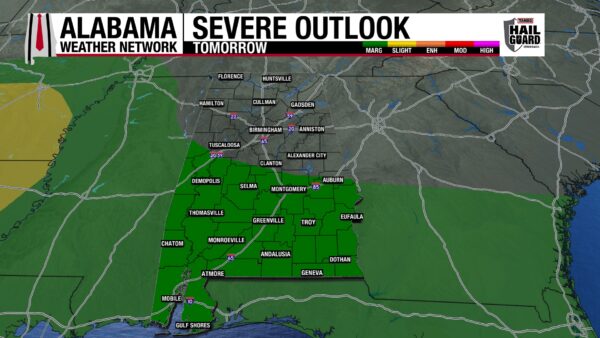
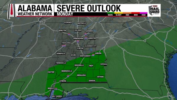
Most of the day Sunday will be relatively dry, with showers and thunderstorms possible ahead of the main front. Skies will be partly to mostly cloudy. Then rain chances increase in the north in the afternoon as a cold front is expected to push through the state Sunday afternoon through Monday. The north skips out on the severe weather once again, while south-central and south Alabama are under a Marginal Risk of Severe Thunderstorms. Strong and damaging winds, hail, and frequent lightning are expected. Highs reach the mid 80s statewide.
WET MONDAY
The front will continue southeastward Sunday night through Monday, but it will take its time. Showers and thunderstorms are expected throughout most of the day from north-central through south Alabama. One more day of a south-central/south Marginal Risk will take place, with similar impacts as Sunday expected. Highs will range from the lower 70s north, the mid to upper 70s centrally, and the upper 70s to lower 80s south.
DRY BEGINNING TUESDAY
A surface high-pressure system will begin to take place over the Southeast U.S. Tuesday, bringing a much drier pattern next week.
Highs Tuesday will be in the mid to upper 70s across Alabama as skies will be mostly clear.
RETURN OF 80s WEDNESDAY
Little will change in the forecast Tuesday to Wednesday except that highs will climb to the lower 80s everywhere in Alabama.
Similar conditions are expected Thursday, with the appearance of some mid-80 temperatures in the south. A dry cold front may push through the northern half of the state.
LARGE TEMPERATURE RANGE FRIDAY
Due to the dry cold front from Thursday, highs in the north will be in the lower 70s on Friday. They will sit in stark contrast to the low 80s in south-central Alabama and the mid to upper 80s in the south. The coast could even see highs in the lower 90s. This may set up strong winds in the north.
IMPROVING DROUGHT CONDITIONS
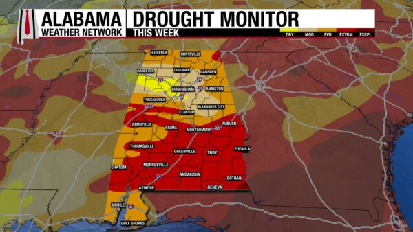
Although we are still in a very serious drought, conditions have improved from last week to this week, thanks to the rain we’ve seen recently. 4.77% of the state is Abnormally Dry, compared to 0% last week. Also, now 16.99% of the state is in a Moderate Drought, when only 11.32% of the state was in a Moderate Drought last week. Of course, we want these categories to be zero while the No Drought category is 100%, but these increases mean that drought conditions are lessening in some areas of the state. The Severe Drought category dropped by about 4%, and the Extreme Drought category dropped by around 6%. As less of the state is in these very bad drought conditions, they transition to still bad, but better drought levels. The southeast corner of Alabama is still in an Exceptional Drought, but the category’s percentage did not increase.
MORE STORMS ON THE COAST
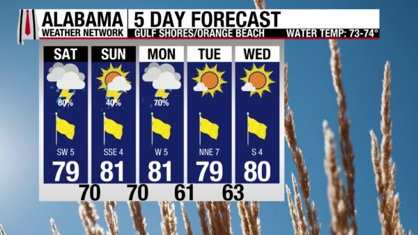
An 80% chance of thunderstorms is expected on the coast today; it’s definitely a board game and movie kind of day. The high is in the upper 70s, and winds are from the south at 5 to 10 mph. If (or when) it’s not storming, skies will be overcast, and the UV Index will be low. Waters are somewhat rough, with a Moderate rip current risk in effect and a surf height of 1 to 2 feet. You should not be in the water if lightning is nearby. Tuesday features our earliest hope of better weather.
TODAY IN WEATHER HISTORY
May 9, 2003 – Gary England’s Close Call
On the evening of May 8, 2003, veteran Oklahoma City television meteorologist Gary England of KWTV played a central role in communicating life-saving warnings as a long-lived supercell thunderstorm tracked across central Oklahoma and produced at least ten tornadoes, including strong F3 and multiple F1 tornadoes that affected the northern Oklahoma City metro area and continued northeast toward Tulsa. The storm developed along a retreating dryline in southwest Oklahoma and moved across the state, producing tornadoes mostly after dark along with large hail, damaging straight-line winds, and significant flooding rainfall that complicated emergency response. As the tornado approached Oklahoma City just after 10 p.m., England’s storm tracker network reported that the circulation was nearing the station, prompting him to evacuate the studio and move staff into a designated safe room, a moment he later described as, “a sardine can with too many sardines,” while noting it was the first time in 30 years on air he had been truly scared. Despite the rapidly evolving threat, he continued coordinating coverage, emphasizing the danger of nighttime tornadoes as the supercell crossed the metro area, which ultimately left widespread destruction in Moore with hundreds of homes damaged or destroyed, more than 100 injuries, and at least one death in the Oklahoma City area. The same storm system also produced damage along a path paralleling the Turner Turnpike toward Tulsa, including renewed impacts in Stroud, which had been heavily affected in the 1999 outbreak.
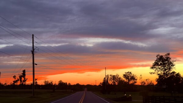
IMAGE OF THE DAY
Skywatcher Daniel Harbin captured a gorgeous sunset over the mountain in Henagar last night!



