


Daily Briefing
An upper trough and associated low pressure system will bring some rain and a little thunder to the northern half of Alabama today. Cooler weather will return tonight, but a warming trend will begin by Tuesday.
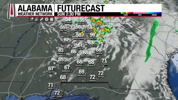
SUNDAY SHOWERS
Light rain and a few pockets of moderate showers will work across North and Northeast Alabama today as the upper low swings through; a brief gusty storm is possible east of I-65 late morning to midday. Central Alabama sees clouds with just spotty light showers, while the south remains mostly dry with increasing sun. Highs will range from upper 40s and low 50s in the Tennessee Valley to mid/upper 60s closer to Montgomery and Mobile.
POSSIBLE PATCHY FROST TONIGHT NORTH
Skies clear quickly this evening with northerly breezes easing overnight. Lows fall into the mid to upper 30s north and west of Birmingham where patchy frost may form in calm pockets, especially in Northwest Alabama. Elsewhere lows settle in the upper 30s to low 40s with a crisp feel statewide.
SUNNY MONDAY AND COOLER START
Monday brings wall-to-wall sunshine across Alabama with highs in the upper 50s north and low to mid 60s central and south. A light north breeze keeps the air dry and crisp. Monday night again turns chilly — upper 30s north to lower 40s south — with another shot at patchy frost in sheltered northern valleys.
TUESDAY THROUGH THURSDAY: WARMING AND DRY
Quiet weather continues as high pressure builds overhead and winds turn southerly mid-week. Highs climb steadily — mid 60s Tuesday, then low to mid 70s Wednesday and Thursday with cool nights in the 40s to lower 50s. Sunshine dominates as humidity stays low until late week.
FRIDAY AND SATURDAY: ABOVE NORMAL TEMPS, CLOUDS INCREASE
A warmer end to the week with highs pushing the upper 70s by Friday and Saturday under a mix of sun and scattered clouds. Southerly flow increases moisture a touch, but most of the state stays dry through Friday. Showers could return Saturday as a cold front approaches for the weekend. Lows trend milder — upper 40s north to upper 50s south.



