


No changes to the watches/warnings for Tropical Storm Debby on the 10pm Advisory. Earlier I said that the Tropical Storm Warning included the City of New Orleans, but I was mistaken about that.
Center: 26.3N 87.5W
Movement: Stationary
Max Winds: 50 mph
Pressure: 998 mb
NOTES
…61 knot flight level wind in the northeast semicircle, not associated with convection. This translates to nearly 50 knots, so the 50 mph intensity is probably conservative
…Debby now forecast to be a hurricane by Tuesday night. The advisory cautions that it could occur by Monday night
…Not much change in the forecast track
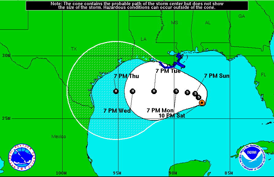
…Still not much agreement among the models, so the forecast is not poured in concrete. The GFS is the outlier, but it does not accurately represent the environment around the storm.
…Some oil rigs in the northern Gulf are being evacuated in the face of Tropical Storm Debby. It is not expected to affect oil production. A couple of tornado touchdowns around Naples FL Saturday afternoon thanks to Debby. One injury was reported.
…The fourth named storm in the Atlantic typically occurs by Aug 23. When Tropical Storm Debby made her debut Saturday afternoon, it marked the earliest that the D storm had been named in the satellite era, breaking the previous record held by Dennis in 2005. There is an important footnote, however, Debby is the first named storm this season to have formed as a purely tropical system (warm core).
…Forecast motion: Would you like a plate of spaghetti? That’s what the model tracks look like. This one is going to be hard to figure out. The models are all over the board. We just have to see how the upper air pattern evolves. But the NHC is very confident that it will turn to the west.
IMPACTS ON GULF COAST WEATHER.
…Tides were already running high along the northern Gulf Coast thanks to the persistent east southeasterly low level flow that was pushing water up against the coast.
…The short range motion of Debby through the weekend will pull it about 150 miles closer to the coast of Southeast Louisiana, Mississippi, Alabama and the Florida Panhandle. This will pull showers and storms into coastal areas, but it won’t be a total washout. Rainfall amounts from the storm will average about an inch along the immediate coast.
…Temperatures will be seasonably hot.
…Persistent east southeast winds will continue an onshore flow that will drive tides of two feet above normal along the Gulf Coast from southeastern Louisiana to Northwest Florida. This will result in coastal flooding which could inundate some low lying areas like the western end of Dauphin Island, the Mobile Causeway and the road to Fort Pickens in Pensacola.
…Waves will build to 5-7 feet, which will lead to erosion and will cause severe rip currents. Bodysurffing will not be recommended along the beautiful beaches of Alabama and Northwest Florida through Monday. In fact, Baldwin County beaches are reportedly closed on Sunday.
…Winds will be brisk, averaging 10-20 mph.
SHOULD YOU CHANGE PLANS? If you are heading to the Gulf Coast of Alabama or Mississippi this week, I would not change my plans. Just know that the ocean will be dangerous and should be avoided at all costs. There will be heavy rain at times and it will be breezy. But keep a very close ear to the latest advisories and information on Tropical Storm Debby.



