


Daily Weather Briefing
Saturday, August 22, 2026
ALABAMA THIS MORNING
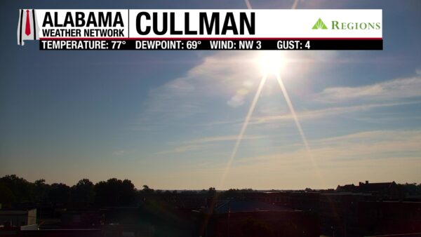
Clouds stretch across much of central Alabama, but northwest Alabama is clear, and the south is mostly clear. Temperatures are in the upper 60s in the northwest corner of the state while the rest of Alabama is in the low 70s. The sun is bright over Cullman, seen on the Region’s Skycam.
ALABAMA 7 DAY FORECAST
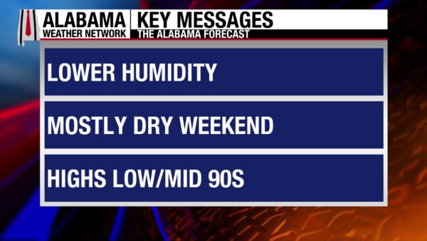
As we head into the weekend and the last week of August, we finally break out of the hot, isolated thunderstorm pattern. The ridge responsible for that weather will sit over the Western U.S. this week, keeping us on its eastern edge. This will allow shortwave energy to move through Alabama throughout the week. This means we’ll be in a bit of an unsettled pattern, with storm complexes possibly pushing through Monday through Friday next week. The stormier conditions will keep us less hot. Before that, this weekend will be on the dry side.
MOSTLY DRY WEEKEND AHEAD – Aug 22 – 23
This weekend will be mostly dry thanks to a few surface fronts that have already moved through or will move through Alabama. They are/will be responsible for drier and slightly less hot air filtering into the state.
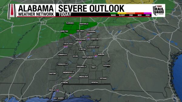
On Saturday, rain chances will be between 10-30% from north to south, and highs will reach into the low to mid 90s from north to south as well. Western-central Alabama has the capacity for a few locations to reach the upper 90s. There is also a Marginal Risk (1/5) for north Alabama tonight to see severe thunderstorms that could produce damaging winds, frequent lightning, and heavy rainfall. Timing seems to be after 8 p.m., with storms fizzling out around midnight.
Sunday will see a 20-30% chance of rain across the state and highs int he low 90s north, mid 90s centrally, and mid to upper 90s south. Any storms that develop will be isolated to scattered and should stay below the severe thresholds.
UNSETTLED WEATHER PATTERN BEGINS MONDAY – Aug 24
The ridge that made us so hot last week will continue to move west throughout the week ahead, while an upper-level trough will dig over the Northeast. This set up will allow shortwave energy, or storm energy, to move into Alabama throughout the week, so periods of rain and storms each day are possible. Rain chances on Monday will still be around 20-30%, while highs will only reach the upper 80s north, low 90s centrally, and mid 90s south. The timing of the stormier weather is still hard to pinpoint.
TYPICAL AUGUST WEATHER THROUGH THE WEEK – Aug 25-28
Tuesday through Friday will see weather typical for this time of year: the 20-30% of scattered afternoon thunderstorms and highs in the low 90s. Those periods of storms and rain are still possible each day, but again, timing is difficult to pin down.
On Tuesday, highs will range from the upper 80s to low 90s in the north to the low 90s across the rest of Alabama. The low 90s will stretch over the state on Wednesday. Thursday will see the low 90s with a few upper 80-degree readings sprinkled in, and Friday will be the same.
RAINFALL OUTLOOK
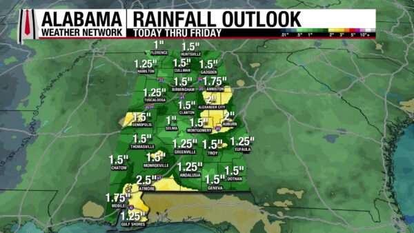
With the stormier pattern we’re entering this week, Alabama is set up to receive a decent amount of rainfall over the next week. The state could receive anywhere between an inch and 2 and a half inches of rain, with locally higher amounts possible from thunderstorms.
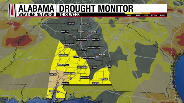
SOUTHERN DROUGHT SPREADS
The northern two-thirds has received plenty of rain to keep the drought at bay, but South Alabama is seeing Abnormally Dry (D0) conditions spread and Moderate Drought (D1) conditions creep up in the southwest. Last week, no part of the state was experiencing moderate drought conditions, while 5.76% of the state is under these conditions now. Furthermore, 23.13% of Alabama was experiencing Abnormally Dry conditions last week, while 34.62% of the state is experiencing them now.
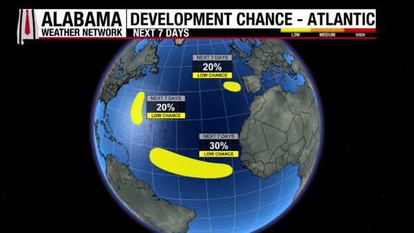
THE ATLANTIC
In the Atlantic Ocean basin, the National Hurricane Center has outlined three disturbances that could develop tropically over the next week. In the Northeastern Atlantic, the disturbance has a 20% chance; in the Central Subtropical Atlantic, the disturbance has a 20% chance as well, and in the Eastern Tropical Atlantic, the disturbance has a 30% chance.
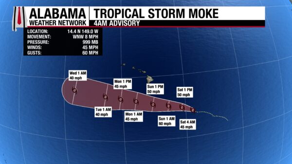

THE PACIFIC
In the Pacific, Lala is still a Category 1 hurricane with sustained winds of 85 mph. Meanwhile, Tropical Storm Moke has sustained winds of 45 mph and a central pressure of 999 mb as it sits southeast of Hawaii. It is expected to stay a tropical storm as it moves south of Hawaii Sunday and Monday but will still bring anywhere from 5-15 inches of rain to the Big Island, as well as gusty winds and large swells. As the National Hurricane Center keeps its eye on Moke, it is also watching a cluster of three disturbances in the Eastern Pacific. The more western one has a 60% chance of developing, the southern one has a 30% chance of developing, and the eastern one has a 70% chance of developing into a tropical system over the next week.
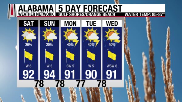
GOOD BEACH WEEKEND, RAINIER THIS WEEK
Today and tomorrow will be pleasant beach days with a rain chance of 20%, mostly sunny skies with a Very High UV Index, and winds from the west around 5 mph. Both days have a 20% chance of showers and thunderstorms. Similar conditions are expected this week, except rain chances jump to 40%. The rip current risk is Low, and the surf height is around 1 foot today.
TODAY IN WEATHER HISTORY
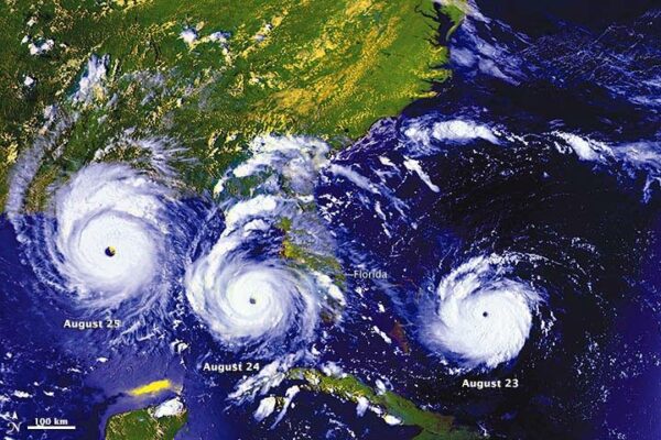
August 22, 1992 – Andrew Awakens
For much of its first week, Andrew hardly looked like a future monster. The tropical storm struggled against strong upper-level winds as it crossed the Atlantic, and for a time forecasters wondered whether it might weaken further. That changed dramatically on August 21 as a strong area of high pressure developed north of the storm. The atmosphere became more favorable, Andrew turned toward the west, and its circulation began organizing rapidly.
By 5 a.m. Saturday, August 22, the National Hurricane Center had seen enough: Andrew had become the first hurricane of the 1992 Atlantic season. Operationally, its maximum sustained winds were estimated at 75 mph. The center was still roughly 800 miles east of Miami, and the early official forecast did not yet point directly toward South Florida. In fact, the morning forecast placed Andrew offshore of central Florida early Tuesday as a hurricane with winds near 100 mph.
Forecasting hurricane tracks was considerably more difficult in 1992. Three-day track errors averaged roughly 340 miles, and forecasters had far fewer computer models and observations than they do today. One of the important models was the Aviation Model, or AVN, an ancestor of today’s GFS. It showed a strengthening high-pressure ridge north of Andrew, a feature capable of blocking the hurricane from turning north and instead driving it faster westward. As Saturday progressed, Andrew repeatedly moved left of the predicted track, and by the 5 p.m. advisory the projected landfall had shifted south toward Boca Raton and Deerfield Beach.
At 5 p.m., the National Hurricane Center issued a hurricane watch from Titusville southward through Miami and across all of the Florida Keys. By then Andrew was roughly 600 miles east of Miami with sustained winds near 100 mph, and by 11 p.m. those winds had increased to 110 mph as the forecast track shifted still farther south toward Dade County. In less than a day, Andrew had gone from a struggling tropical storm to a strengthening hurricane racing toward Florida, and South Florida’s countdown had begun.

IMAGE OF THE DAY
Skywatcher Chris Cheatwood sent a photo of the sunset from Victoria, British Columbia, Canada, last night!



