


Daily Weather Briefing
Thursday, July 30, 2026
ALABAMA THIS MORNING
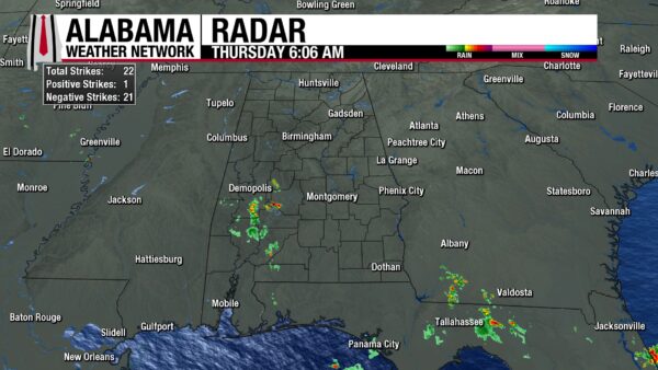
North, central, and south Alabama wake to different weather conditions this morning. North Alabama is a little foggy this morning, as temperatures and dew points sit in the low 70s, but no clouds cover the sky. Central Alabama is warmer, sitting in the mid 70s with clear skies and dew points in the 70s. South Alabama is cloudier, especially to the west, as a few showers and thunderstorms stretch from north of Butler to Marion to as far south as Barnett Crossroads. Temperatures are in the upper 70s to even 80 degrees already, and dewpoints make it feel muggy as they sit in the mid to upper 70s.
ALABAMA 7 DAY FORECAST
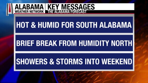
The northern two-thirds of the state will be dry today, while south Alabama could see strong to marginally severe storms this afternoon and evening, but not before they heat up again. Tomorrow sees the end of the heat as rain is expected across the southern half of the state, and the northern half enjoys one more dry day. We enter a wet pattern this weekend as a low-pressure system moves north and sends a cold front through the state. Rain chances will stay in the medium to high range until an attempt to dry out is made next Wednesday.
DRY NORTH, STORMS AND HEAT SOUTH – July 30
After yesterday’s frontal passage through the northern half of the state, the atmosphere in the region has begun to dry out some. Throughout the day, dewpoints will drop into the mid 60s to low 70s in the northern half of the state, which will create a more pleasant-feeling day, especially compared to earlier this week. This is true despite the fact that highs will still rise to the upper 80s and lower 90s. The dry air will also keep rain at bay, and the region will be mostly dry.
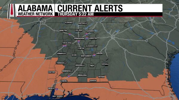
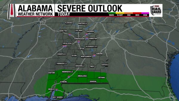
The southern half of the state will still battle the heat and humidity for one more day, which will lead to storms this afternoon and evening. South-central Alabama will struggle less with these factors, seeing dew points fall to the low 70s by the afternoon and highs teeter between the low to mid 90s, keeping the region out of a Heat Advisory. But south Alabama will have the stalled surface boundary sit over the region today, keeping dewpoints in the mid to upper 70s, highs in the mid 90s, and feels-like temperatures in the 108-112 range. Therefore, a Heat Advisory is in effect for the region until this evening for Choctaw, Washington, Mobile, Baldwin, Clarke, Geneva, and Houston Counties. As we head into the afternoon, showers and thunderstorms will develop in a scattered nature across the south into the evening, and they have a Marginal (1/5) Risk of becoming severe. Damaging winds, frequent lightning, and heavy downpours are possible with any strong to severe thunderstorms.
HEAT DISSIPATES TOMORROW – July 31
Tomorrow should see the end of the hotter temperatures as only the southeast could hit those oppressive feels-like temperatures. The north will stay mostly dry tomorrow, holding onto those lower dewpoints. Although no rain is expected, skies will be partly to mostly cloudy ahead of the low-pressure system that will bring rain this weekend. Highs will rise to the upper 80s and lower 90s again. Central Alabama should be mostly dry as well, but there is a slightly higher chance of an isolated to scattered shower or thunderstorm in the afternoon in response to the increasing moisture from the approaching system. Highs will sit in the low to mid 90s. Meanwhile, south Alabama will see clouds throughout the day and isolated to scattered showers and thunderstorms from the afternoon into the evening, finally relieving the region of its hot temperatures. Highs should return to the low 90s, but a few mid-90-degree readings are possible, and there is a low to medium chance the southeast could see just one more day of heat-advisory level heat.
WET WEEKEND AHEAD – Aug 1-2
A wetter and cooler pattern settles in across Alabama this weekend as the low-pressure system mentioned above pushes west just north of the state. Its associated cold front will move right through Alabama this weekend.
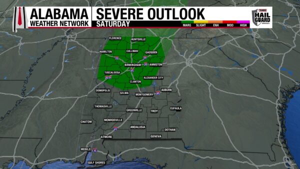
On Saturday, a large swath of showers and thunderstorms will push through Alabama, with widespread coverage expected over the northern half of the state, while the southern half of the state may see more scattered thunderstorms. There is a Marginal (1/5) Risk that storms from north into central Alabama will become severe and produce damaging winds, frequent lightning, and heavy downpours. Good news for those tired of the heat: the rain will keep highs limited to the mid to upper 80s statewide!
Sunday will still be rainy, but coverage may be slightly less widespread. Regardless, continuous clouds and periods of rain will keep highs in the mid to upper 80s again, with a 90-degree reading or two possible.
WET PATTERN CONTINUES INTO NEXT WEEK – Aug 3-4
Rain chances stay elevated through Monday and Tuesday as the atmosphere stays moist due to the surface low pressure system’s upper-level trough hanging out in the southeast. Highs are expected to be in the upper 80s Monday with a few low 90 readings sprinkled in again. Tuesday sees the upper 80s again, but the low 90s will be more widespread.
CHANCE TO DRY WEDNESDAY – Aug 5
As the upper-level trough associated with the low-pressure system lifts out of the southeast Wednesday, the upper-level ridge to the west will work its way back into Alabama. This will decrease rain chances and increase highs to the lower 90s over the southern two-thirds of the state, while north Alabama clings to its upper 80s.
RAINFALL OUTLOOK
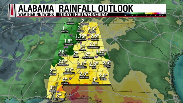
As we head into the wet pattern this weekend and early next week, Alabama could see anywhere from 1-4″ of rain. The lower end of this range is expected in northwest Alabama, while 2 to 3” is expected over the rest of the state. The 4-inch possibility stays to the most southern portions of the state along the Alabama-Florida border.
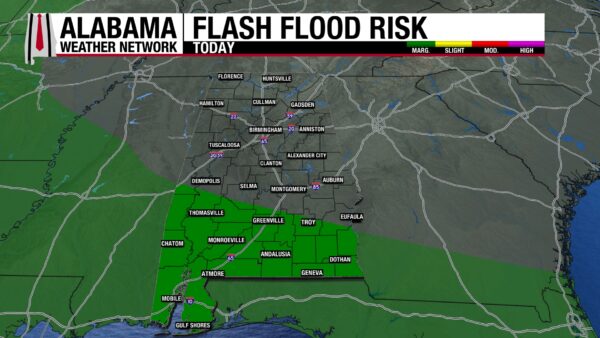
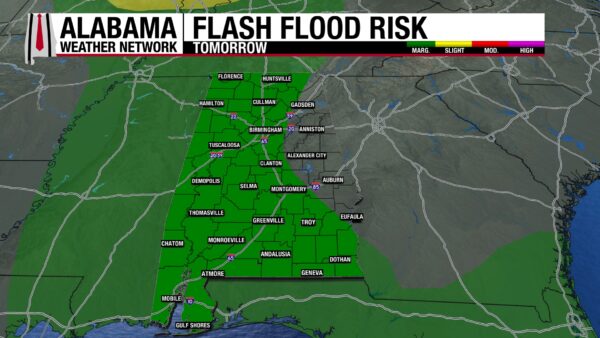
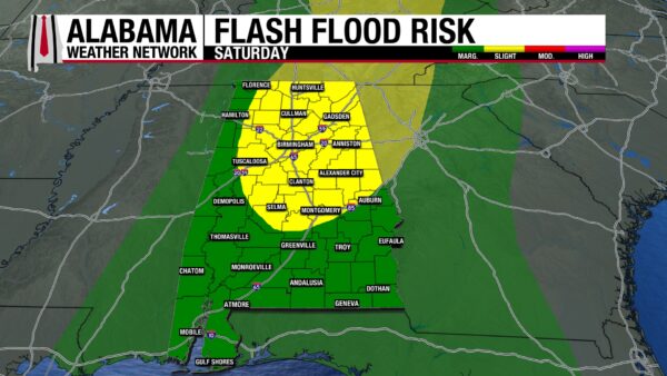
There is a Marginal Risk (1/4) for Flash Flooding across south Alabama today and the same risk across the western two-thirds of Alabama tomorrow. This is because any storms that develop will have a decent chance of being downpours, and flash flooding, especially in low-lying areas, is possible. On Saturday, the eastern two-thirds of north and central Alabama will be under a Slight Risk (2/4) for Flash Flooding, while the rest of the state will be under a Marginal Risk. Storms ahead of the front will be efficient rainfall producers.
GENEVIEVE IS THE LAST MAN STANDING
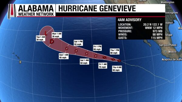
After a few weeks of multiple areas of low-pressure to watch for development and two hurricanes in the Pacific, Hurricane Genevieve is now the lone holder of the National Hurricane Center’s attention. At Category 1 strength with sustained winds of 90 mph and a central pressure of 973 mb, it has weakened since yesterday and is expected to weaken tomorrow and this weekend. By Friday afternoon, Genevieve is expected to be a tropical storm. It continues its west-northwest track and will not make any land impacts.
WET WEEKEND ON COAST AHEAD
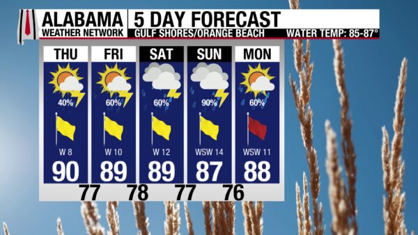
Today, there is a 40% chance of afternoon showers and thunderstorms, but before the afternoon storms develop, the sky will be mostly sunny, and the UV Index will be Very High. Today’s high is around 90 degrees, and winds will blow from the west around 10 mph. Today’s rip current risk is Moderate, and swimmers should take extra precaution. Tomorrow through Monday looks stormier, but most days should not be a complete washout.
TODAY IN WEATHER HISTORY
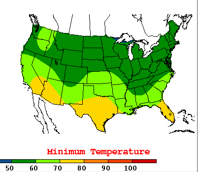
On July 30, 2014, Alabama woke up to a morning that felt almost impossible for late July. Instead of thick humidity and warm dawn temperatures, much of the state had cool, dry air in place under an unusual upper-level trough over the eastern United States.
The lows were startling. Birmingham dropped to 57 degrees, Anniston fell to 54, Tuscaloosa reached 56, Huntsville dropped to 56, and Muscle Shoals recorded 55. In some smaller communities, it felt even cooler, with 53 reported at Pinson and 49 at Crossville.
Montgomery’s low of 59 was especially impressive. It was not only a record low for July 30, but it also tied the all-time record low for the month of July in Alabama’s capital city.
The air mass did not last long, but for one morning, the state traded humidity for weather better enjoyed with the window open.

IMAGE OF THE DAY
The moon has been especially beautiful last night and this morning, and Skywatcher Daphne Johnston captured that with this photo of the moon in Warrior last night before the “cloud monster” ate it!



