


Daily Weather Briefing
Saturday, May 16, 2026

ALABAMA THIS MORNING
Clouds stretch across north and west Alabama this morning, while the rest of the state sees clear skies. The clouds keep the north and west warmer, with temperatures in the lower 60s right now. The rest of the state sits in the mid to upper 50s. Wind gusts reach up to around 15 mph in the north, while wind gusts range from 5 to 10 mph across central and south Alabama. It’s a beautiful morning for a walk! Skywatcher Daniel Harbin took this picture of altocumulus clouds that stretched across Trenton before sunrise this morning.
ALABAMA 7 DAY FORECAST
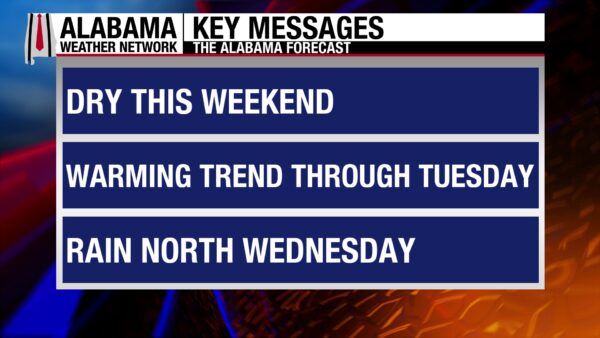
This weekend will be dry, and a warming trend will last through Tuesday. This is due to an upper-level ridge and associated high-pressure system over the Eastern U.S. Rain chances increase slowly Monday to Wednesday as an upper-level shortwave passes through the region and weakens the high-pressure’s influence. On Wednesday afternoon, a cold front will slowly push through Alabama but is expected to stall over the northern half of the state. This increases shower and thunderstorm chance over the area through Friday in the region. The southern half of the state will see low rain chances throughout the rest of the week.
DRY WEEKEND AHEAD
The upper-level ridge and surface high-pressure will settle into Alabama easily today. This spells out a rain-free weekend.
The high-pressure system will not stop the formation of clouds over Alabama today, and skies will be partly to mostly cloudy. Highs will rise into the mid 80s, with a few upper 80-degree readings possible in the southern half of the state.
Less clouds are expected Sunday, which will allow highs to soar into the upper 80s statewide. A location or two in north Alabama could hit 90 degrees.
LOW RAIN CHANCES MONDAY AND TUESDAY
As an upper-level shortwave moves through the region Monday and Tuesday, a low chance of showers and thunderstorms appears in the forecast for all of Alabama. Showers that develop will be isolated or scattered in nature, and no severe weather is expected.
The warming trend will continue, and highs on Monday will reach the upper 80s and lower 90s. The greater chance for low 90-degree readings is in the northern half of the state.
The lower 90s become more widespread Tuesday, but many locations will hold onto the upper 80s.
MORE RAIN MIDWEEK
As mentioned above, a cold front will push through north Alabama Wednesday and stall in central and south Alabama Thursday and Friday.
The rain chance in the northern half of the state Wednesday increases to 60% as showers and thunderstorms become more widespread. Highs will be limited to the mid 80s in the region. Rain chances only increase to 20% in the southern half, and highs will climb into the upper 80s and lower 90s. No severe weather is expected at this time, but the system will continue to be monitored through the next several days.
RAIN DWINDLES TO END THE WEEK
Rain chances fall to 30% in the northern half and stay at 20% in the southern half of Alabama Thursday. Storms will again be isolated and scattered, and highs will range from the low to mid 80s north to the upper 80s south.
Rain chances even out across the state to 20% on Friday. The north will stay in the low to mid 80s, while central Alabama sees a range of highs from the low to upper 80s. South Alabama will see highs once again in the upper 80s and lower 90s.
MORE IMPROVEMENT TO DROUGHT CONDITIONS
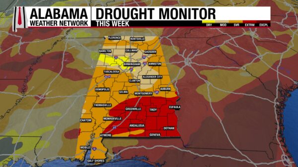
The heavy rains we received over the past two weeks have put a decent dent in the drought Alabama is experiencing right now, although there is much further to go. The southeast corner of the state is no longer in Exceptional (D4) Drought. Additionally, the Extreme Drought (D3) category has seen about a 20% decrease from last week to this week (41% to 21%). This means that the Severe (D2) and Moderate (D1) Drought categories have seen an increase in percent of the state they cover. Now, 50% of the state is under Severe Drought conditions and 23% of the state is under Moderate conditions. The area of the state that is Abnormally Dry (D0) remains unchanged from last week. Unfortunately, the rain we’re expecting next week will do little to further encourage drought improvement.
WONDERFUL BEACH WEEKEND
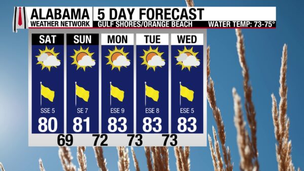
Beautiful weather is expected this weekend, so get out to the shore and soak up the sun! Today, the high will be 80 degrees, skies will be mostly sunny, the UV Index will be Very High, and winds will be from the southeast at 5 to 10 mph. If you get warm on the shore, the water will be nice to take a dip in as the rip current risk is Low and the water temperature is in the mid 70s. Waves are gentle today, with a surf height of around 1 foot. Good weather persists through the weekend and into the next week!

TODAY IN WEATHER HISTORY
May 16, 1874 – Dam Break Disaster
One of the deadliest flood disasters in early U.S. history unfolded in western Massachusetts on May 16, 1874, when a poorly designed dam on the Mill River catastrophically failed. The earthen structure, built to supply water for local mills, had long raised concerns due to questionable engineering and visible signs of weakness, yet no meaningful corrective action had been taken. Shortly after the breach, an estimated 600 million gallons of water surged downstream, forming a wall of water reportedly reaching 20 feet in height. The flood raced through a narrow valley, giving residents little to no time to react as it tore through the mill communities of Williamsburg, Skinnerville, Haydenville, and Leeds. Entire buildings were swept from their foundations as mills, homes, and bridges were destroyed along a roughly 12-mile path. The industrial nature of the valley meant many victims were workers and families living close to the river, contributing to the high death toll. In total, 139 people were killed, making it the deadliest flood-related disaster in the United States up to that time. The Mill River disaster became a defining example of the dangers of inadequate engineering oversight. Investigations after the flood highlighted failures in design, construction, and accountability, helping to spark early discussions about dam safety standards and the responsibilities of those who build and maintain such structures. The tragedy remains a stark reminder that not all flood disasters are purely natural—some are the result of preventable human decisions.
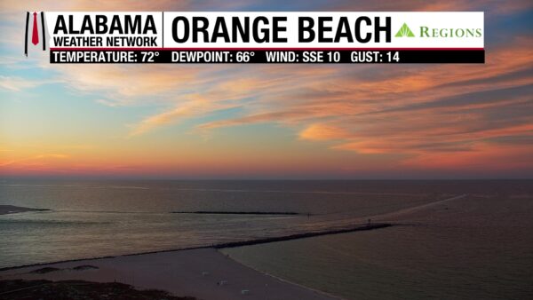
IMAGE OF THE DAY
The Orange Beach Regions Skycam captured the colorful Saturday sunrise on Alabama’s coast.



