


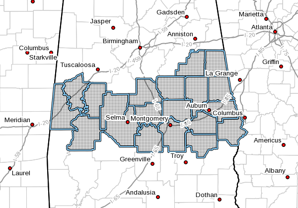
…FLASH FLOOD WATCH IN EFFECT FROM MIDNIGHT CST TONIGHT THROUGH THURSDAY AFTERNOON…
The National Weather Service in Birmingham has issued a Flash Flood Watch for portions of central Alabama, east-central Alabama, southeast Alabama, and west-central Alabama, including the following areas, in central Alabama, Autauga, Chilton, Coosa, Dallas, Elmore, Lowndes, Montgomery, and Perry. In east-central Alabama, Chambers, Clay, Lee, Macon, Randolph, Russell, and Tallapoosa. In southeast Alabama, Bullock. In west-central Alabama, Greene, Hale, Marengo, and Sumter.
From midnight CST tonight through Thursday afternoon
Rainfall amounts of 1.5 to 2 inches with locally higher amounts are possible in a short amount of time
Ongoing river flooding may be worsened and the high creeks and streams may affect the runoff of the new rainfall and produce flooding
PRECAUTIONARY/PREPAREDNESS ACTIONS…
A Flash Flood Watch means that conditions may develop that lead to flash flooding. Flash flooding is a very dangerous situation.
You should monitor later forecasts and be prepared to take action should Flash Flood Warnings be issued.



