


Daily Weather Briefing
Wednesday, July 29, 2026
ALABAMA THIS MORNING
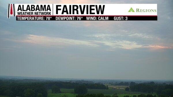
This morning is gloomy as clouds stretch across Alabama. Clouds covered the sky throughout the night, keeping low temperatures on the warmer side, causing temperatures now to sit in the mid 70s to around 80 degrees. Our Regions Skycam in Fairview gives us a less gloomy look this morning as some pinks from the sunrise peek through the clouds.
ALABAMA 7 DAY FORECAST
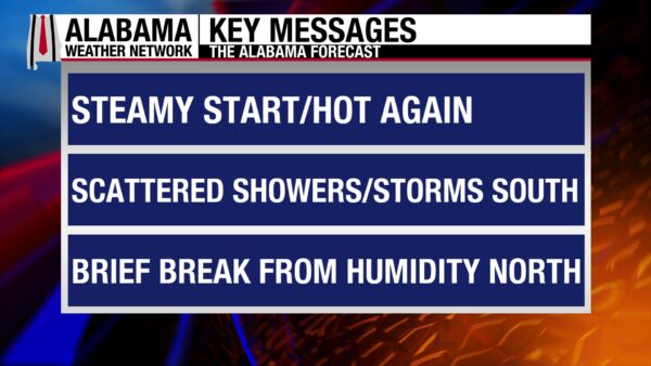
A cold front will push through Alabama today in response to an upper-level trough over the Eastern U.S. digging further south. It will bring scattered showers and thunderstorms, cloudy skies, and lower high temperatures to the northern half of the state. The southern half of the state will experience one more hot day before the front reaches the region in the evening. Showers and thunderstorms will have a low chance of becoming severe. Behind the front on Thursday, most of the state will be dry, but the front will linger over south Alabama, keeping scattered afternoon thunderstorms with a low severe threat in the forecast. The heat, however, will be suppressed. A similar forecast is expected Friday, but severe weather should no longer be of concern. This weekend, a low-pressure system will push through states to our north, bringing higher rain chances to Alabama through the beginning of next week.

RELIEF FROM HEAT NORTH, STILL HOT SOUTH TODAY – July 29
As the front pushes through Alabama this morning, showers and thunderstorms will be scattered across the northern half of the state. No severe weather is expected, and cloud cover and the rain will keep highs limited to the low 90s north and mid 90s centrally. Some locations in central Alabama will see the rain later in the afternoon than in the morning, so feels-like temperatures will be able to rise to around 105 degrees, and counties like Tuscaloosa, Pickens, Bibb, and Chilton are included in the Heat Advisory that stretches across the southern half of the state.
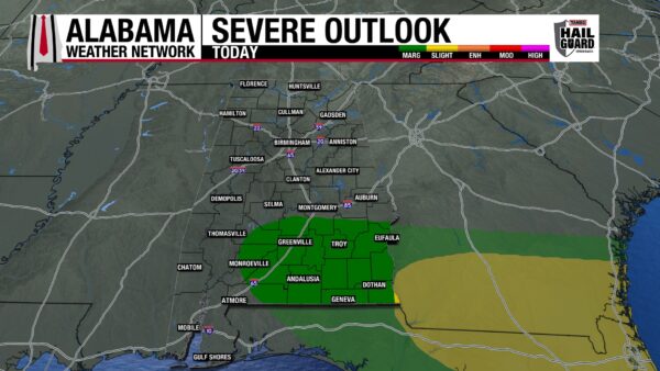
As we shift our focus south, the forecast calls for another very hot day, with feels-like temperatures soaring into the 105-110-degree range. Along with the Heat Advisory, there is an Extreme Heat Warning in effect for Alabama’s coast as they anticipate another day of feels-like temperatures in the 110-115-degree range. The front will take its time reaching the southern half of the state, with rain chances not picking up until the afternoon and dwindling around midnight. Showers and thunderstorms will be scattered to numerous, especially in the southeast. There is a low chance for storms to become severe from Conecuh, Wilcox, and Escambia Counties west to the Georgia state line, and from south of Montgomery to the Florida state line. Therefore, there is a Marginal Risk (1/5) for severe thunderstorm outlook placed over the region by the Storm Prediction Center. Any severe storms that develop could produce damaging winds, frequent lightning, and heavy downpours.
MOSTLY PLEASANT DAY TOMORROW, WET SOUTH– July 30
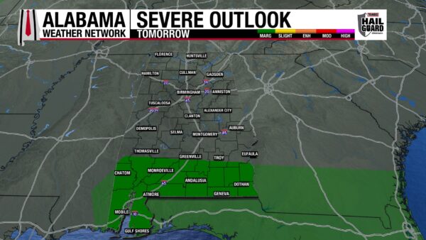
Behind the cold front, dry air will filter into the state, and dewpoints will drop into the upper 60s and lower 70s over the northern two-thirds of the state. This will keep the region feeling much more pleasant than it has in the first half of this week. Highs will only reach the upper 80s in the north and the lower 90s through central Alabama. The dry air will also keep the region rain-free tomorrow. Unfortunately for the southern half of the state, the front will stall over the region, keeping scattered to numerous rain chances elevated. Although it may not be cooler due to a new air mass, south Alabama will see highs limited to the mid 90s because of the rain and cloud cover. Afternoon storms across the entire region have a Marginal (1/5) Risk of becoming severe and producing damaging winds, frequent lightning, and heavy downpours.
DRIER WEATHER ENDS FRIDAY – July 31
As July comes to an end, the northern half of the state will enjoy another dry and less oppressively hot day. Highs will range from the upper 80s to lower 90s in the north and the low 90s centrally. The stalled front in the south will bring another round of scattered afternoon thunderstorms to the region, keeping highs limited with rain and cloud cover to the low 90s. No severe weather is expected.
WETTER WEEKEND AHEAD – Aug 1-2
As we head into this weekend, a low-pressure system to the north will bring unsettled weather and higher rain chances to the entire state. Specific timing is difficult to determine right now, so if you have outdoor plans this weekend, keep an eye on our forecasts the rest of this week. Highs will only reach the mid to upper 80s on both Saturday and Sunday.
WET PATTERN CONTINUES NEXT WEEK – Aug 3-4
It looks like Alabama will hold onto its wet pattern into next week, with rain chances staying elevated. Highs will still only hit the mid to upper 80s Monday, while a few 90-degree highs sneak in on Tuesday. Still, most of the state will be in the upper 80s.
RAINFALL OUTLOOK
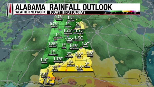
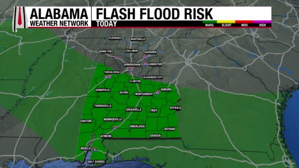
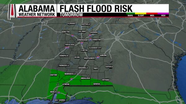
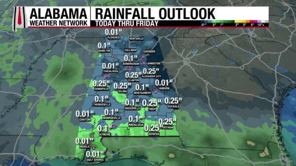
Most of Alabama will receive anywhere from an inch to 3 inches of rain over the next week. The higher rainfall totals are expected in the south. Although we have two Marginal Risk (¼) outlooks for Flash Flooding today and tomorrow (southern two-thirds of the state today, south Alabama tomorrow), most of the rain will fall after Friday. Through Friday, Alabama will only pick up a tenth of an inch to a quarter of an inch of rain.
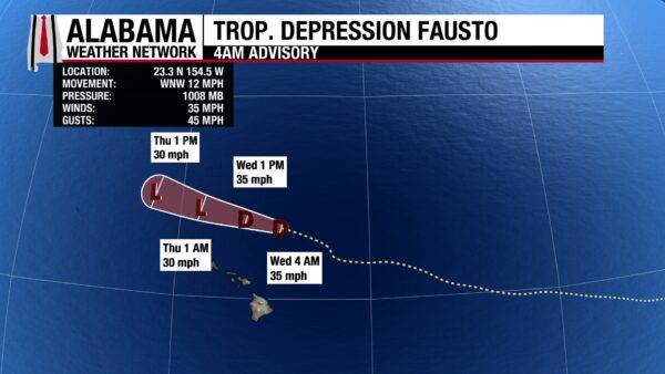
FAUSTO WEAKENS, GENEVIEVE STAYS STRONG
Fausto has weakened to tropical depression status with sustained winds of 35 mph and a central pressure of 1008 mb. It is north of Hawaii and will continue to weaken as it moves west-northwest today.
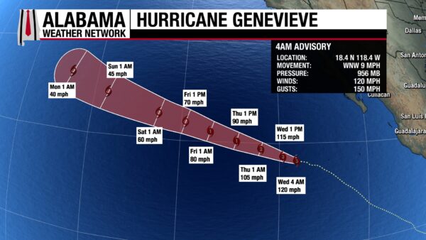
Hurricane Genevieve is a Category 3 with sustained winds of 120 mph and a central pressure of 956 mb. As it continues to move west-northwest at 9 mph, it will weaken to Category 2 status tomorrow morning. No land impacts are expected.
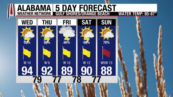
RAINY BEACH DAYS AHEAD
Today is one of the last decent beach days in the forecast as the coast enters a rainy pattern tomorrow. Today, the high will be in the mid 90s, skies will be mostly sunny, the UV Index will be Extreme, and winds will blow from the west at 10 mph. The water will be nice, as the rip current risk is low, and the surf height is around 1 to 2 feet. There is a 20% chance of afternoon thunderstorms, but besides that, today will be great (but hot)! As the front stalls over south Alabama tomorrow, rain chances increase to 60% from Thursday to Saturday. Afternoon and evening thunderstorms will be scattered to numerous, and sunshine will be harder to find. However, it shouldn’t be a washout. Rain chances jump to 70% on Sunday.
TODAY IN WEATHER HISTORY
July 29, 1912 – Mobile Bay Jubilee
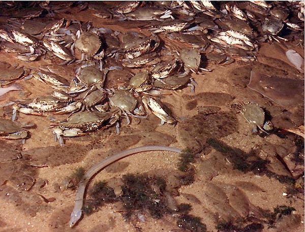
On July 29, 1912, the Mobile Daily Register gave a familiar coastal mystery a name that would last. Along Mobile Bay’s Eastern Shore, hundreds of live sea crabs and fish covered the beach at Point Clear and Zundels. Witnesses described the scene as unforgettable, with fish and crabs scrambling across the sand in large numbers.
The event itself was not new. People along Mobile Bay had seen similar shoreline migrations for generations, especially during warm-season mornings along the Eastern Shore. What changed in 1912 was the language. The newspaper used the word “jubilee,” helping turn a local natural event into a named part of Alabama coastal culture.
The science begins with the way Mobile Bay’s water can layer. Heavier, saltier Gulf water can settle near the bottom while lighter, fresher river water stays above it. Under calm conditions, that bottom water can stagnate, and oxygen levels can drop as organic material breaks down on the bay floor.
When wind, tide and water movement push that oxygen-poor bottom water toward shore, bottom-dwelling creatures are forced out of deeper water and into the shallows in search of oxygen-rich water. Crabs, flounder, shrimp, eels and other marine life may crowd the shoreline where people can gather them by hand, net or gig. The 1912 article gave Mobile Bay’s strange shoreline harvest the name that still defines it today.
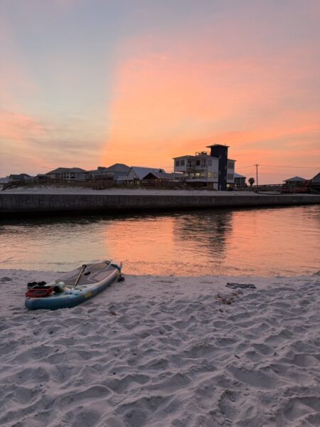
IMAGE OF THE DAY
@CountsDrake on X posted this wonderful photo of the sunset at Lagoon Pass, Gulf Shores last night.



