


RADAR CHECK: We actually have a few showers over Southwest Alabama early this morning, otherwise the weather is cool and dry with temperatures mostly in the 50s and 60s. We note Cullman dropped to 48 degrees just before daybreak.
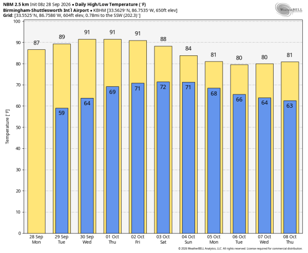
Today will be partly sunny with a high between 85 and 90 degrees; the early morning showers over the southwest counties won’t last long.
Heat levels will continue to rise; many communities will see a high in the low 90s over the latter half of the week as an upper ridge builds. Showers will stay few and far between through Thursday.
FRIDAY AND THE WEEKEND: Scattered showers are possible Friday, mainly over the southern half of Alabama… and summer-like temperatures continue with a high between 88 and 92 degrees for most places. Then, Saturday looks relatively wet as moisture continues to feed northward, the ridge weakens, and a surface front approaches.
This won’t be an all-day kind of rain, but periods of rain are likely along with some potential for thunder. For now we are not expecting severe thunderstorms. On Sunday the best chance of rain will be over the southeast part of the state as the front pushes southward. Beneficial rain amounts of 1-3 inches are likely over the weekend; highs will be in the 80s.
NEXT WEEK: Drier air returns, and at this point at least the first half of the week looks dry with highs around 80 degrees… See the video briefing for maps, graphics, and more details.
TROPICS: In the Atlantic, Tropical Depression Fay should dissipate far from land by mid-week. Elsewhere, a trough of low pressure (Invest 91L) located several hundred miles east-northeast of Bermuda is producing disorganized showers and thunderstorms. It could become a tropical depression over the next couple of days as it turns eastward to east-southeastward and slows down over the central Atlantic. Environmental conditions are expected to become unfavorable for further development later this week, and this feature will stay far from land.
In the Pacific, Polo is forecast to make landfall on the west coast of the Baja California Peninsula near major hurricane strength late today. Conditions are expected to begin to deteriorate there this morning… hurricane and tropical storm conditions are expected to spread across Baja California through tonight, and into mainland Mexico late tonight into early tomorrow. Moisture from Polo will support heavy rainfall and flooding potential across the Southwest U.S. into the Southern High Plains late today and tomorrow.
ON THIS DATE IN 1998: Hurricane Georges made landfall near Biloxi, Mississippi with maximum winds of 110 mph (category two strength). Georges brought a 12 foot storm surge to Dauphin Island and Fort Morgan/ The storm spawned 20 tornadoes throughout Alabama. The most devastating tornado touched down in Enterprise, causing severe damage to Camp Wiregrass and a few homes, while many residences in the city were left without electricity after numerous power lines were downed. Flooding was also a problem across South Alabama; Bay Minette’s total was 29.66″.
ON THIS DATE IN 2022: Hurricane Ian made landfall near Cayo Costa in southwestern Florida as a dangerous, high-end Category 4 storm after plowing a path of destruction through the Caribbean. On the morning of Sept. 28, 2022, Ian intensified into a Category 4 hurricane over the Gulf of Mexico, with maximum sustained winds of 155 mph, just shy of a Category 5 storm. Ian came ashore near Cayo Costa, Florida, at 3:05 p.m. EDT with maximum sustained winds of 150 mph, tying the record for the fifth-strongest hurricane on record to strike the United States.
Look for the next video briefing here by 3:00 this afternoon… enjoy the day!



