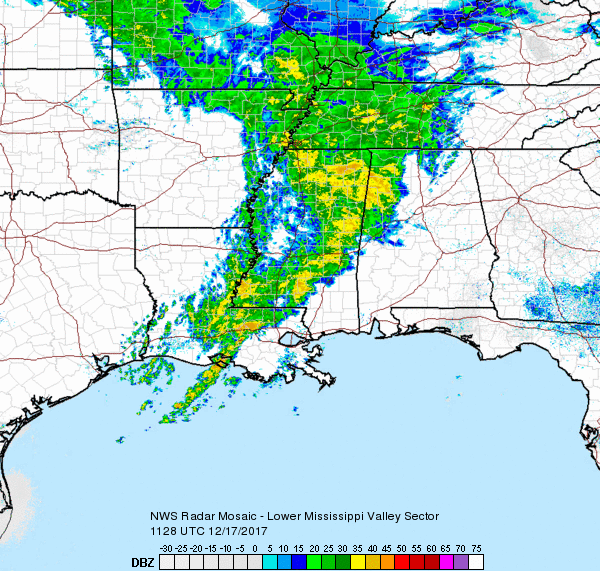
We start off with a temperature trace showing an unusual 10-degree increase in temperatures in Central Alabama from 2 to 5 am. Satellite image showed the Southeast US covered with clouds this morning, and the latest radar image showed a broad area of rain from Middle and West Tennessee to Southeast Louisiana. The area of rain was moving slowly but steadily eastward across Alabama, so it is going to be a wet one today with temperatures a tad cooler than yesterday as the highs are expected to reach near 50 degrees.
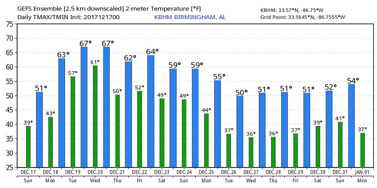
In the upper levels, the first of two strong short waves made it to the Ohio Valley this morning and will move off the Atlantic Coast Monday. In the meantime, there is the second closed low that is just beginning its journey out of the Southwest US Monday. As SPC notes, looks like the most favorable area for thunderstorms with a marginal risk will be over Southeast Louisiana for Day 1, just thunderstorms with no risk area for Day 2 across Southeast Texas Coast and Louisiana, and a marginal risk for Day 3 along the Southeast Texas Coast. Rain return Monday with a series of minor short waves often described as impulses move through the moisture-laden southwesterly flow aloft. Temperatures are going to depend highly on the placement of a weak stationary front lying east to west across Alabama. GFS MOS guidance paints 65 for the high Monday, but I think a little more realistic value is upper 50s or lower 60s due to clouds and rain once again.
Tuesday the strong upper low moves slowly to West Texas picking up speed Wednesday as it reaches the Mississippi River. Rain will once again develop ahead of this feature on Tuesday and move into Alabama late Tuesday and Wednesday. High temperatures both days will be in the 60s for Central Alabama.
The weakening feature aloft moves across the Southeast US on Wednesday and early Thursday bringing an end to the precipitation. High temperatures should remain in the 60s as the ridge beings to pump up across the Southeast US in response to the next trough/closed low digging into the Southwest US. Thursday and early Friday should be dry. But the dry spell is short-lived as a strong short wave over North Central US drags the trough out of the Southwest US into the Lower Mississippi River Valley on Saturday. So we should see rain once again from Friday afternoon into early Saturday afternoon before we dry out again on Sunday. But temperatures will remain fairly mild into the weekend with a mild southwesterly flow aloft.
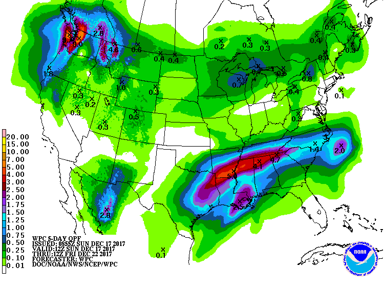
Rainfall over the next week is going to be concerning. Initially we should not see any issues because we have been rather dry, so the ground can absorb a lot of the rain that will fall. However, by Tuesday and Wednesday we will need to watch the specific locations and amounts of rain that fall because the ground will have become saturated, so if we’ll need to keep a close eye for the development of any heavy rain. Rainfall through Friday morning could be as much as 3 to 4 inches across the northern half of Alabama.
The mild weather comes to an end according to the GFS on Monday, Christmas Day, as a broad trough develops across practically the whole US taking us back to lows around freezing and highs from middle 40s to lower 50s. Looking further into voodoo country, the pattern really takes on a strange appearance by the 27th of December with a ridge over the Gulf of Mexico, but a strange looking elongated trough stretching from northern Utah all the way to Maine. By the 30th we see a short wave moving through the nearly zonal flow over Oklahoma with potential for producing some precipitation for the Lower Mississippi River Valley. At the very end of the forecast period, 372 hours out, the GFS paints a nearly zonal flow across the southern half of the US still seems somewhat anomalous but indicates an absence of any real cold weather for the Southeast US.
Beach Forecast: Click here to see the AlabamaWx Beach Forecast Center page. The Beach Forecast is partially underwritten by the support of Brett/Robinson Vacation Rentals in Gulf Shores and Orange Beach. Click here to see Brett/Robinson’s Hot Deals now!
WeatherBrains: Don’t forget you can listen to our weekly 90 minute netcast anytime on the web, or on iTunes. This is the show all about weather featuring many familiar voices, including our meteorologists here at ABC 33/40.
The next Weather Xtreme Video will be posted by James Spann at the crack of dawn on Monday. Stay dry in the days ahead and Godspeed.
-Brian-