


We continue to monitor the potential for a significant severe weather outbreak this afternoon and tonight across the Deep South. And it appears that storms could form out ahead of the main line as early as 1-3 p.m. acorss Northwest Alabama.
Sunshine has been breaking through over West and South Alabama this morning. There is quite a temperature difference across Central Alabama. The mercury has already risen to 77F at Tuscaloosa, with a 67F dewpoint. It is already 73F/70F at Jasper. At Birmingham, it is 68F/64F. Meanwhile, over East Alabama, a cold air wedge from Georgia and heavy clouds have kept readings in the 50s and lower 60s. It is now 62F/58F at Anniston, but 51F still at Carrollton GA.
With the increased temperatures and dewpoints behind the warm front, the instabilities are rising across West Alabam and Mississippi. South of I-22 and west of I-65, surface based CAPE values in Alabama are above 500 joules already, with widespread 1,500-joule values over West Alabama.
Values over the Mississippi Delta are approaching 2,500 joules. At Greenwood, MS, the current reading is 77F/68F. At Bastrop LA, it is 74F over 73F.
A line of storms now extends from just west of Houston to west of Shreveport to east of Little Rock and West of Memphis at this hour. These storms will intensify as they move into the warmer, more unstable air this afternoon.
The SPC maintains a moderate risk of severe weather (4/5) for this afternoon and evening across much of northern Mississippi into southern Tennessee and Northwest Alabama. An enhanced risk area (3/5) encircles the moderate risk and includes eastern Arkansas, northwestern Louisiana, western and Middle Tennessee and into southern Kentucky. Strong, long track tornadoes are possible in the enhanced and moderate risk areas this afternoon and into this evening.
A slight risk area (2/5) extends east across the northern half of Alabama. This area was expanded eastward on the 1030 a.m. issuance from the SPC. Damaging winds and a tornado or two are possible in the slight risk zone tonight as a squall line moves across the area.
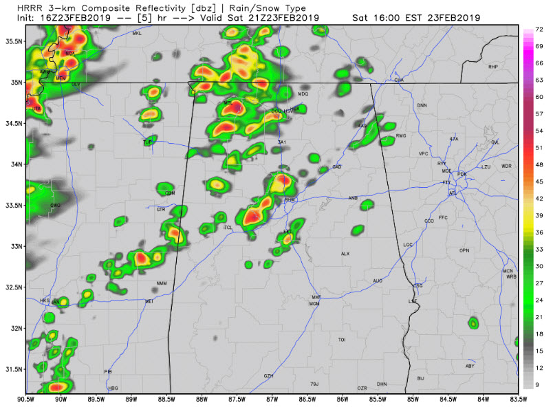
We will be watching any development ahead of the main line, perhaps as early as noon, across West Alabama. With instability values already climbing and good bulk shear and low-level helicity in place, severe weather could be possible if storms manage to form. Here is the HRRR at 3 p.m. showing healthy storms west of I-65 and north of I-59/20 over West Alabama.
Severe weather parameters will already be
Tornado watches will be issued shortly for parts of Louisiana, Arkansas, and Mississippi. They will be issued later for parts of Alabama as well.
Winds are starting to get gusty across the area. Wind recently gusted to 18 mph at the Shelby County Airport. The day will start to have more of a severe weather feel as we go into the afternoon.
TIMING
…Potentailly strong storms over Northwest Alabama between 1-7 p.m.
…Line of storms approaching West Alabama between 6:30-7:30 p.m. Tornado probabilities should be maximized about that time.
…Line reaches Jasper between 8-10 p.m., Cullman/Tuscaloosa between 9-11 p.m and Birmingham between 10-midnight.
…It should be weakening by then and will reach Gadedn between 11-1 and Anniston between midnight-2 a.m.
Now is the time to pull your severe weather safety supplies together and put them in your safe place. Hard soled shoes, helmets and long-sleeved clothing are important. Charge your cell phones and check your weatheradio.
Stay tuned for frequent updates through the afternoon and overnight here at Alabama WX.



