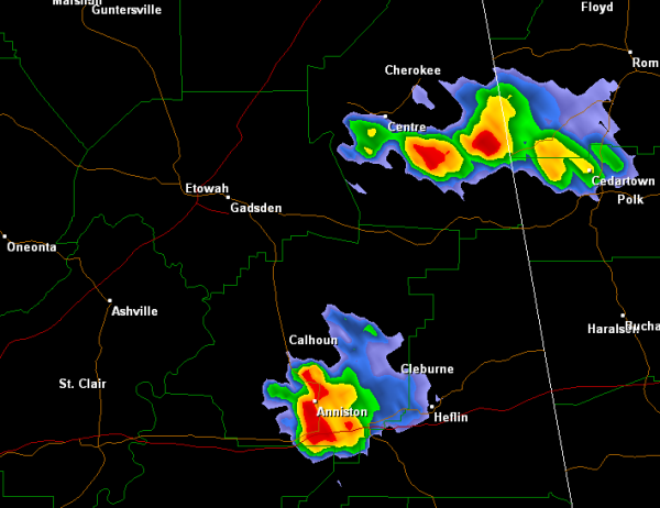
A few very isolated thunderstorms have developed over East Alabama this afternoon. One is over Cherokee County just to the southeast of Centre. The other is located in southern Calhoun and extreme northeastern Talladega Counties. The cities of Oxford and Anniston are being impacted by this storm as well as Interstate 20 and U.S. Highway 431. Neither of these storms are currently severe, but are producing some small hail and gusty winds. The main concern is the potential for flash flooding. The storms are moving very much and are dropping very heavy rainfall.
Published on: April 17, 2013 at 2:48 PM
Related Articles
October 30, 2026 at 3:02 PM
Some Rain At Times Over The Weekend
WARM AFTERNOON: Temperatures are between 77 and 82 degrees across Alabama this afternoon with sun through high cirrus clouds. No rain on radar. Clouds will increase tonight. We will mention a chance of showers statewide over the weekend. A few … Continue reading →
READ MORE
October 30, 2026 at 5:36 AM
Showers Return Over The Weekend
ONE MORE DRY DAY: For most of Alabama today will be the 19th consecutive day with no measurable rain. Expect a partly sunny sky with a high close to 80 degrees this afternoon. SHOWERS RETURN: Moisture levels will rise tonight, … Continue reading →
READ MORE

