The severe weather threat for the Severe Thunderstorm Watch continues.
SUMMARY…
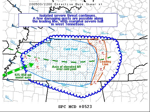
A few damaging gusts may accompany the leading line of a weakening bow echo across middle into eastern Tennessee, with some marginally severe hail accompanying storms northeast of Memphis.
DISCUSSION…
Though on a gradual downward trend, the severe threat continues across WW 0159 in association with a classic “bow and arrow” structured bow echo across middle into western Tennessee. The bow echo leading line continues to move into a mixed out low-level airmass across eastern Tennessee, with a weakening trend noted. Nonetheless, the leading line continues to traverse a region of steep low and mid-level lapse rates, suggesting that some damaging wind threat will continue with this convection for a few more hours.
Farther west, an 925-850 mb moist axis bissects the bow-echo training cold pool, optimizing parcel ascent atop colder, denser air to reach their LFCs across western TN, where stronger storms have been noted based on KNQA WSR-88D data, with up to golfball hail reported over the past hour. Low level moisture advection over the cold pool, with some steeper mid-level lapse rates gradually advection eastward, may foster some severe hail potential with the stronger storms.