


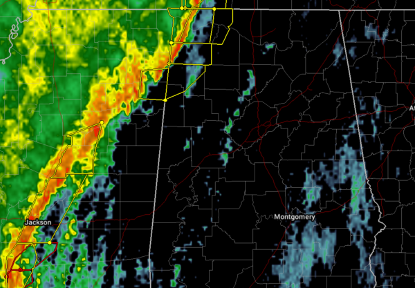
Watch Update…
A second tornado watch is in effect until 4 pm CST for areas toughly along and west oF Interstate 65 along with St. Clair County but not including Montgomery County at this time. The existing tornado watch for 5 northwest counties of Marion, Winston, Lamar, Fayette and Walker remains in effect until 1 pm CST.
Current Situation…
A line of strong to severe storms now extend from far Northwest Alabama southwest to near Jackson, MS. General shower activity was noted on radar across portions of East Mississippi and West Alabama.
Environmental Conditions…
KGWX NEXRAD VAD VWP wind profiler data along with our recently completed 7 am BMX sounding both indicate a highly sheared environment with 0-1 km Storm relative helicity values from 206 m2/s2 here in central Alabama to values around 350 m2/s3 closer to the AL/MS state line. Wind shear is more than sufficient to support severe storms capable of producing high winds and embedded tornadoes in the line along with in any discrete convection that can develop ahead of the line.
The convective line is being dynamically forced and will pose the broadest concern for high winds. Surface-based instability values are currently the limiting factor for supporting robust development ahead of the forced line of storms.
Higher instability (Surface-Based Convective Available Potential Energy, SBCAPE) values around 500 J/kg per mesonanalysis data was approaching our far southwest counties from the southwest and is expected to advance north and northeast with time through mid morning. As instability increases the potential for discrete convection will increase.
So far the stronger isolated cells that have formed ahead of the line have been observed interacting with and being absorbed into the line and then posing a tornado threat.
Special Soundings…
We plan to conduct an additional weather balloon launch around 9 am with another one potentially toward 12 pm if conditions permit locally.



