


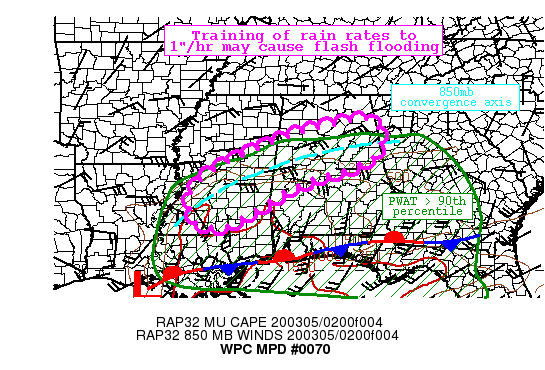
Areas affected…Central Mississippi, Central Alabama
Concerning…Heavy rainfall…Flash flooding possible
Valid 050428Z – 050930Z
Summary… Increasing coverage of showers with embedded thunderstorms will renew heavy rain across parts of Mississippi and Alabama. Training of rain rates which may exceed 1″/hr at times could produce an additional 1-3″ of rainfall. This rain on top of saturated soils may produce flash flooding.
Discussion… Heavy rainfall is once again developing across Mississippi in response to increasing divergence ahead of a mid-level low ejecting from eastern Texas evident on WV imagery. At the surface, a wave of low pressure was analyzed near the Gulf Coast of central Louisiana, while a stationary boundary extended eastward from that surface low along the Gulf Coast and towards the Atlantic Coast of Georgia. Recent PW observations from 00Z U/A soundings and GPS indicate PWs ranging from as high as 2 inches at LIX, to 1.1-1.4 across much of central MS/AL/GA, all at or above the 90th percentile for the date. SB Cape was confined to the immediate Gulf Coast, but elevated instability identified by MUCape was 250-750 J/kg according to the latest SPC mesoanalysis.
As the mid-level low pushes eastward, 850mb flow will back to become increasingly southerly and increase to 30-40 kts. This will support intensification of isentropic ascent atop the SFC-850mb boundary, while also driving an increase in MUCape, which may approach 1000 J/kg overnight. The combination of this increasing instability and better forcing will likely lead to renewed widespread convection, some of which is beginning to develop on KBMX and KDGX WSR-88D. In recent scans, estimated hourly rainfall rates had exceeded 1″/hr from KDGX, and these rates are forecast to continue as noted by elevated HREF neighborhood probabilities through the next 5 hours.
There is likely to be a narrow and focused band of heavier rainfall as the cells become aligned to the 850-700mb convergence axis, and it is across this area where the flash flood threat is greatest. While individual cell movement is likely to be quickly noted by 850-300mb average wind speeds of 40-50 knots, parallel corfidi vectors suggest training is likely. This area has experienced heavy rainfall already today, and 7-day rainfall departures are between 125 and 150 percent of normal. High res guidance suggests an additional 1-2″ of rainfall is possible overnight, and while FFG may not officially be exceeded except in isolated instances, nearly saturated soil moistures suggest this additional rainfall will quickly lead to runoff and the potential for flash flooding.



