


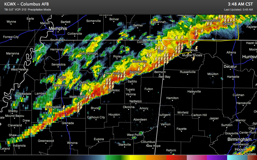
A line of intense storms is into Northwest Alabama this hour. It now is south of Murfreesboro and Cookeville in Tennessee. It extends on into Mississippi, on to near New Albany and eventually Cleveland.
A Severe Thunderstorm Warning is in effect for Lauderdale and Colbert Counties just west of Florence and Muscle Shoals, with an accompanying warning in southern Tennessee ahead of the same activity. The line has been bowing out in that area, indicating the potential of winds of 50-60 mph. Quarter sized hail was reported at Waterloo in Lauderdale County in the past couple of minutes.
A tornado watch remains in effect until 5 a.m. for Northwest Alabama.
The line of storm is about 10-15 miles wide. Lots and lots of lightning all along it. Several indications of hail, especially in Northeast Mississippi.
It is moving southeast at 15-20 mph. At this rate, it should reach northwestern Marion County around 4:45 and northwestern Walker County around 7 a.m.
The potential is there for damaging winds with the squall line as it sinks slowly southeast. Hail will be a threat as well. There is sufficient spin in the low levels of the atmosphere for spin up tornadoes as well. While these won’t be the big April 27th type tornadoes, they can crush or blow over a mobile home and knock down large trees and damage homes.
Please continue to monitor the line as it pushes southeast and be in a safe place as it passes. Heavy rain and lightning will also be dangers with the storms.
The threat for severe weather will continue as the line pushes southeast through the morning hours. The SPC has the northern two thirds of Alabama (except for the Northwest corner of the state) in its standard slight risk severe weather outlook for later today starting at 6 a.m. ahead of the line of storms and cold front.
Current thinking on timing for the line to reach the I-59 corridor in the Birmingham area is around 9:30-10:30 a.m. It will push on further southeast into the early afternoon.
The area southeast of the I-59 corridor could be at higher risk for severe weather as that area will undergo some heating and more destabilization before the storms arrive during the late morning and early afternoon.
A new tornado watch will be issued around 4 or 4:30 for areas southeast of the current one.



