


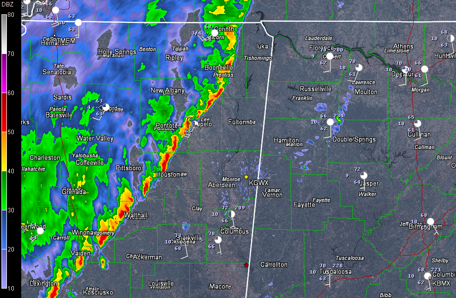
A line of heavy showers (low topped convection) is approaching Northwest Alabama at this time. It is the leftover activity from last evening’s severe weather to the northwest. It has run out of fuel (instability) as it has progressed southeastward.
At 9:40, it extends from near SAvannah, TN to Booneville, MS to Tupelo to west of Starkville.
The showers should reach Franklin County around 10:15-10:30, Lamar County around 11 a.m. and Pickens County around noon.
It has not really fallen apart as predicted by the RPM model, and the northern segment has actually intensified a little. Still, there isn’t even any thunder, with tops around 20,000-25,000 feet. Can’t rule out some isolated thunder, but there isn’t any instability ahead of the line right now either. The intensification is probably due to strong upper level winds over the Missouri bootheel that are rotating through the base of the trough to the west, spinning up some small vortexes along the line of showers.
In fact, there is a good bit of low level wind up at about 5,000 feet. At the surface, winds are gusty over northern Mississippi, as high as 24 mph at Corinth.
Ahead of the line, the winds are actually slightly backed (coming from the southeast) over eastern Mississippi and Central Alabama. If we had stronger updrafts, we might have had enough low level shear for spinning storms.
Clouds are pretty thick over Alabama, with just a few breaks in the clouds. Accordingly, temperatures are only slowly rising into the lower 70s. Some cooler, drier air is over eastern Alabama, thanks to the big ridge of high pressure to our northeast. This will limit highs over northeastern and eastern sections to the middle 70s. The I-65 corridor will flirt with 80F depending on sun amounts, with upper 70s common elsewhere.
As temperatures rise, the atmosphere might squeeze out enough instability to fuel showers and storms that will form over Mississippi this afternoon and push into Alabama ahead of the cold front late in the day into the overnight. The strong upper level winds associated with the trough will allow any strong updrafts that form to intensify and there will be some low level shear as well. For this reason, the SPC has a slight risk severe weather outlook for northwestern Alabama this afternoon and tonight. The risk area is defined as north of a line from Millport to Jasper to Oneonta to near Fort Payne. The main threat is damaging winds, but there is an outside chance of a couple of tornadoes.
The activity will push through the area overnight in the form of a line of showers and storms. The cold front will reach the I-59 corridor after midnight. By morning, the showers should be near I-85. SKies will clear on Monday as slightly cooler, drier air feeds into the area.



