


DRY: An unusually dry weather pattern will persist across Alabama through next week thanks to an upper air ridge, keeping the main rain/storm producers well to the west and north. Expect partly to mostly sunny days and fair nights.
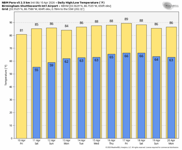
Afternoons will be warmer under the ridge; afternoon highs will be in the 80s for at least the next ten days. Some South Alabama communities could reach the low 90s over the latter half of next next week.
Out in the longer range, global models do suggest we could see a few days with rain chances the week of April 20-24… See the video briefing for maps, graphics, and more details.
DROUGHT MONITOR: The new drought monitor released yesterday (this product is released once every week on Thursdays) continues to show 77 percent of Alabama in some type of drought. These drought conditions will intensity over the next ten days as the dry pattern continues.

ON THIS DATE IN 1979: A widespread and destructive outbreak of severe weather impacted areas near the Red River between Oklahoma and Texas. Hardest hit were the communities of Vernon, Texas; Lawton, Oklahoma; and Wichita Falls, Texas. The F4 Vernon tornado struck southern and eastern parts of the city, destroying several residential blocks and killing 11 people. An F3 tornado spun up in Lawton, destroying 167 buildings and killing 3 people.
The most significant tornado of the day was an F4 tornado that began east-northeast of Holliday, Texas, and moved east-northeast into Wichita Falls, taking a 8 mile course through densely populated areas of the city and destroying over two thousand homes across several neighborhoods. The tornado spanned as wide as 1.5 miles across during its passage through the city. At least 45 people were killed in Wichita Falls and nearly 1,800 people were injured, ranking the tornado among the deadliest in Texas history.
Look for the next video briefing here by 3:00 this afternoon… enjoy the day!



