


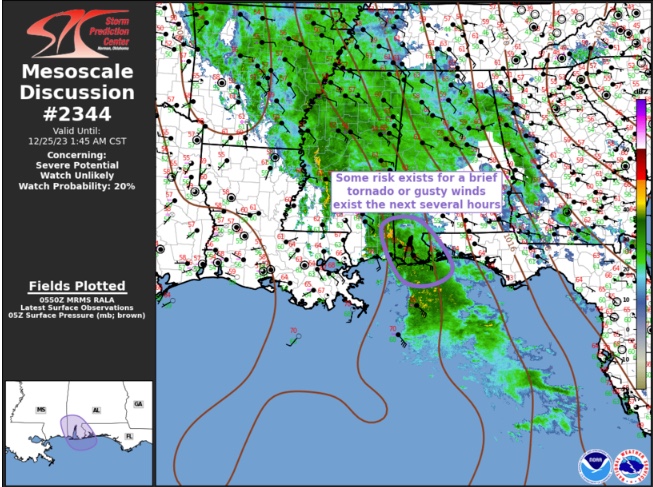
The SPC has issued a mesoscale convective discussion for the Central Gulf Coast tonight for the possible of severe weather.
They put the chance of a watch being issued at only 20 percent. But there is a chance of damaging wind gusts and a brief tornado or two over far Southwest Alabama.
Here is the full text of the product:
Mesoscale Discussion 2344
NWS Storm Prediction Center Norman OK
1151 PM CST Sun Dec 24 2023
Areas affected…Central Gulf Coast
Concerning…Severe potential…Watch unlikely
Valid 250551Z – 250745Z
Probability of Watch Issuance…20 percent
SUMMARY…Gusty winds and perhaps a brief tornado are possible with
the most robust convection early this morning.
DISCUSSION…Negative-tilt upper trough is advancing northeast
across the lower MS Delta region this evening. An extensive region
of convection continues ahead of this feature extending from the
northern Gulf Basin, northwest across southeast MS/southern AL.
Boundary-layer air mass has been slow to modify inland, but surface
dew points have crept into the lower 60s along the immediate coast
with a 66F dew point now observed at Gulf Shores. Latest radar data
suggests a few updrafts, embedded within this larger corridor of
convection, are exhibiting some rotation, albeit mostly weak. These
circulations may be enhanced somewhat due to an approaching MCV-like
feature located about 50 mi south of MOB. Forecast soundings suggest
near-surface based convection is likely with 64F dew points,
although instability will remain poor. Even so, some risk for a
brief tornado or gusty winds may be noted with the strongest
convection as it moves inland.
..Darrow/Guyer.. 12/25/2023
…Please see www.spc.noaa.gov for graphic product…



