


Temperatures Remain Well Above Normal On Christmas Day
We continue in this mild and dry weather pattern across Central Alabama which will turn out to be a fantastic Christmas Day. Skies will have more sunshine than clouds and the afternoon highs will top out in the mid to upper 60s across the area. Wouldn’t be surprised if one or two spots hit the lower 70s like on Tuesday.
Staying Dry Through The End Of The Holiday Work Week
Clouds will be on the increase on Thursday, but all signs continue to point to a dry and mild day once again. Afternoon highs will be in the mid to upper 60s. On Friday, there will be plenty of clouds with only a few rays of sunshine making it through at times. We will continue to stay dry across the area with highs reaching in the mid-60s to the lower 70s.
Rain Chances Ramp Up For The Central Alabama Weekend
A surface low will start off the day on Saturday over the southwestern parts of Kansas and will be moving northeast through the day. A cold front will be trailing down into the southeast from the low bringing rain chances into the forecast for late Saturday through much of the day on Sunday. There may be a clap of thunder or two thrown in, but this looks to become more of a decent rainmaker. Highs will be in the upper 60s to the lower 70s.
As those better dynamics with the low as it moves into northeastern parts of Wisconsin by midday on Sunday, the cold front will continue to move across Central Alabama bringing rain to all of the area. Amounts of 1/2-inch to 1 3/4 inches are possible with the higher amounts over the northwestern parts of the area. With those dynamics that far away, no severe weather is expected even though a few claps of thunder may be possible. Highs will be in the lower 60s to the lower 70s.
Cooler To Start Next Week
As we start into the transition week from 2019 to 2020, Monday looks to be a cooler day than what we will see for the rest of this holiday week. There may be a brief window of where showers will be pushing out of the state very early in the morning, but clouds look to be on the decrease throughout the day. Highs will be in the lower 50s to the lower 60s. Skies will be mostly clear on Tuesday with highs in the 50s.
Voodoo Land
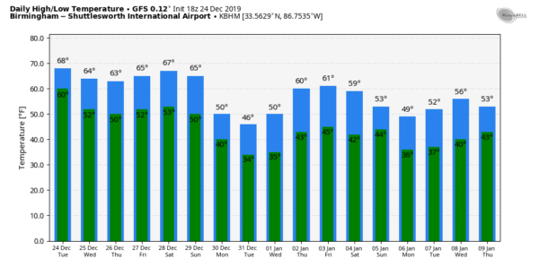
After Tuesday, we continue to see dry weather through much of the rest of the week, but our next rainmaker looks to move into the area around midday on Thursday in the northwestern parts. By morning hours on Friday, all of Central Alabama looks to receive a good supply of rain. The action doesn’t look to leave the area until late Saturday evening. Temperatures for the next 15 days look to stay mainly in the 50s and 60s for highs with lows staying above freezing. But as you know, this is out in “Voodoo Land,” so these outlooks could and probably will change.
On This Day In Weather History
2006 – Severe thunderstorms produced four tornadoes in Florida. Columbia, Pasco, Lake, and Volusia counties were hardest hit, including the Daytona Beach area. A tornado generated considerable damage on the campus of Embry-Riddle Aeronautical University, delaying the start of the spring semester (Orlando Business Journal).
Beach Forecast
Get the latest weather and rip current forecasts for the beaches from Bay St. Louis, MS, to Panama City Beach, FL, on our Beach Forecast Center page. There, you can select the forecast of the region that you are interested in.
Advertise With The Blog!
After a record-setting 2018 with nearly 20 million page views, AlabamaWx.com is already well on its way to another great year as we’ve just topped 16.6 million page views so far in 2019! Don’t miss out! We can customize a creative, flexible and affordable package that will suit your organization’s needs. Contact Bill Murray at (205) 687-0782.
E-Forecast
Get the Alabama Wx Weather Blog’s Seven-Day Forecast delivered directly to your inbox by email twice daily. It is the most detailed weather forecast available in Central Alabama. Subscribe here… It’s free!
Connect With The Blog On Social Media
You can find the AlabamaWx Weather Blog on the major social media networks:
Facebook
Twitter
Instagram
WeatherBrains
Don’t forget you can listen to our weekly 90 minute netcast anytime on the web at WeatherBrains.com or on Apple Podcasts, Stitcher, or Spotify. This is the show all about weather featuring many familiar voices, including the meteorologists at ABC 33/40.



