


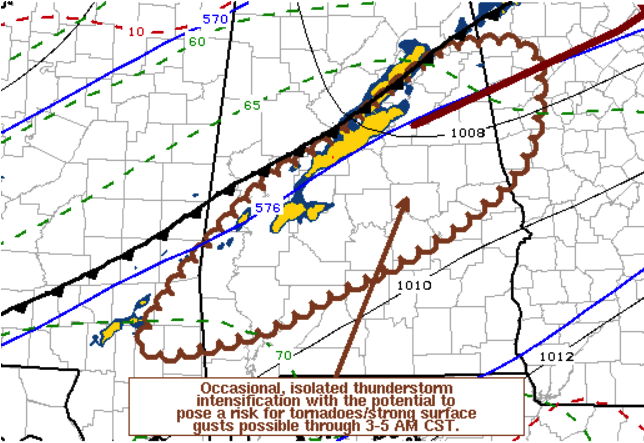
The threat for severe storms continue to slowly dwindle as we get later into the morning and the better dynamics continue moving off further to the northwest. However, isolated thunderstorm intensification with the potential of a brief tornado or damaging winds will remain possible for the next couple of hours. Here is the text from the discussion:
SUMMARY… A substantive further increase in severe weather potential appears unlikely, but isolated, occasional thunderstorm intensification, which could pose potential to produce a tornado or locally damaging wind gusts, remains possible through 3-5 AM CST.
DISCUSSION… Much of the Southeast remains under the influence of larger-scale mid/upper subtropical ridging, and recent warm sector thunderstorm development is struggling to maintain substantive intensity while remaining confined to a narrow corridor immediately ahead of an initial weak cold frontal zone. With the primary surface frontal wave development currently ongoing near/east of the northern Mid-Atlantic coast region, the tail end of the core of stronger (50+ kt around 850 mb) southwesterly low-level wind fields are in the process of shifting northeastward to the lee of the southern Appalachians. As this continues, a gradual weakening of low-level flow across the eastern Gulf Coast states appears likely through daybreak.
However, in the presence of seasonably high moisture content (including surface dew points near 70F), low-level hodographs immediately ahead of the front may remain sizable with at least some clockwise curvature through the 09-11Z time frame. This may continue to support a conditional risk for the evolution of supercell structures with the potential to produce tornadoes, as the front gradually advances southeastward across northwestern Georgia, central Alabama and southeastern Mississippi, in tandem with perhaps some suppression of the ridging at mid-levels.



