


The forecast remains pretty consistent this time of year and for today, tomorrow, and Sunday, the forecast remains hot and humid with temperatures in the low 90s and heat index values near or just over 100°. Each day about midday and through the afternoon and evening hours, scattered showers and storms pop-up and meander about the Alabama landscape. We are seeing these over North Alabama as we see each day, these will continue to increase in coverage and intensity the rest of today.
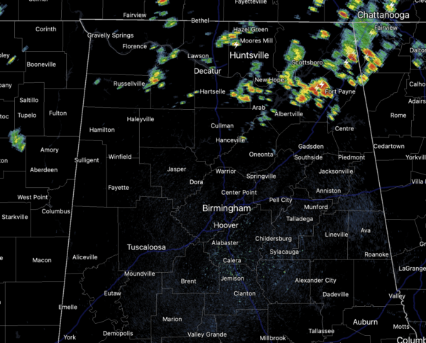
As we have seen in recent days, some storms will be strong and locally severe at times with gusty winds and tremendous amounts of dangerous lightning. Also, they produce torrential downpours, which have and could result in areas isolated flash flooding. Most of the showers and storms will come from 12PM-10PM daily with the odds of any one spot getting wet reach day are in the 40-60 percent range. Again, these storms are completely random, and you just have to watch radar trends when they start developing. Coverage of showers and storms should become a little higher late Sunday, especially over the southeast part of the state, as deeper tropical moisture spreads northward in association with Fred
LATEST ON FRED: The center of Tropical Depression Fred was located near latitude 22.3 North, longitude 78.4 West. The depression is moving toward the west-northwest near 12 mph, and this general motion is expected to continue today. A turn toward the northwest is expected tonight or Saturday. On the forecast track, Fred is expected to move along or near the north coast of central Cuba through tonight, be near the Florida Keys on Saturday, and move near or west of the west coast of the Florida peninsula Saturday night and Sunday. By Monday, the system looks to be moving onshore near or just east of Panama City, then the remnant low working into Central Alabama Monday night and into Tuesday.
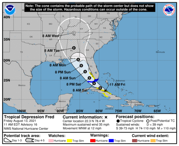
Maximum sustained winds are near 35 mph with higher gusts. Little change in strength is expected today. After that, slow strengthening is expected, and Fred could become a tropical storm again tonight or Saturday. The minimum central pressure estimated from surface observations and Air Force Reserve Hurricane Hunter aircraft data is 1013 mb (29.92 inches).
Confidence is high Fred won’t become a hurricane in the Gulf due to interaction with the Florida peninsula and shear. The main impact will be rip currents and lots of rain.There will be a high danger of rip currents along the entire central Gulf Coast (Gulf Shores to Panama City Beach) Sunday and Monday. Expect double red flags in many areas, which means the waters are closed.
The heaviest rain from Fred will be along and east of the circulation center and will be impacting the Florida peninsula, Georgia, and the Carolinas. But, the system will pull deeper tropical moisture into Alabama next week, and we will see an increase in the number of showers and storms. With any landfalling tropical system, A few isolated tornadoes will be possible across the Florida peninsula Sunday, on the east side of Fred. And these could expand in South Georgia as well as far Southeast Alabama Monday, but again, this threat will depend on the track of the center of circulation.
Remember this forecast CAN change some of the coming days, so pay attention to any updates.
SOON TO BE GRACE: The disturbance was centered near latitude 15.3 North, longitude 49.3 West. The system is moving toward the west near 21 mph, and this general motion with a gradual decrease in forward speed is expected into early next week. On the forecast track, the system is expected to approach the Leeward Islands on Saturday, move over the Leeward Islands Saturday night and Sunday, and then be near the Virgin Islands and Puerto Rico Sunday night and Monday.
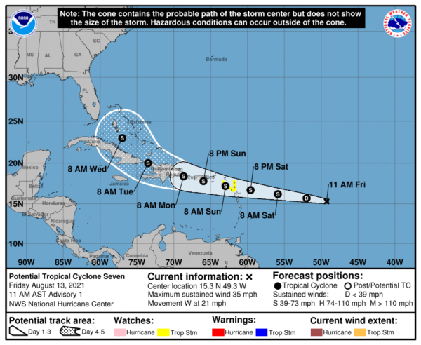
Maximum sustained winds are near 35 mph with higher gusts. Gradual strengthening is forecast during the next couple of days,
and the disturbance is expected to become a tropical depression tonight and a tropical storm by Saturday. The estimated minimum central pressure is 1010 mb (29.83 inches).
NEXT WEEK: The rain coverage on Monday and Tuesday will depend on the Fred’s overall track, but due to deep tropical moisture being in place these two days, the forecast features numerous showers and storms. For the rest of the week, routine August weather with a partly sunny sky and scattered, mostly afternoon and evening showers and thunderstorms. Highs will be mostly in the 80s and 90s across the state through the week.
BEACH FORECAST CENTER: Get the latest weather and rip current forecasts for the beaches from Fort Morgan to Panama City on our Beach Forecast Center page. There, you can select the forecast of the region that you are interested in visiting.
CONTIGUOUS TEMPERATURE EXTREMES: Over the last 24 hours, the highest observation was 117F at Stovepipe Wells, CA. The lowest observation was 32F at Peter Sinks, UT.



