


Click to enlarge
We continue to monitor the happenings to the west of Alabama tonight, both out of concern for our friends in the areas where severe weather is occurring, and to discern signs that might help understand the timing and intensity of the storms in Alabama tomorrow.
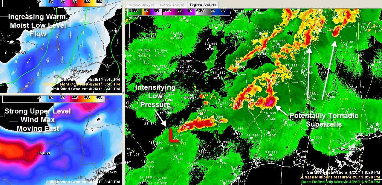
Storms are moving across northern Mississippi at this hour. The strongest is crossing US-78 near Holly Springs. It is moving toward Corinth. The overall intensity may have diminished just a tad in the last hour, but that storm is still capable of producing large hail, damaging winds and a tornado. Other storms are approaching Tunica and severe thunderstorm and tornado warnings are in effect for them.
Storms in eastern Texas and northwestern Louisiana will continue pushing east northeast toward the Mississippi River Delta. The NWS Shreveport is reporting several minor injuries in southern Bossier Parrish in Northwest Louisiana from a tornado. An oil rig was knocked over. Bossier is the Parrish just east of Shreveport.
The weakening trend in the northern Mississippi storms has been due to less unstable air the further east you go That is going to change overnight as lots of warm, moist, unstable is transported northward on a strong low level wind pattern overnight. More storms could fire over northern Mississippi and move east northeast as well.
All of these could affect Northwest Alabama during the pre-dawn hours.
The arrival of these storms overnight in Alabama, if it occurs, is not unexpected. I am afraid though that is does not mitigate the situation tomorrow.
The surface low is south of Dallas tonight and has already deepened to 992 millibars. A strong wind max in the upper atmosphere is moving across North Central Texas. It will intensify the low and help storms to intensify over the Arklatex and Mid-South this evening, into western Tennessee. As the low moves northeast tomorrow, we will be in an increasingly rich warm sector with plenty of instability. The presence of a cap in the morning could make things worse by keeping a lid on the boil until it boils over.
Between 7 a.m. and noon tomorrow, you will see strong storms fire over northern Mississippi again and they will edge into Northwest Alabama around lunchtime. By that time, the cap will start to erode, and storms will start to fire over Central and eastern Mississippi. We will probably remain high and dry in Central Alabama through lunchtime. But thunderstorms will start to go off like firecrackers over West Central Alabama between noon and 2 p.m. and work their way east and southeast. These storms will be dangerous, with good instability and strong wind fields. The various severe weather parameters are very high tomorrow and tornadoes are a good possibility, including the chance for long tracked and strong tornadoes.
We don’t say any of this to scare anyone, just to make sure that everyone is aware of the situation tomorrow and keeps the possibility in their minds in case it becomes a reality. Stay in constant earshot of a reliable source of watch and warning information through tomorrow and know where you will go at any point in your day in case a warning is issued.
IRONIC NOTE
From a forecaster at the NWS Little Rock just a minute ago on the NWS Chat: Storm surveys for last night’s storms: Vilonia area was rated EF2, neither the beginning nor ending point has been found. Sunshine area in Garland County was rated EF2. Surrey Rd. area northwest of Fountain Lake in Garland County was rated EF3. Hot Springs Village was rated EF1. Sorry I can’t send out a Public Information Statement. All of the workstations are tied up with severe weather.



