


An all new edition of the ABC 33/40 Weather Xtreme video is available in the player on the right sidebar of the blog. You can subscribe to the Weather Xtreme video on iTunes by clicking here.
RADAR CHECK: Pretty quiet at mid-afternoon… very little rain over the northern half of Alabama. However, we will deal with one more round of rain late tonight and early tomorrow before we can finally see a big improvement in our weather.
High resolution model data suggests the main window for rain will come from about 10:00 tonight through 8:00 a.m. tomorrow, so for the Christmas parades this evening the weather won’t be too bad with only scattered light rain or drizzle.
TEMPS: Another big spread today with 30s over Northwest Alabama, and temperatures close to 60 near Auburn/Opelika…
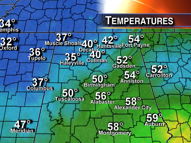
But the air northwest of the state remains very cold, and some of that will drop south into the state after midnight.
WINTER WEATHER ADVISORY FAR NORTH ALABAMA LATE TONIGHT/EARLY TOMORROW: The NWS has issued a “winter weather advisory” for 8 counties in far North Alabama…
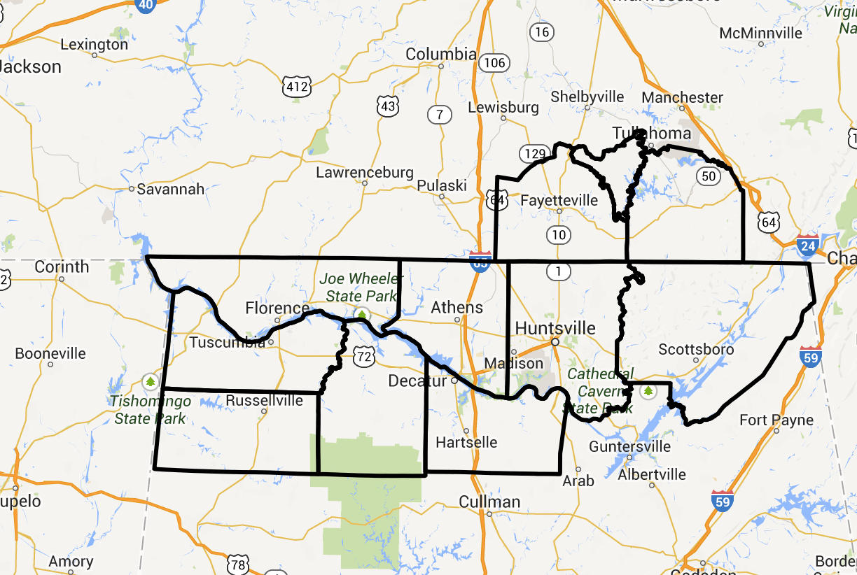
Temperatures in this part of the state will drop down toward the freezing mark in the 2:00-5:00 a.m. time frame, and there could be a tough of light freezing rain, or maybe even a snow flake or two. This could lead to some patchy bridge icing in the zone from Muscle Shoals over to Huntsville. Don’t think it will be an especially major problem, but if you are in that part of the state, or traveling there, just be aware of the potential.
If there is any bridge icing up that way, temperatures should rise above freezing by 9:00 a.m. with improving conditions by then.
WINDY AND COLD TOMORROW: The rain will end early in the day, but expect a windy and cold Tuesday. We will have a hard time reaching the mid 40s, and a north wind of 10-20 mph will make it feel colder. The morning will be cloudy, but we just might see a peek or two of sunshine tomorrow afternoon as drier air begins to move into our state.
SUNSHINE, FINALLY: Looks like we can promise a good supply of sunshine Wednesday and Thursday. Mornings will be cold with lows in the 20s; the high Wednesday will be in the 51-54 degree range, but Thursday will be colder with a high in the upper 40s.
Friday will be dry as well, but clouds will move in late in the day ahead of the next storm system that will impact Alabama.
OUR WEEKEND: Rain is likely Saturday as a surface low spins up near the northwest corner of Alabama, supported by a deep upper trough. The rain could arrive late Friday night.
Parts of the state could be in the warm sector of the storm, meaning some risk of thunderstorms. But, instability values are basically non existent so severe storms should not be an issue. Rain amounts of about one inch are likely before the rain ends late Saturday.
Sunday will be mostly sunny, but windy and cold with a high in the 40s.
THE LAND OF VOODOO: The 12 GFS is trying to bring down another bitterly cold airmass into the U.S. right before Christmas. Not a forecast, but just something to watch for now. See the Weather Xtreme video for the maps, graphics, and details.
WEATHER BRAINS: Don’t forget you can listen to our weekly 90 minute netcast anytime on the web, or on iTunes. This is the show all about weather featuring many familiar voices, including our meteorologists here at ABC 33/40.Tonight’s Guest WeatherBrain is Lourdes Aviles, an Associate Professor at Plymouth State University in Plymouth, NH. She is the author of Taken by Storm, a Social and Meteorological History of the Great New England Hurricane of 1938. The show begins at 8:30p CT, and you can watch it on “James Spann 24/7? on cable systems around the state, or on the web here.
CONNECT: You can find me on all of the major social networks…
Facebook
Twitter
Google Plus
Instagram
I had a great time today visiting with students at Alexander City Middle School…. be looking for the next Weather Xtreme video here by 7:00 a.m. tomorrow…



