


**No Weather Xtreme video this morning… I will produce one this afternoon… trying to save the voice!**
IMPROVING WEATHER TODAY: In the wake of the nasty squall line that produced lots of tree and power line damage across our state last night, drier air returns to the state today with a clearing sky and a high in the mid 60s.
SUNNY SATURDAY: We are still expecting a delightful day to kick off the weekend… lots of sunshine tomorrow with a chilly morning but a very nice warm-up. We will rise from the mid to upper 30s at daybreak to close to 70 degrees by mid-afternoon. There might even be a touch of frost in a few spots early in the day.
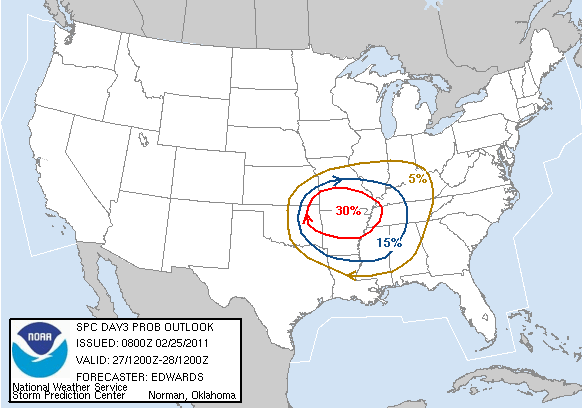
MORE QUICK CHANGES: Sunday will be breezy and rather balmy with afternoon highs rising into the mid to upper 70s, and with an increase in Gulf moisture, there could be a few passing showers during the day. To the west, yet another severe weather outbreak will likely begin Sunday night… below is the SPC day 3 severe weather outlook, valid from 6:00 a.m. Sunday through 6:00 a.m. Monday…
The global models continue to hint the main severe weather risk for Alabama could very well come from 3:00 a.m. until 1:00 p.m. Monday. Below is the GFS output valid at 12:00 noon CST Monday…
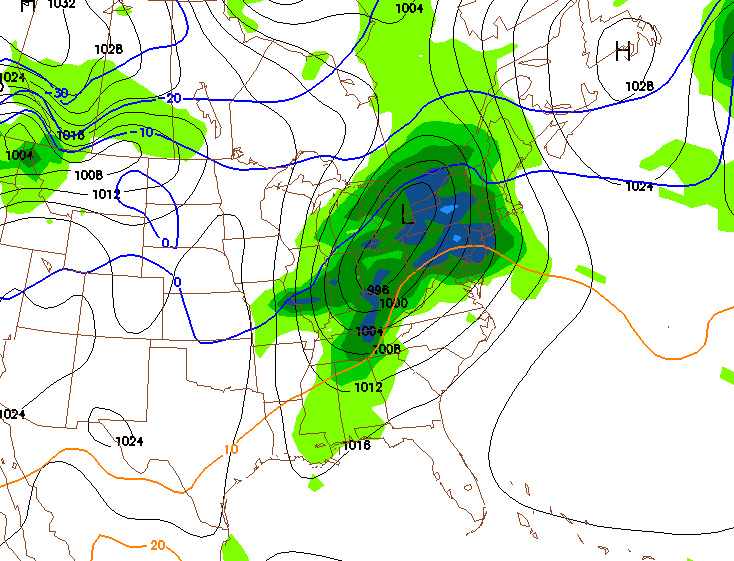
Quite frankly, at this point there are more questions than answers about this late Sunday night/Monday event. But, with the main surface low so far to the north, it sure looks like another squall line/QLCS type event with the main threat being damaging straight line winds here in Alabama Monday morning. And, hopefully with limited instability at that hour (most models suggest SBCAPE values will be less than 500 j/kg), it will limit the overall threat. We will dig much deeper into the situation after the 12Z model runs come in and we have had a chance to grab a decent nap!
REST OF NEXT WEEK: The weather looks nice and calm Tuesday through Thursday, with mostly sunny pleasant days and clear cool nights. The 00Z GFS is not as cool as recent runs, suggesting lows will be in the low 40s. Still, I would not be shocked if some of the normally colder valleys made a run at the freezing mark on one or two mornings.
LAST NIGHT’S STORMS: Below is a graphic of some of the wind damage reports received by the NWS Birmingham…
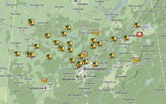
Seems like some of the most widespread wind damage was across Marion, Lamar, Fayette, Winston, and Walker Counties of Northwest Alabama. There were a few tornado warnings issued, but I am pretty sure most of the damage was due to damaging straight line winds. NWS survey teams will be out to take a look later today.
WEATHER BRAINS: Don’t forget you can listen to our weekly 30 minute netcast anytime on the web, or on iTunes. This is the show all about weather featuring many familiar voices, including our meteorologists here at ABC 33/40.
FOLLOW ALONG: Here are our weather team Twitter accounts….
| James Spann | Jason Simpson | Ashley Brand |
| J. B. Elliott | Bill Murray | Brian Peters |
| Dr. Tim Coleman | WeatherBrains Podcast | E-Warn (AL wx watches/warnings) |
Look for a Weather Xtreme video at some point this afternoon with a full look at the severe weather threat for Monday… stay tuned!



