Daily Weather Briefing
Saturday, November 21, 2026
ALABAMA THIS MORNING
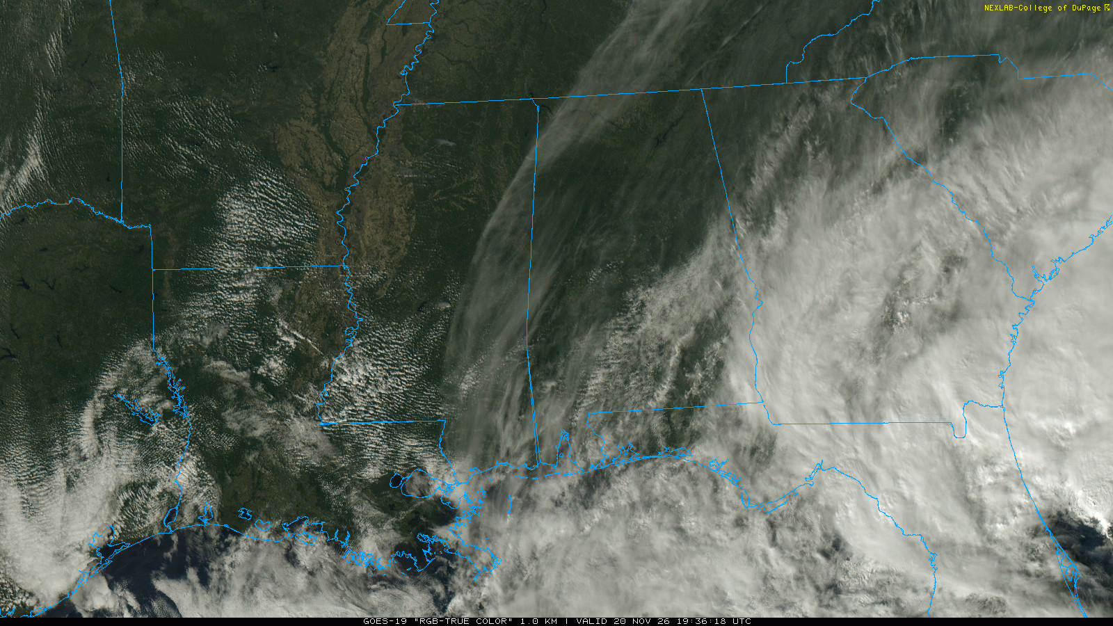
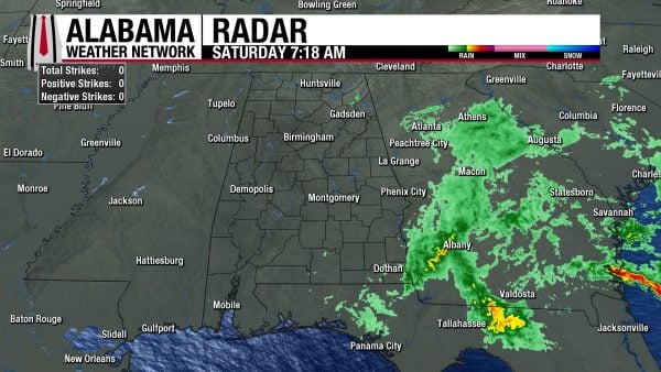
Alabama hosts a wide range of temperatures this morning, with northwest Alabama in the mid 40s, the rest of the north in the low to mid 50s, west-central Alabama in the low 50s, the southwest in the upper 50s, and east-central and southeast Alabama in the upper 50s to low 60s. A few showers are active in the southeast corner of the state, as well as in south DeKalb County. Skies are mostly cloudy statewide.
ALABAMA 7 DAY FORECAST
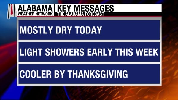
Today will be a mostly dry day statewide. A cold front will approach Alabama Sunday and move through the state through Tuesday, bringing a low chance of light showers with it. Tuesday should be mostly dry again, then an upper-level trough moves through Alabama on Wednesday, increasing rain chances again. Alabama will cool off and dry quickly by Thursday, so the holiday and Friday will have just below normal conditions for this time of year.
MOSTLY DRY SATURDAY – Nov 21
Besides a few sprinkles possible in the south today, Alabama should be mostly dry. Skies will be partly to mostly cloudy statewide, but the northwest has a better chance of clear skies. Highs will rise into the mid 60s to low 70s statewide, with the lower portion of that range more likely in eastern south-central Alabama.
COLD FRONT PASSAGE BRINGS LIGHT RAIN SUNDAY THROUGH TUESDAY – Nov 22-24
A cold front associated with a surface low in Canada will approach Alabama Sunday and sweep through the state early this week. Low rain chances exist for the state each day, but any showers that develop will be light, leading to low rainfall totals. Tomorrow will start with lows in the upper 40s to mid 50s statewide, then warm to the low to mid 70s in the afternoon. Monday mornings will see temperatures in the low to mid 50s, and highs will reach the low to mid 60s north and low to mid 70s across the southern two-thirds of the state as cooler air begins to filter into Alabama behind the front. Tuesday’s lows will range from the low to mid 40s north, mid to upper 40s centrally, to the upper 40s to low 50s in the south. Highs will be in the cool low 60s north and upper 60s to low 70s in central and south Alabama.
SHOWERS POSSIBLE WEDNESDAY – Nov 25
More light rain is expected on Wednesday as an upper-level trough passes over Alabama, but rainfall totals will still be unimpressive. Lows on Wednesday will be in the low 40s north and mid 50s south, and highs will be in the mid 50s north, upper 50s to low 60s centrally and in south Alabama.
COLD THURSDAY AND FRIDAY – Nov 26-27
A colder shot of air follows the trough into the state on Thursday and Friday, creating cold and dry conditions for the holiday. Thanksgiving Day will start with temperatures in the mid 30s north, upper 30s to low 40s centrally, and mid 40s south. Then highs will find their way into the mid to upper 50s north and upper 50s to low 60s in the southern two-thirds of the state. Friday morning will be even cooler, with the low 30s to low 40s stretching north to south. Highs will be similar to Thursday’s.
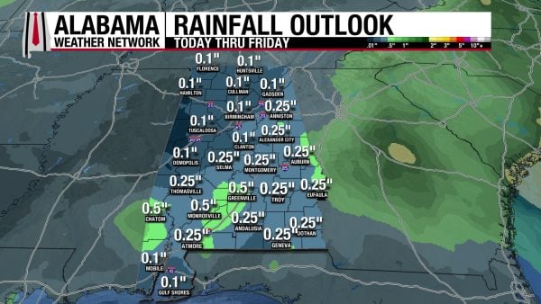
RAINFALL OUTLOOK
Over the next week, Alabama will see rainfall totals between a tenth and a half an inch, with half-inch totals sporadic. This is because the atmosphere is quite dry, so despite our multiple days of rainfall chances, there is little moisture for the systems to squeeze out of the atmosphere.
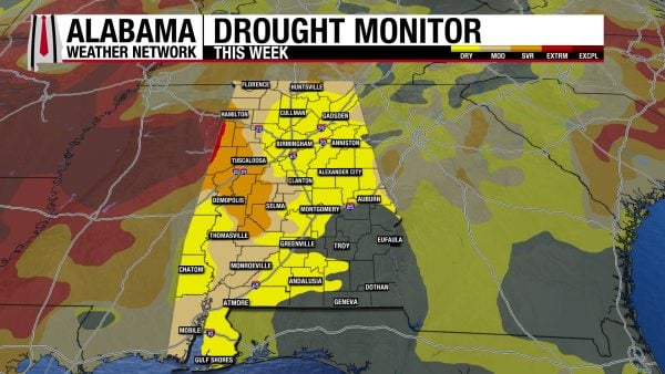
WORSENING DROUGHT
Alabama’s drought is worsening as we stay mostly dry each week. This week, 0.31% of the state is under Extreme Drought (D3) conditions, while last week, no part of Alabama was in this category. Our Severe Drought (D2) conditions have worsened as well, as 12% of the state is experiencing them now, compared to 9.04% last week. Also, almost half (48.70%) of the state is in Abnormally Dry (D0) conditions, compared to 37. 36% last week. Unfortunately, relief is not to be found as we will be mostly dry over the next week.
FOOTBALL FORECAST
ALABAMA VS. CHATTANOOGA
Alabama hosts Chattanooga today at Bryant-Denny Stadium at 1:00 p.m. CST. Expect a partly sunny sky with temperatures in the low to mid 70s.
AUBURN VS. SAMFORD
Auburn is also at home, playing Samford at Jordan-Hare Stadium at 2:30 p.m. CST today. The sky will be mostly cloudy, and a small risk of a few sprinkles exists during the game. Temperatures will be in the low 70s at kickoff and fall into the upper 60s during the second half.
OTHER GAMES
For other games, most of the Deep South will be rain-free today and tonight. Most of the rain will be southeast of Alabama.
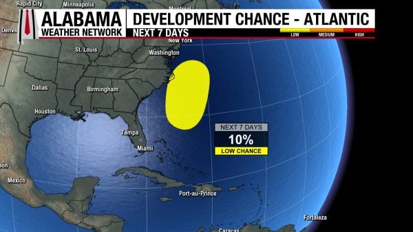
TROPICAL UPDATE
A non-tropical low-pressure system sits off the coast of northeast Florida this morning. Chances for subtropical or tropical development continue to decrease as conditions for development of these kinds of systems look to be unfavorable over the coming days. There is only a 10% chance the system becomes something tropical this week. However, the system is still robust and will bring strong, gusty winds, heavy rains, flash flooding potential, and coastal flooding to the Southeast and Mid-Atlantic coasts this weekend and early next week.
The Pacific remains quiet.
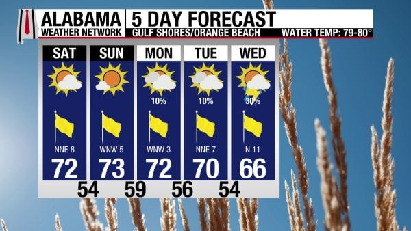
BETTER BEACH CONDITIONS THIS WEEKEND
After a windy week with rough surf, Alabama’s Gulf Coast gets a break from the wind this weekend. Today, winds will blow from the northeast at 5 to 10 mph, skies will be mostly sunny, and the high will be in the low 70s. The rip current risk is Moderate, and the surf height is between 2 and 3 feet. Winds settle further tomorrow, as does the rip current risk. Next week features low rain chances through midweek.
TODAY IN WEATHER HISTORY
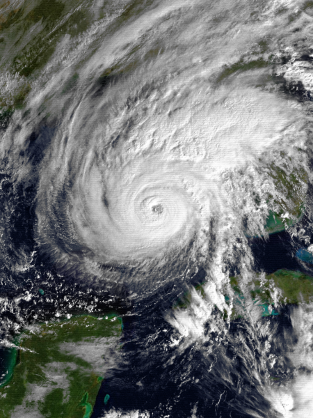
November 21, 1985 – Hurricane Kate
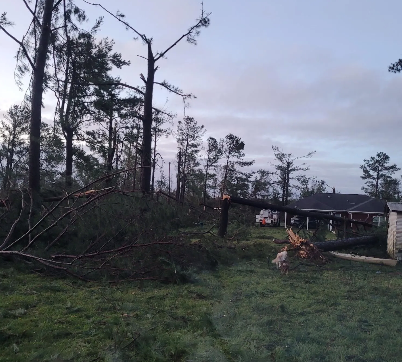
The 1985 Atlantic hurricane season delivered one final and extraordinary blow to the United States when Hurricane Kate roared ashore near Mexico Beach, Florida, on the afternoon of November 21. With sustained winds near 100 mph, Kate struck the Florida Panhandle as a Category 2 hurricane, becoming the latest hurricane on record to make landfall in the contiguous United States. Its arrival was especially remarkable because the official Atlantic hurricane season was only nine days from ending, and the northern Gulf of Mexico was already transitioning toward winter. Kate had developed northeast of the Virgin Islands on November 15, crossed Cuba on November 19, and intensified rapidly over the eastern Gulf of Mexico. On November 20, it reached Category 3 strength with sustained winds of 120 mph and a central pressure of 954 millibars, becoming the third major hurricane of the season. Although increasing wind shear weakened Kate before landfall, it remained an exceptionally dangerous storm. For residents of the Florida Panhandle, the timing was particularly unsettling. Just three months earlier, Hurricane Elena had threatened the same coastline, triggering widespread evacuations before ultimately striking Mississippi. Now, with Thanksgiving only a week away, another hurricane was approaching.
Kate’s most destructive effects were concentrated along Florida’s northeastern Gulf Coast, where powerful winds, storm surge, and heavy rainfall combined to batter coastal communities. Storm tides reached approximately 11 feet above normal in some locations, flooding low-lying areas and damaging waterfront structures. Sections of U.S. Highways 90 and 98 were washed out or severely damaged, complicating travel and emergency response. In Wakulla County, more than 150 homes were left uninhabitable, while communities around St. Marks, Panacea, and Shell Point suffered substantial coastal flooding and property damage. Panama City recorded more than eight inches of rainfall as Kate moved inland, and the combination of torrential rain and strong winds created dangerous conditions across the Panhandle. Trees fell onto houses, utility poles snapped, and debris blocked streets and highways.
Tallahassee experienced some of the hurricane’s most widespread wind damage. Although the city lies approximately 40 miles inland from the Gulf Coast, Kate’s powerful circulation carried destructive winds well away from the shoreline. An estimated 90 percent of the city lost electrical service as thousands of trees toppled across power lines, streets, and homes. Some of the damage suggested that localized wind gusts may have exceeded 100 mph, particularly where falling trees and structural damage were concentrated. Tallahassee’s extensive canopy of mature oaks and pines became a major vulnerability, with entire neighborhoods blocked by fallen timber. Florida State University and Florida A&M University experienced disruptions, while residents faced the difficult task of clearing debris and repairing damaged property. As Kate accelerated northeastward through Georgia, its winds weakened, but heavy rainfall continued to produce flooding across portions of Georgia and the Carolinas. Agricultural losses were substantial, particularly in the timber and pecan industries, where high winds damaged or destroyed trees that would require years to replace. The storm’s effects extended far beyond the immediate landfall area, demonstrating how a late-season hurricane could create a multistate disaster even after weakening over land.
By the time Kate’s remnants moved away from the eastern United States, the hurricane had caused five deaths and approximately $300 million in damage, according to contemporary estimates. It was the sixth hurricane to strike the United States during the unusually active 1985 season, a year that also brought major hurricane threats from Elena and Gloria. Kate’s November 21 landfall remains an extraordinary milestone in American hurricane history, illustrating how favorable atmospheric conditions can occasionally sustain a powerful tropical cyclone well beyond the traditional peak of the hurricane season. The storm also exposed the vulnerability of inland communities such as Tallahassee, where extensive tree damage and prolonged power outages proved that hurricane destruction is not confined to beaches and waterfront neighborhoods. For Florida’s Panhandle, Kate became an unforgettable Thanksgiving-season disaster, leaving families to confront damaged homes, flooded roads, and widespread electrical outages as the holiday approached. Four decades later, the storm remains a vivid example of the possible potency of late-season tropical weather.
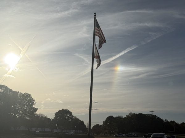
IMAGE OF THE DAY
Skywatcher Vanessa Sanchez captured a sundog over Hillcrest High School Yesterday afternoon!