


Daily Weather Briefing
Sunday, May 17, 2026

ALABAMA THIS MORNING
This morning is mild, with temperatures sitting in the mid 60s to upper 70s already. Earlier this morning, some patchy fog developed across Alabama, but nothing dense enough to warrant an advisory. Some high clouds stretch over south Alabama, but much of the state’s sky is clear. Skywatcher Daniel Harbin took this photo with a drone of the sunrise over Trenton this morning. In the distance, low-level fog fights to stick around against the morning light.
ALABAMA 7 DAY FORECAST
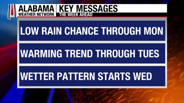
The beginning of this week features a low chance of showers and thunderstorms across much of the state, as well as a medium chance for multiple locations in Alabama to hit the low 90s. Then the rain chances increase toward the end of the week, especially for the northern half of the state, as a cold front pushes through north Alabama and stalls over north-central Alabama through the weekend.
POSSIBLE EASTERN SHOWERS TODAY
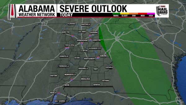
Showers and thunderstorms will affect Georgia and Florida today, and a few storms could stretch across the state line, bringing showers and thunderstorms to east Alabama. The chance of this happening is only 10%, but not zero. The Storm Prediction Center has highlighted the north and central portions of the Alabama-Georgia border to be under a Marginal Risk (1/5) of Severe Thunderstorms. Damaging winds and the possibility of hail will be the main concerns if storms develop.
The rest of the state will be dry and mostly clear. Highs will reach into the upper 80s and lower 90s, with the higher chance of 90s residing in the north.
SOME FOG TOMORROW MORNING
Tonight, conditions will dry out in the east, then skies will be mostly clear to partly cloudy. The lows will fall to the mild low to mid 60s statewide, which is close to the dew point, causing patchy fog to develop across Alabama.
SCATTERED SHOWERS POSSIBLE MONDAY
Tomorrow features another low chance of showers and thunderstorms, although there is no severe chance of storms. They will be pop-up, scattered thunderstorms, and the entire state has a 20% chance of them. Highs will be partly to mostly cloudy, and highs will climb to the upper 80s and lower 90s.
DRYING TUESDAY
Tuesday will be dry with partly cloudy skies. Highs will manage to reach the upper 80s and lower 90s one more day.
WET PATTERN TAKES HOLD WEDNESDAY THROUGH SATURDAY
A cold front pushes into north Alabama Wednesday, then stalls over north-central Alabama. This will bring medium to high shower and thunderstorm chances to the northern half of the state through Saturday. Since the front stays to the north, the southern half of the state will see a low chance of showers and thunderstorms through Thursday, then medium chances are expected Friday and Saturday.
Highs Wednesday will top out in the mid to upper 80s north and the upper 80s and lower 90s centrally and in the south.
On Thursday, highs will top out in the lower 80s north, the mid to upper 80s in central Alabama, and the upper 80s and lower 90s in the south.
A spread of low to upper 80s is expected across the northern half of the state on Friday, while the southern half of the state sees highs in the upper 80s and lower 90s again.
Highs will be limited to the low to mid 80s statewide on Saturday.
CONTINUED NICE WEATHER ON SHORE
The stretch of nice weather continues today, and there will be no better way to spend your Sunday than on our beautiful coast. The high will reach 81 degrees, skies will be mostly sunny, and winds will be from the southeast at 5 to 10 mph. Since skies are so clear, another day of a Very High UV Index is in store. The water remains calm, with a Low rip current risk and a surf height of around 1 foot. We remain rain-free until Thursday, when a low 10% chance of showers enters the forecast.

WEATHERBRAINS 1061 – SPACEY STUFF
Tomorrow’s WeatherBrains episode features space weather experts Rob Steenburgh and Shawn Dahl. Additionally, team member Tony Rice will bring another voice to the space weather conversation. Listen to the episode wherever you get your podcasts, or watch here.
TODAY IN WEATHER HISTORY
May 17, 1944 – Weather Decides D-Day
A pivotal decision in world history was set in motion as Dwight D. Eisenhower finalized plans on May 17, 1944, for the Allied invasion of Nazi-occupied France, targeting early June for what would become one of the most significant military operations ever undertaken. While strategy, logistics, and troop movements were critical, one of the most decisive factors in the operation was the weather. The invasion required a precise combination of environmental conditions—favorable tides to expose beach obstacles, adequate moonlight for airborne operations, and manageable seas for landing craft crossing the English Channel. In the weeks leading up to the operation, April and May 1944 brought relatively calm and favorable weather, reinforcing expectations that early June would offer suitable conditions. However, June 1944 defied climatology. A series of powerful low-pressure systems brought unusually stormy weather across the English Channel, producing rough seas, strong winds, and low cloud ceilings. These conditions posed serious risks to the invasion fleet and airborne divisions, threatening the success of the operation. A team of Allied meteorologists analyzed limited observational data from the North Atlantic, identifying a narrow break in the storm pattern. Their forecast indicated a brief lull in the severe weather beginning on June 6, following deteriorating conditions on June 5. Acting on this guidance, Eisenhower made the critical decision to delay the invasion by 24 hours. The Germans, relying on their own forecasts, believed the stormy pattern would persist and did not expect an invasion during such unfavorable conditions. This miscalculation contributed to the element of surprise when Allied forces launched the invasion during the temporary break in the weather. The decision, heavily influenced by meteorological insight, proved to be one of the most consequential weather-dependent calls in history. The successful landings on June 6, 1944—known as D-Day—marked the beginning of the liberation of Western Europe.
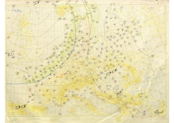

IMAGE OF THE DAY
Skywatcher Ron Lipham sent in a photo from his friend Daniel Foley. The picture captures last night’s vibrant sunset over Dog River in Mobile County.



