


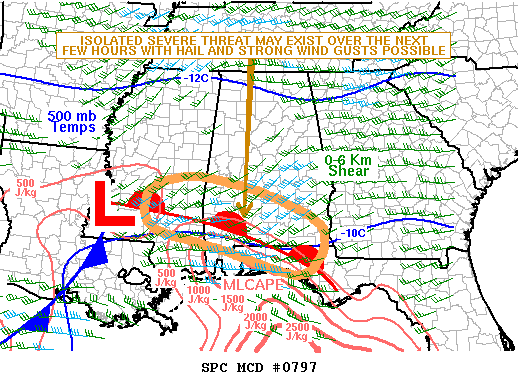
The SPC reports that storms along the warm front over South Alabama may be severe over the next few hours, but they do not expect to have to issue a watch.
This warm front will move north overnight and Sunday morning, probably making it a line from Jasper to Birmingham to Alex City by late on Sunday.
Rain and thunderstorms will continue to increase overnight and will be numerous tomorrow. North of the front, the storm will be elevated, meaning their bases will be higher off the ground than normal surface based storms. It makes them less likely to produce severe weather, but can make for some great rolling thunder as the lightning can come from higher up in the atmosphere making for a long superheated channel from which the crack of the thunder emanates.
MESOSCALE DISCUSSION 0797
NWS STORM PREDICTION CENTER NORMAN OK
0516 PM CDT SAT MAY 12 2012
AREAS AFFECTED…SRN MS…SRN AL…FL PANHANDLE
CONCERNING…SEVERE POTENTIAL…WATCH UNLIKELY
VALID 122216Z – 122345Z
PROBABILITY OF WATCH ISSUANCE…20 PERCENT
SUMMARY…AN ISOLATED SEVERE THREAT WILL LIKELY CONTINUE FROM SCNTRL
MS EWD ACROSS SRN AL FROM LATE THIS AFTERNOON INTO EARLY THIS
EVENING. HOWEVER…THE THREAT IS EXPECTED TO REMAIN MARGINAL AND WW
ISSUANCE IS NOT ANTICIPATED.
DISCUSSION…THE LATEST SFC ANALYSIS SHOWS A LOW OVER FAR SW MS WITH
A WARM FRONT EXTENDING EWD ACROSS SCNTRL MS INTO SRN AL AND THE FL
PANHANDLE. NUMEROUS THUNDERSTORMS ARE ONGOING ALONG AND TO THE NORTH
OF THE WARM FRONT WHERE THE AIRMASS HAS BEEN WORKED OVER.
MESOANALYSIS SUGGESTS THE STRONGEST INSTABILITY IS LOCATED FROM THE
WARM FRONT SWD WHERE MLCAPE VALUES ARE ESTIMATED FROM 1000 TO 1500
J/KG. IN ADDITION TO THE INSTABILITY…REGIONAL WSR-88D VWPS SHOW 40
TO 50 KT OF DEEP LAYER SHEAR SUGGESTING THE STORMS MAY BE ABLE TO
ROTATE AND APPROACH SEVERE LEVELS. THE SEVERE THREAT MAY BE GREATEST
FROM AROUND HATTIESBURG MS EWD INTO SRN AL ALONG AND JUST NORTH OF
THE FRONT. A WIND DAMAGE AND HAIL THREAT MAY EXIST WITH THE STRONGER
CELLS. HOWEVER…THE STORMS SHOULD BE INCREASINGLY ELEVATED NORTH OF
THE WARM FRONT WITH THE SEVERE THREAT DROPPING OFF QUICKLY WITH NWD
EXTENT.
..BROYLES.. 05/12/2012



