


The new balloon data is in from NWS Calera this evening. As we’ve been saying since about 1 pm, the models blew this system, and we’re going mainly off observations and physics tonight.
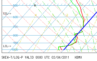
The red line is the temperature profile, and the green is dewpoint. The heavy blue line is the freezing line. There is a fairly deep layer of air above freezing between 950 mb (1,500 ft.) and 800 mb (7,000 ft. or so). That is why most of the precipitation has fallen as freezing rain, and continues to do so.
As the warmer raindrops fall, they freeze on contact, producing icing. However, as the warm raindrops keep falling tonight, temperatures are slowly rising. It is still 32 or lower in most of north and central Alabama at 8 pm, but it should rise to 33 or 34 by morning. There will still be some icy spots, especially on bridges and at higher elevations, tomorrow morning, as we have a pretty thick glaze of ice right now (almost 1/4″ in parts of BHM). That ice won’t all just melt in one hour even when it gets to 33. So, you might want to go into work late tomorrow, and use extra caution when driving.
Any travel tonight is discouraged.



