


Daily Weather Briefing
Saturday, October 24, 2026
ALABAMA THIS MORNING
Our Saturday morning starts chilly, with temperatures spanning from the low 40s to mid 50s. Skies are clear, and the sun is starting to rise, casting bright orange hues on the horizon seen on multiple of our Regions Skycams.
ALABAMA 7 DAY FORECAST
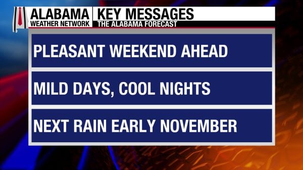
An upper-level ridge to our west and surface high pressure to the northeast will keep Alabama dry and slightly cooler this weekend. As we head into the week, the ridge will spread further into the state, warming us some and keeping rain chances at bay.
NICE FALL WEEKEND – Oct 24-25
The surface high pressure to the northeast will cause winds to be from the east today and tomorrow, bringing cooler air from the region into Alabama.
Today highs will rise into the low to mid 70s across the state with clear skies and winds around 5-10 mph in the northern half of the state and 5-20 mph in the southern half of the state. In this region, the southwest will see the lower end of this range, while the higher values will favor the southeast.
Sunday’s lows will be in the upper 40s to low 50s statewide, then highs will rise to the low to mid 70s again. Clear skies will persist, and winds will be at 5-10 mph everywhere but in the southeast, where winds will elevate to the 15-20 mph range again.
STILL DRY TO START THE WEEK – Oct 26-28
Monday through Wednesday will be similar to this weekend, but highs will begin to increase each day.
The mid 40s to low 50s start the week off on Monday morning, but the afternoon will see highs in the mid 70s across Alabama. Skies might not be so crystal clear, and winds calm down to 5-10 mph statewide.
The mid 40s to low 50s return Tuesday morning. The mid to upper 70s will spread over the state by the afternoon.
Highs in the mid to upper 70s are expected on Wednesday.
DRY AND WARMING TO END THE WEEK – Oct 29-30
Thursday and Friday will see dry conditions persist and highs continue to warm.
Thursday’s highs will be in the mid 70s to around 80 degrees, with the 80-degree temperatures favoring the west.
Highs on Friday will range from the upper 70s to around 80 degrees statewide.
RAINFALL OUTLOOK
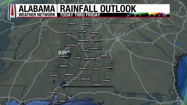
Alabama will be dry throughout the week this week, but there is a small chance a shower could produce less than a tenth of an inch of rain in the south.
LITTLE CHANGE TO DROUGHT CONDITIONS
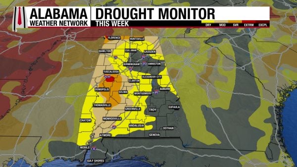
The drought conditions in Alabama have changed little from last week, with the only notable change in regard to the Severe and Extreme Drought in the state. The Severe Drought (D2) now covers 8.71% versus 8.10% last week. The Extreme Drought Conditions (D3) cover 0.81% of the state, while it was 0.75% last week. Our expected dry week this week will only exacerbate these conditions.
RACE WEEKEND IN TALLADEGA
The weather could not be better for race weekend at Talladega. Sunny, comfortable afternoons and clear, cool nights. Afternoon highs will be in the mid to upper 70s and morning lows in the upper 40s and low 50s.
FOOTBALL FORECAST
AUBURN VS. LSU
Auburn hosts LSU today at Jordan-Hare Stadium at 11:00 a.m. CDT. The Sky will be sunny, with temperatures rising from around 72 degrees at kickoff to around 76 degrees by the final whistle.
ALABAMA VS. TEXAS A&M
Alabama faces off against Texas A&M in Bryant-Denny Stadium at 2:30 p.m. CDT today. A sunny sky will preside over Tuscaloosa with temperatures in the mid 70s for the first half, falling into the upper 60s by the end of the game.
OTHER HOME GAMES
The weather looks great for all the other home games in Alabama today and tonight. Afternoon highs will be in the 70s, with temperatures falling into the 60s and 50s after sunset.
THE ATLANTIC
There is no tropical activity in the Atlantic.
THE PACIFIC
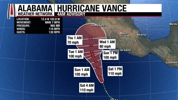
Category 2 Hurricane Vance has sustained winds of 110 mph and a central pressure of 965 mb. It is expected to stay at this strength as it moves north/northwestward this weekend and into next week.
BREEZY BEACH DAYS AHEAD
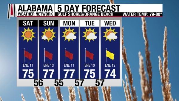
Winds of 10 to 15 mph from the northeast are expected on the coast over the next few days. These breezy conditions will keep the rip current risk High and the surf height around 2 to 3 feet. Besides the windy conditions, the weekend and next week look beautiful. The high will be in the mid 70s, the sky will be sunny, and the UV Index will be High.
TODAY IN WEATHER HISTORY
October 24, 2005 – Wilma’s Florida Landfall
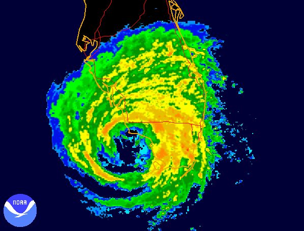
On October 24, 2005, Hurricane Wilma roared ashore along Florida’s southwestern coast near Cape Romano, just south of Marco Island, bringing sustained winds of approximately 120 mph as a powerful Category 3 hurricane. The storm had already carved a path of destruction across Mexico’s Yucatán Peninsula, where it lingered for nearly two days before emerging into the Gulf of Mexico. But instead of weakening further, Wilma regained strength over the warm Gulf waters and accelerated northeastward toward Florida. A powerful upper-level weather system sweeping across the United States helped propel the hurricane forward, and by approximately 6:30 a.m. EDT, its center was crossing the southwest Florida coastline. Unlike the slow-moving disaster in Mexico, Wilma raced across South Florida in less than five hours, carrying destructive hurricane-force winds from the Gulf Coast to the Atlantic Ocean.
The destruction began around Naples, Marco Island, and Everglades City, where powerful winds uprooted trees, damaged homes, and tore apart roofs and waterfront structures. At Naples, a wind gust reached 121 mph, while the hurricane’s enormous circulation spread damaging winds across much of southern Florida. As Wilma crossed the peninsula, its broad northern eyewall swept through densely populated Broward and Palm Beach Counties, producing particularly severe damage in Fort Lauderdale, Pompano Beach, Deerfield Beach, and Boca Raton. High-rise office buildings and condominiums lost thousands of windows, sending glass and debris into streets below. Roofs were peeled from homes, traffic signals collapsed, and enormous trees fell across roads and power lines. The hurricane retained surprising strength during its journey across land, emerging into the Atlantic near Jupiter as a Category 2 storm with winds still approaching 110 mph.
Although the center of Wilma passed north of the Florida Keys, the island chain experienced some of its worst coastal flooding in decades. Strong southwest winds drove Gulf waters across low-lying communities, producing the highest storm surge in the Keys since Hurricane Betsy in 1965. In Key West, water rose approximately six feet above sea level in some areas, flooding streets, businesses, and thousands of homes. North Roosevelt Boulevard disappeared beneath floodwaters, and vehicles were submerged throughout the island. Many residents had chosen to remain despite evacuation recommendations, expecting the worst of the hurricane to pass well to their north. Instead, the storm’s enormous wind field pushed water into neighborhoods that had escaped major flooding during other hurricanes. Damage extended across the Lower Keys, where boats were displaced, homes were inundated, and electrical service failed across entire communities.
The consequences across South Florida were staggering. Approximately 2.6 million utility customers lost electricity, affecting an estimated six million people and producing one of the largest power failures in Florida history. In some communities, electricity remained unavailable for weeks as utility crews confronted thousands of broken poles, fallen transmission lines, and damaged substations. Schools closed, businesses remained shuttered, gasoline became difficult to obtain, and long lines formed at distribution centers providing food, water, and emergency supplies. The storm also damaged hospitals, airports, government buildings, and agricultural operations, including portions of Florida’s already battered citrus industry. At least several deaths in Florida were directly attributed to Wilma, with additional fatalities occurring during the aftermath and cleanup. The hurricane’s economic toll was immense, with the National Hurricane Center estimating approximately $20.6 billion in damage across the United States.
Hurricane Wilma became one of the defining disasters of the historic 2005 Atlantic hurricane season, a year already marked by Katrina, Rita, and Dennis. It was the last major hurricane to make landfall in the continental United States until Hurricane Harvey struck Texas nearly twelve years later in 2017. Wilma also held the distinction of being the most intense Atlantic hurricane on record, having reached an extraordinary central pressure of 882 millibars during its earlier passage through the Caribbean. Its Florida landfall demonstrated that even a rapidly moving hurricane could produce catastrophic consequences when its powerful wind field crossed heavily populated communities. For millions of Floridians, the memories of October 24, 2005, were not simply of howling winds and shattered windows, but of darkened neighborhoods, flooded homes, and the long struggle to restore daily life after one of the most damaging hurricanes in the state’s history.
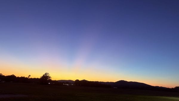
IMAGE OF THE DAY
Skywatcher Daniel Harbin captured the serene sunset in Gurley yesterday evening.



