


Daily Weather Briefing
Saturday, April 4, 2026
ALABAMA THIS MORNING
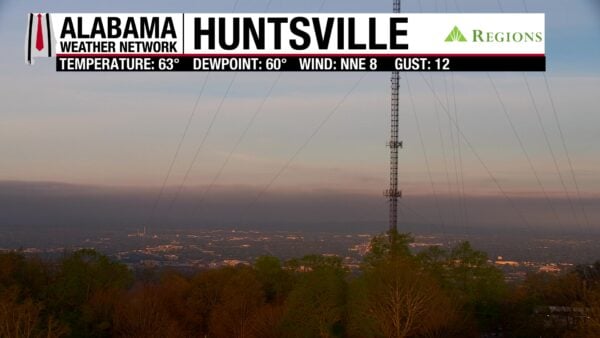
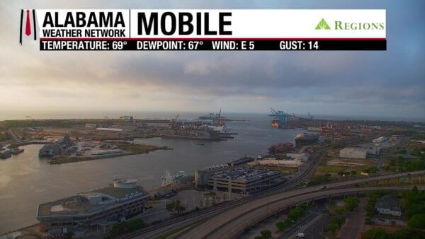
Alabamians wake to a quiet Saturday morning. Clouds cover parts of central and south Alabama this morning and elsewhere is clear. Winds range from calm to blowing at less than 10 mph. Temperatures range from the low to upper 60s across the state, in a quite sporadic pattern.
Our Huntsville and Mobile Regions Skycams capture the calm morning perfectly.
ALABAMA 7 DAY FORECAST
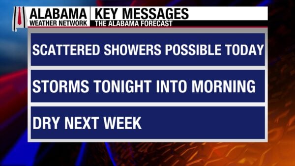
A few scattered showers and thunderstorms are possible today. A cold front will push through the state starting this evening, bringing with it a more organized line of thunderstorms. It will hit the south by tomorrow morning as a weaker line. The state will be dry by late tomorrow afternoon, and a cooler and drier airmass will be keep the next week pleasant. Cool and dry conditions persist, with a dry cold front traversing Alabama Tuesday. A slow warming trend takes place through Friday.
SCATTERED SHOWERS TODAY
There is a low chance of scattered showers in the northern half of the state today, and it increases some in the southern half. They will stay sub-severe. Clouds will be increasing throughout the day, and highs will be in the low to mid 80s statewide.
COLD FRONT PASSES TONIGHT
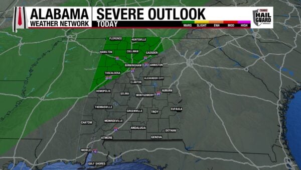
The cold front will enter the northwestern corner of the state around 4-6 p.m. CDT this evening. There is a Marginal Risk (1/5) of Severe Thunderstorms from Florence to the north of Demopolis, through Birmingham and Gadsden. The main concern with the line of thunderstorms will be hail and damaging winds of 60 mph. An isolated brief tornado cannot be ruled out. As the line pushes southeastward throughout the night, it will begin to lose its intensity, and south-central/south Alabama will wake to sub-severe thunderstorms. Lows will begin to fall in the north behind the front and will read around the low 50s. Central and south Alabama will range from the upper 50s to mid 60s.
WET EASTER MORNING
Although north and central Alabama will see the end of their rain in the early morning, wet ground may make Easter Egg hunts something done indoors Sunday morning. South-central and south Alabama should prepare for a wet and potentially stormy Easter morning and as well as indoor egg hunts. Showers will clear out in the southwest by early afternoon, while the southeast will see showers and thunderstorms through late afternoon/early evening. Highs will be much cooler than today’s, sitting in the upper 60s for the northern two-thirds of the state and the lower 70s in the south. A 70-degree mark may sneak into central Alabama. Geneva and surrounding areas may be stubborn and stay in the mid 70s. Clouds will decrease from north to south through the day, and the northern half will see sunny skies.
SPRING RETURNS MONDAY
Next week will be much drier and cooler than the past week’s warm and humid pattern. Monday morning will be cold, with lows in the low 40s north and upper 40s south. Prepare plants, pets, and pipes for the cooler temperatures. Sunny skies dominate Monday, but the coast has a chance for gloomy skies. Highs will warm to the upper 60s to lower 70s over Alabama.
DRY COLD FRONT TUESDAY
Another cold front will pass through the state Monday night into Tuesday. There will be very little temperature difference with the front, but winds will be breezy. Highs will range from the upper 60s and lower 70s north and the mid 70s centrally.
QUIET END TO THE WEEK
Wednesday through Friday will be quiet, with a warming trend expected. Highs Wednesday will stay in the lower 70s, with 70-degree readings anticipated in the east and 72-to-73-degree marks in the west.
Thursday will be dry and highs will increase to the mid 70s. Friday will be similar but a few locations will only hit the low 70s.
WORSENING DROUGHT
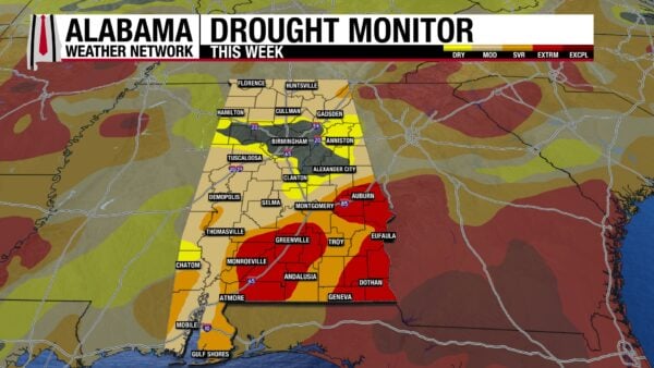
The main story with drought this week is the sharp increase in the area that the Extreme Drought (D3) category has seen. From only 5.32% of the state in Extreme Drought last week to 17.96% this week, drought conditions have certainly been exacerbated. These Extreme Drought areas are in south and southeast Alabama, areas that are expecting to see the least amount of rainfall accumulation with this weekend’s upcoming cold front. More of the state is in a Moderate Drought (D1) as well, with the category jumping from 40.65% to 44.18%. Next week’s dry conditions will only continue to worsen the state’s drought.
LAST DAY OF SUMMER PATTERN
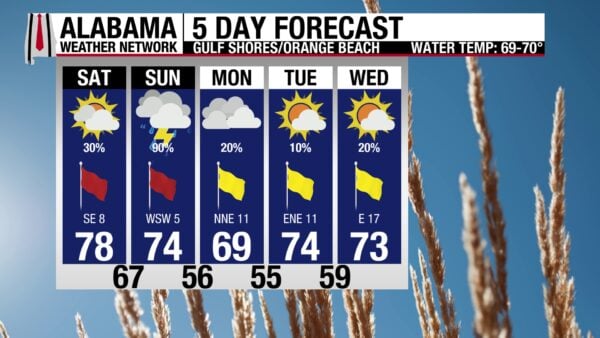
Today is the last day of the summer pattern of scattered thunderstorms in the afternoon. Before the showers, skies will be mostly sunny, allowing for a very high UV Index. Continued southeast winds at 10 mph is the cause of the high rip current risk and surf height of 3 to 4 feet. Tomorrow, especially in the morning, will be a wash out.
TODAY IN WEATHER HISTORY
April 4, 1977 – The Birmingham Tornado
On April 4, 1977, a catastrophic F5 tornado struck northern Birmingham, Alabama, moving northeast at approximately 60 mph for nearly 15 miles through Jefferson County. The tornado formed about four miles northwest of downtown Birmingham near U.S. Highway 78 and grew to a maximum width of around three-quarters of a mile (approximately 1,320 yards), leveling everything in its path. Its strongest impact occurred in the Smithfield Estates subdivision, where 167 homes were destroyed and another 48 sustained major damage. Daniel Payne College suffered severe structural damage, and the tornado tossed cars and trucks into the air as it crossed busy Interstate 65. The storm caused 22 fatalities and injured roughly 130 people, making it one of the deadliest tornadoes in Alabama history. Damage was reported to homes, businesses, and public infrastructure along the path, and the tornado completely uprooted trees and power lines. This event was part of a larger outbreak that produced additional tornadoes that day, which killed one person elsewhere in Alabama and another in Georgia.
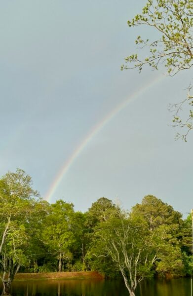
IMAGE OF THE DAY
Skywatcher James Micetich sent in a picture of the beautiful rainbow in Fadette after its evening rains.



