


Daily Briefing
Sunday, November 23, 2025
ALABAMA THIS MORNING
Alabama wakes up this Sunday to mild, quiet weather behind yesterday’s weak front, with temperatures starting out in the upper 40s and 50s and skies gradually clearing from north to south. Most of the state is dry this morning, and any patchy fog that formed overnight is lifting quickly with the early daylight. A dense fog advisory is in effect until mid-morning for southeastern Alabama. Sunshine will take over through the morning hours, setting the stage for a pleasant, seasonably warm day before clouds begin to thicken again late tonight ahead of the next rainmaker.

Daniel Harbin sent in this beautiful sunrise picture on Sunday morning. Everyone was pretty much in the 50s, except for Vic Bell and Jake Argo, who were in the 40s in Black Creek and Argo, respectively.
Join the team! Learn how to become a Spann Skywatcher: https://www.spannskywatchers.com/
ALABAMA FORECAST
Alabama starts this Sunday on a quiet and pleasantly mild note, with clearing skies, light north winds, and early temperatures ranging from the upper 40s in the north to the mid 50s farther south. Yesterday’s weak front has moved offshore, and the lingering clouds and patchy fog are fading quickly this morning. Sunshine will dominate for most of the day, giving the state a calm and comfortable finish to the weekend.
The dry, stable pattern holds through tonight and into Monday as shortwave ridging slides overhead. Highs today and Monday will run in the low to mid 70s for most of the state, with upper 70s possible in the Wiregrass and along the Gulf Coast. Overnight lows remain seasonably cool—generally in the 40s north and 50s south—with no major fog issues expected.
Attention then turns to a developing upper low lifting out of the Baja region, which sends a stronger system toward the Lower Mississippi Valley. Clouds will thicken across Alabama on Monday, and showers and thunderstorms become likely Monday night into Tuesday statewide. The risk for severe storms remains low, thanks to limited instability and weaker lapse rates, but a few stronger storms cannot be completely ruled out—especially west of I-65 where moisture returns first. The bigger guarantee is much-needed rain, with widespread totals expected Tuesday into early Wednesday.
A cold front moves through on Wednesday, gradually ending the rain from northwest to southeast. Behind it, cooler and drier air takes over. Thanksgiving Day looks crisp and seasonable statewide, with highs in the 50s and lows in the upper 20s to low 30s by Friday morning. The holiday weekend stays dry, quiet, and cool under high pressure.
ALABAMA POSTS A NEW SET OF NOVEMBER HIGHS
Alabama wrapped up November 22nd with impressive warmth, as five major reporting sites tied or broke long-standing high-temperature records. Birmingham, Anniston, and Tuscaloosa all reached 81 degrees, each edging past records that had stood for decades, while Mobile matched its 1973 benchmark at 81. Dothan topped the state with a summerlike 85 degrees, surpassing its previous record of 82 set in 2011 — a fitting capstone to an unusually warm late-November afternoon.
NATIONAL NEWS…
TODAY’S PLAINS SYSTEM KICKS OFF A FLASH FLOOD RISK
A storm emerging out of the Southwest brings widespread showers and storms to the central and southern Plains today, with repeated downpours boosting the flash-flood threat from south-central Oklahoma into the Texas Hill Country. Recent heavy rain only adds to the concern as storms track roughly parallel to the front.
PACIFIC NORTHWEST GETS RAIN AND MOUNTAIN SNOW
A Pacific system spreads coastal rain and locally heavy mountain snow across Washington and Oregon today and into Sunday, eventually pushing into the northern Rockies. Lower elevations pick up steady rainfall while the higher terrain sees accumulating snow that becomes heavier overnight.
NEW ENGLAND TURNS SEASONAL AS THE NEXT FRONT ARRIVES
A frontal boundary sliding from the Great Lakes into the interior Northeast brings scattered rain and snow showers tonight into Sunday. Highs hold in the 30s and 40s across New England, offering one of the few truly seasonal pockets of air across the country as the rest of the East stays well above average.
ATLANTIC TAKES ANOTHER WEEK OFF
The tropics are completely quiet this morning, with nothing trying to organize from the Caribbean to the open Atlantic. The National Hurricane Center keeps the development chances at 0% for the next seven days, giving the basin a calm stretch as we move toward the end of the season.
BEACH WEATHER…
SUNNY SUNDAY SHINES ALONG THE COAST
A beautiful beach day is on tap for Sunday, with mostly sunny skies and highs in the mid 70s stretching from Dauphin Island to Destin and eastward toward the Forgotten Coast. Surf runs a gentle 1 to 2 feet with water temperatures in the lower 70s — perfect for wading or strolling along the shoreline. Rip current risks range from low along Alabama and the western Florida Panhandle to moderate across parts of the eastern Panhandle and Apalachicola, so swimmers should stay aware of posted flags. Looking ahead, a return to moderate and even high rip current risks begins Tuesday as winds strengthen ahead of the next cold front.
TODAY IN WEATHER HISTORY
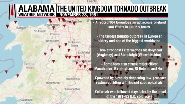
November 23, 1981 – UK Tornado Outbreak
On November 23, 1981, the United Kingdom experienced the largest tornado outbreak in European history as 104 tornadoes touched down across England and Wales in just five and a half hours. Most were rated F0 to F1, though two reached F2 intensity—one striking Holyhead on Anglesey and another hitting Stoneleigh in Warwickshire. Tornadoes also moved directly through major urban areas including Manchester, Birmingham, St Helens, and Hull, damaging homes, shops, trees, and outbuildings. The outbreak was fueled by a rapidly deepening low-pressure system off northern Scotland that collided with humid subtropical air drawn northward. Only eight people were injured, but the scale of the event remains one of the most extraordinary severe-weather episodes ever recorded in the U.K., occurring just days before the arrival of the historic 1981–82 cold wave.

IMAGE OF THE DAY
Spann Skywatcher Sandra Kirkwood snagged this photo of a beautiful cloud from her location near New Market in Madison County on Saturday afternoon. It made me want to go fly a kite! Thanks, Sandra!



