


Daily Weather Briefing
Friday, June 19, 2026
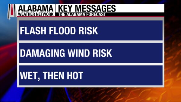
ALABAMA THIS MORNING
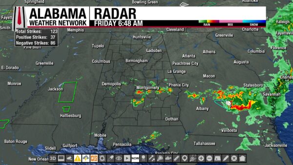
Most of Alabama enjoys a respite from the rain this morning with partly to mostly cloudy skies. However, light showers spread from Linden to Selma, and thunderstorms surround but do not impact (as of right now) Montgomery. These showers and thunderstorms stretch to the west of Hurtsboro. Temperatures sit in the low to mid 70s from north to south, while Atmore, Mobile, and Gulf Shores reach 78, 79, and 82 degrees respectively. It is yet another humid morning as well, as dewpoints are also in the low to mid 70s statewide and the upper 70s and lower 80s in the southwest.
ALABAMA 7 DAY FORECAST
North Alabama will be mostly dry today with rain chance increasing as you head south. This is due to a cold front that has entered the northwest that will move south throughout the day. The front will lift back to the north Saturday, keeping rain chances elevated south and limited north. Then a low-pressure system to our west will bring southerly flow and high moisture content back to the north Sunday, and the entire state will see showers and thunderstorms. Storms will be more common north on Monday due to more moisture from an area of low-pressure to the west. Then the low’s cold front will push through Alabama Tuesday and Wednesday, keeping rain chances elevated across the state. Afternoon scattered showers and thunderstorms return Thursday.
FRONTAL PASSAGE TODAY
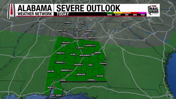
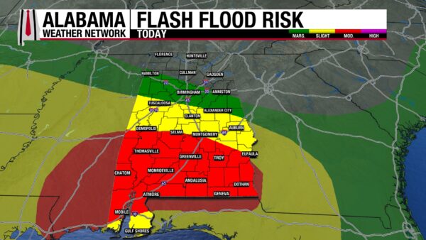
A cold front will move south throughout the day today. This will dry north Alabama, lessen rain coverage in central Alabama to isolated to scattered, and keep south Alabama entrenched in a short-wave upper-level trough. North and north-central Alabama sit under no severe weather threat and either no risk or a Marginal Risk (1/5) for Flash Flooding today. Highs will hit the mid to upper 80s. The rest of central and south Alabama will be wet again today. Scattered to widespread showers and thunderstorms have a Marginal Risk (1/5) for developing into strong to severe thunderstorms with damaging winds as the main threat. Additionally, the concern for Flash Flooding is Moderate (3/4) in south Alabama and Slight (2/4) in central Alabama as storms may train (redevelop) over the same area multiple times today. 1-3″ of rain is anticipated, but locally higher amounts are almost guaranteed. Highs will hit the mid 80s.
RAIN CONTINUES SOUTH, DRIER NORTH SATURDAY
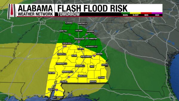
The northern half of the state will be even drier tomorrow as dry air and an upper-level ridge attempt to get settled behind the frontal passage. Skies should be partly to mostly cloudy and besides a few isolated showers, the state region will be quiet. If showers do form, the soaked ground will have little room to hold rainwater, so a Marginal Flash Flood Risk sits in this half of the state. The southern half of the state deals with another day of rain, and a Slight Risk (2/4) for Flash Flooding stretches across the region. No severe weather is expected, but some storms may be strong. Highs hit the mid 80s statewide.
SCATTERED WIDESPREAD SHOWERS SUNDAY
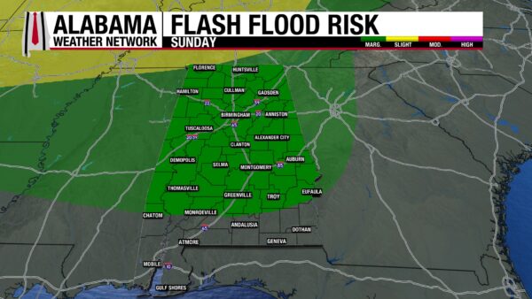
On Sunday, the entire state has a 60% chance of showers and thunderstorms as a low-pressure system brings moisture back to the north. A Marginal Risk of Flash Flooding extends into the south, but the southernmost portion of the state is not included in any flood outlook, which will come as quite a relief. Highs will range from the mid to upper 80s north to the upper 80s and lower 90s south.
STORMS NORTH MONDAY
The low-pressure system’s cold front will push thunderstorms out ahead of it, bringing widespread showers and thunderstorms to the northern half of the state. The southern half of the state will avoid the brunt of these storms, seeing only a 20% chance of thunderstorms Monday. Highs will begin to return to those hot summer temperatures, and the upper 80s are expected north, while the upper 80s and lower 90s spread across central and south Alabama. Feels-like temperatures around 100 degrees are possible in the south.
FRONTAL PASSAGE TUESDAY AND WEDNESDAY
The front from the low-pressure system will slowly make its way through the state Tuesday and Wednesday, bringing rain chances in the 30-40% range to Alabama. Highs will span from the low to mid 80s north, the upper 80s centrally, and the upper 80s and lower 90s south on both days.
AFTERNOON STORMS THURSDAY
The front may stall in south Alabama Thursday, and scattered afternoon showers and thunderstorms will keep that low-to-mid rain chance around in the state. Highs will climb back into the upper 80s and lower 90s.
RAINFALL OUTLOOK
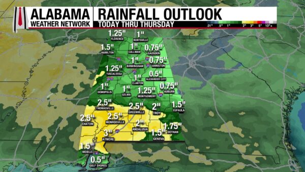
After an impressive amount of rain fell yesterday, especially in the south, the state can still expect another 1 to 3” of rain over the next week. The Excessive Rainfall Outlooks are included here as well. Flash flooding will be one of the main concerns this week as our ground is very saturated, and it will take less rain than usual to cause water levels to rise and runoff to occur.
NOT MUCH DROUGHT IMPROVEMENT
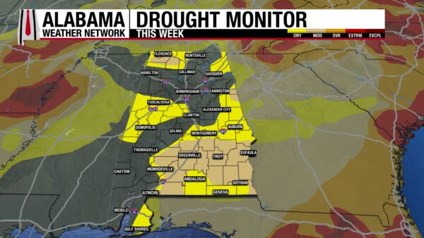
Despite quite a bit of rain across Alabama this week, the drought has improved little. The percentage of the state that is no longer in a drought has increased by 3% to about 48%. Otherwise, the Abnormally Dry and Moderate Drought areas in the state have seen a 1% decrease in coverage. Of course, we’re expecting this drought to be greatly impacted by yesterday’s rain, but we’ll have to wait until next Thursday to see its overall impact.
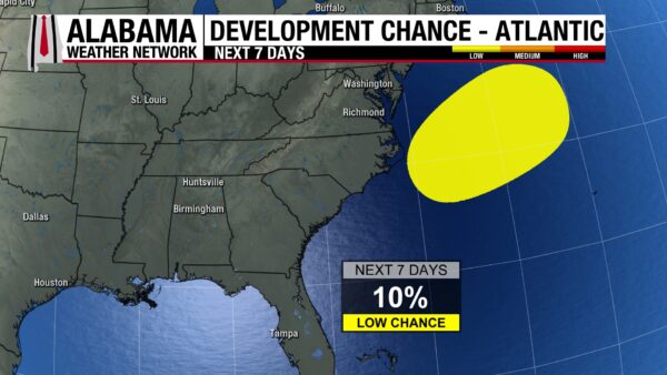
ARTHUR’S SECOND WIND?
The remnants of Tropical Storm Arthur are expected to emerge over the Atlantic Ocean this afternoon where it will meet conditions that are marginally conducive to tropical or subtropical development. We will be watching what’s left of Arthur to see if it has a second wind.
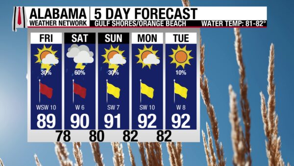
BETTER BEACH CONDITIONS TODAY
Despite a 30% chance of showers and thunderstorms today, skies will be mostly sunny, and the UV Index will be Very High. These sunny conditions will be much welcomed after a week of gloom on the coast. Additionally, the high will be in the upper 80s, and the winds from the southwest at 10 to 15 mph will be breezy but not too inconvenient. The waters have not calmed as much as the atmosphere has, and there is still a High rip current risk as well as a High Surf Advisory, as the surf height will reach 4 to 6 feet today. Enjoy the sand and the shore but continue to avoid the water. A higher rain chance and continued High rip current risk make for a less-than-ideal beach day tomorrow.

TODAY IN WEATHER HISTORY
June 19, 1938 – The Olympian Falls
Just after midnight on June 19, 1938, the westbound Olympian of the Chicago, Milwaukee, St. Paul and Pacific Railroad was rolling across eastern Montana. It was a proud transcontinental passenger train, bound from Chicago toward the Pacific Northwest, carrying sleeping passengers through the open country southwest of Terry, MT. Ahead of it was Custer Creek, a stream that was often dry or shallow for much of the year. On this night, after hours of intense thunderstorms and cloudburst rains, that little creek had become something entirely different.
The rainfall was extraordinary for the landscape. Estimates generally range from about four to seven inches over the drainage area, enough to send water racing down clay hillsides toward the Yellowstone River. Earlier in the evening, the bridge had not shown obvious signs of imminent failure, and another train had crossed safely. The water rose rapidly, scouring around the bridge supports and carrying debris, mud, and violent current toward the rail line in the darkness.
At about 12:35 a.m., the Olympian reached the bridge at high speed. There was no sheet of water across the rails to warn the engineer that the structure beneath the train had been undermined. As the locomotive and cars moved onto the span, the weakened bridge failed. The engine and several cars plunged into the flood-swollen creek and crashed into the far bank and the torrent below. One sleeper car was submerged, trapping passengers in the darkness as water poured through the wreckage.
The scene was chaotic and heartbreaking. Survivors, railroad crew members, and rescuers worked in mud, wreckage, and swift water, breaking windows and trying to reach people in the partially submerged cars. In commonly cited modern accounts, 49 passengers and crew were killed and about 75 were injured, making the Custer Creek wreck Montana’s deadliest railroad disaster. Some victims were carried into the Yellowstone River, and at least one body was later found 130 miles downstream near Sidney, MT.
The official investigation found that the volume and velocity of water that night were far beyond what had been experienced or reasonably anticipated at that location. The bridge had appeared serviceable, but the cloudburst had changed the creek faster than human observation could keep up. Custer Creek became a tragedy of timing, terrain, and hidden flood force. A train that had crossed the plains in confidence met a bridge that looked passable from above, while underneath, the water had already decided the outcome.
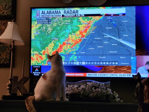
IMAGE OF THE DAY
Skywatcher Sandra Kirkwood’s cats love to watch The Alabama Weather Network. Here is OMG (Olen Maki Gatlin) watching this morning’s early live coverage!



