RADAR CHECK: Several large areas of light rain are moving across North and East Alabama early this morning; the southwest part of the state is dry. By afternoon most of the rain will be over with just a few spotty showers over the southern counties of the state; temperatures reach the 60s this afternoon.

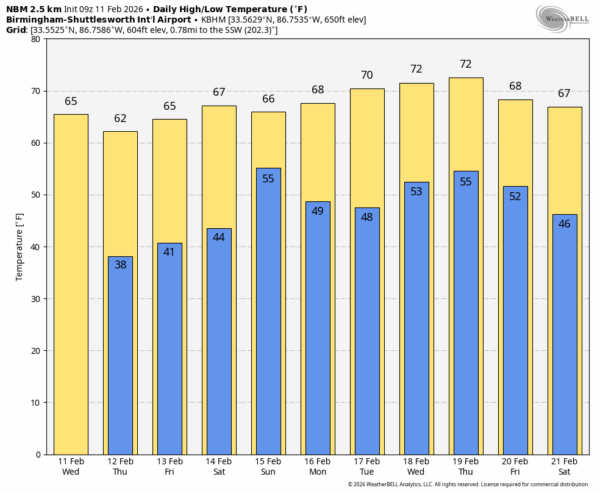
Tonight will be colder; temperatures drop into the 30s over the northern half of Alabama, with 40s to the south. The weather will be dry tomorrow and Friday with highs mostly in the 60s.
WET WEEKEND: An upper trough/surface low will bring rain into the Deep South this weekend. A decent part of the day Saturday will be dry, although showers are certainly possible. The most widespread rain will come Saturday night and Sunday; rain amounts of 1-2 inches are likely statewide… parts of South Alabama could see over two inches.
A rumble of thunder is possible over the southern third of the state, but there will be very little surface based instability available, and for now we are not expecting severe thunderstorms.
NEXT WEEK: Monday and Tuesday will be dry and mild with highs in the 65-75 degree range. Most all of Alabama will see highs at or over 70 degrees over the latter half of the week. Global models suggest a few spotty showers will be possible Wednesday/Thursday, but nothing really heavy or widespread. See the video briefing for maps, graphics, and more details.
ON THIS DATE IN 1965: An F3 tornado moved through parts of Pickens County. Twelve homes were demolished and another 42 homes suffered varying degrees of damage. A church, motel, cotton mill, and several commercial buildings were heavily damaged. One farm suffered extensive damage. Several injuries occurred in and near Aliceville, but no fatalities were reported.
Look for the next video briefing here by 3:00 this afternoon… enjoy the day!