


Daily Weather Briefing
Tuesday, June 16, 2026
ALABAMA THIS MORNING
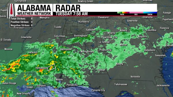
It’s a wet and rainy morning for most of Alabama and showers stretch from as south as the coast to as north as Gadsden. North Alabama is dry for the most part, and mostly cloudy. Temperatures sit in the upper 60s north and the lower 70s in central and south Alabama. The Alabama-Florida state line is a little warmer in the mid 70s, and Gulf Shores is already at 81 degrees.
ALABAMA 7 DAY FORECAST
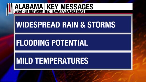
Our active weather pattern continues today, with widespread and heavy rainfall falling across central and south Alabama today, accompanied by a low-end severe weather threat for the south. Tomorrow should see less coverage of rainfall wise as it is limited to the south, then Thursday gets interesting. A tropical system (regardless of strength or status) will move across the Southeast, bringing more heavy rainfall and a low-end severe weather threat for the entire state. Rain will not back off Friday as a cold front traverses through Alabama. We are in for multiple days of thunder, wind, rain, and flooding. A brief break from the rain is possible Saturday, then increase again Sunday onwards in the north but stay on a declining trend in the south.
RAIN AND STORMS FOR CENTRAL AND SOUTH ALABAMA TODAY
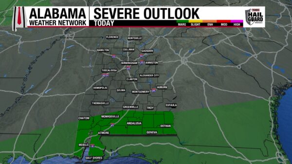
It’ll be a wet and rainy day across central and south Alabama today. With their position being south of a stalled frontal boundary within an upper-level trough, moisture will be more than available, and showers and thunderstorms will be widespread across the region. Rainfall will be heavy, and with south Alabama already quite wet from their rain yesterday, flash flooding is possible. Additionally, there is a Marginal Risk (1/5) of Severe Thunderstorms over south Alabama today. Damaging winds, hail potential, and a possibility of a brief spin up tornado is what we’re watching with these storms, with severe chances higher toward the afternoon and evening. Highs across central and south Alabama will be limited to the mid to upper 70s by the cloud cover and rain. A few spots in south and coastal Alabama will be able to reach the lower 80s.
North Alabama will be mostly dry, with any showers staying south of the Tennessee River. The rain chance in this region is only 20-40%, so the flash flood threat is almost zero, especially since the north has been drier than its more southern counterparts. Skies will be partly to mostly cloudy, so the sunshine will be able to peak through, and highs will hit the upper 70s and low to mid 80s.
LIGHT SHOWERS TONIGHT
Some light showers may stick around toward eastern north-central tonight, but otherwise, it’ll be dry and cloudy over the state. Lows will hit the mid 60s north, and the upper 60s and lower 70s centrally and in the south.
SHOWER COVERAGE SHRINKS WEDNESDAY
Luckily on Wednesday, the weather settles somewhat, and the rain coverage becomes less widespread. Scattered showers and thunderstorms will favor central and south Alabama, while the north might see just a quick shower or two. The scattered instead of broad pattern provides some relief to what will be a water-logged south Alabama (although it will still be a wet day). Highs will climb into the mid to upper 80s north, with a possible 90 degree reading in the northwest. Central and south Alabama will hit the mid 80s.
DOWNPOURS AND STORMS THURSDAY
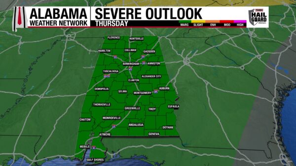
The entire state will be wet on Thursday as the area of low-pressure, we’ve been watching in the Gulf/over Mexico will make its way through our state. It is yet to be determined if it becomes a named storm or not (more in the Tropical Update section below). Regardless, it will drop an excessive amount of rain over Alabama as it pushes through, and a Moderate Risk (3/4) for Excessive Rainfall stretched across south-central Alabama. More in the Rainfall Outlook below. It will also bring an unsettled atmosphere, and there is a Marginal Risk (1/5) of Severe Thunderstorms across the entirety of Alabama Thursday. Strong winds and the possibility of a tornado are what we’re watching with the storms. Highs will hit the mid 80s statewide, with a few isolated locations reaching the upper 80s and even 90 degrees.
FRONTAL PASSAGE FRIDAY
After the low pushed through Alabama Thursday, a cold front from a low-pressure system in the northeast will move through our state Friday. More widespread rainfall is expected throughout the day, but no severe weather is expected right now. Highs will range from the low 80s north to the mid 80s south, and the upper 80s and 90 degrees on coast.
QUIETER SATURDAY
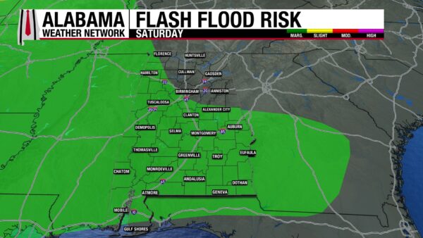
Saturday will bring a much-needed break from the rain as isolated to scattered showers are expected. Rain chances stay more elevated south than in the north as the front lingers south of Alabama, keeping moisture availability elevated. Across the state, highs will rise to the mid 80s.
RAIN CHANCES DIVULGE NEXT WEEK
In the northern half of the state, rainfall chances begin to increase again Sunday and Monday as another upper-level disturbance moves in from Mississippi. Meanwhile, chances decrease slowly in the south. Highs rise easily into the upper 80s over Alabama Sunday. Heat returns Monday, with highs spanning from the upper 80s north, and the upper 80s and lower 90s south.
RAINFALL OUTLOOK
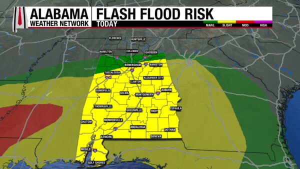
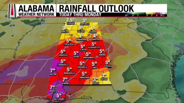
Today, a Slight Risk (2/4) for Excessive Rainfall Spreads from south Alabama to central Alabama. A Marginal Risk (1/4) extends to jus south of Hamilton, Cullman, and Gadsden. Anywhere from a quarter of an inch in the northern extent of this risk to 2” in the southern extent could fall today. Flash flooding is a concern.
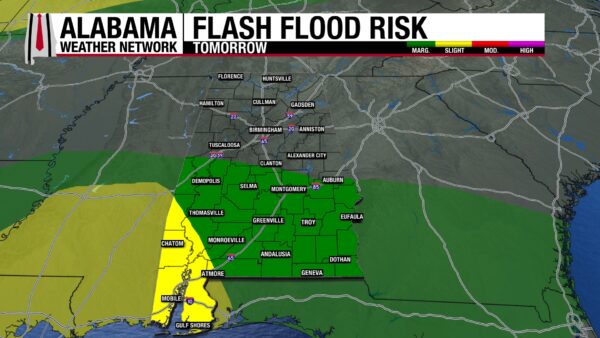
Tomorrow, the risk dwindles and shrinks, falling to a Marginal Risk across south Alabama, while the southwest remains in the Slight Risk. A quarter of an inch to three quarters of an inch could fall in this region. Although that does not sound like a lot of rain, this region has already seen up to 1-2″ of rain in the past 24 hours. Combine that with the rain we’ll see today, the ground will be soaked and will have little space for even more water.
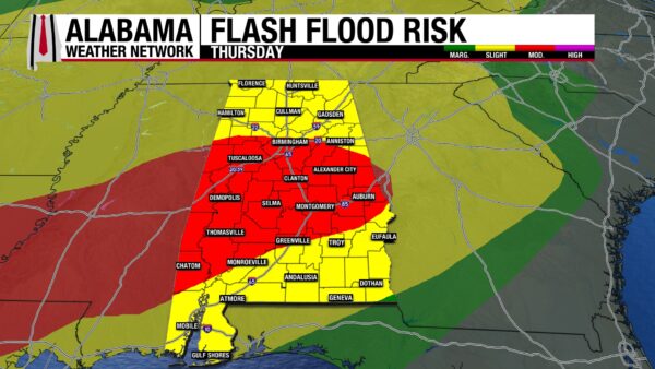
Thursday is the truly concerning day, as a Moderate Risk (3/4) for Excessive Rainfall (Flash Flooding) has been placed across central ad south-central Alabama, preparing for the low-pressure system that will move across the state. A Slight Risk is in place across the rest of the state. Up to 3”, maybe even 4 in southwest could fall Thursday. This is a large amount of rain to fall on top of the rain that will have already fallen.
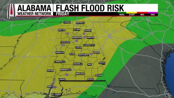
Friday sees a Slight Risk that stretches across Alabama, as the front brings up to an inch and a half to 2” to the state.
The risk finally falls to Marginal for northwest, central, and south Alabama as a drier pattern comes to our rescue. Despite it being drier, any rain that falls (0.25” to 1.5”) will pile onto the impressive amount of rain we will see this week, and it will take little for flash flooding to occur.
In all, 2.5” to 7” of rain will fall in Alabama over the next seven days. Flash flooding is possible and almost guaranteed. Make sure to be extra careful on the roads this week, and remember to Turn Around, Don’t Drown! If you have any outdoor interests or furniture, consider bringing them inside.
THE GULF GETS ACTIVE, A NEW PACIFIC DISTURBANCE
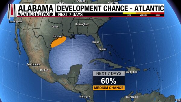
The area of interest we’ve been watching over the past several days has been upgraded to having a 60% chance of development over the next 2 and 7 days. Residing over the Texas/Mexico border right now, it is expected to emerge over the northwestern Gulf today, where conditions are somewhat conducive for the development into a short-lived tropical cyclone. If it does develop into anything, it will be tomorrow. It is expected to move across Louisiana and Mississippi first, then impact us Thursday. Regardless of development, strong winds, low-end severe weather, and lots of rain are anticipated on the Gulf Coast.
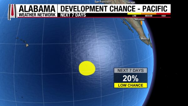
Meanwhile in the Pacific, an area of interest with a low chance, 20%, of development has formed well southeast of Hawaii, but it is expected to run into some dry mid-level air soon.
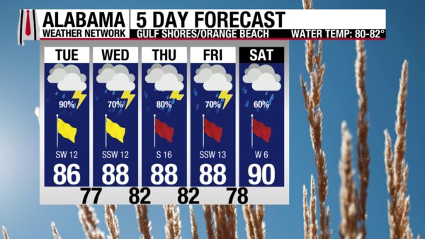
STORMY WEEK ON THE BEACH AHEAD
Unfortunately, there are multiple days of high rain chances expected on the coast this week. Today alone, a 90% chance of showers and thunderstorms is in the forecast. The high will be in the mid 80s, skies will be cloudy, and winds will be from the southwest at 15 mph. They will contribute to a Moderate risk of rip currents today, so if you do decide to get in the water, make sure there is no lightning in the area and that you are extra careful of rip currents. As the tropical system moves closer to the state this week, the rip current risk will increase, and storm chances will stay elevated. Time to find some entertaining indoor activities!
Coastal flooding will be an issue as well as Mobile is expecting up to 7” of rain in the next 7 days.
TODAY IN WEATHER HISTORY
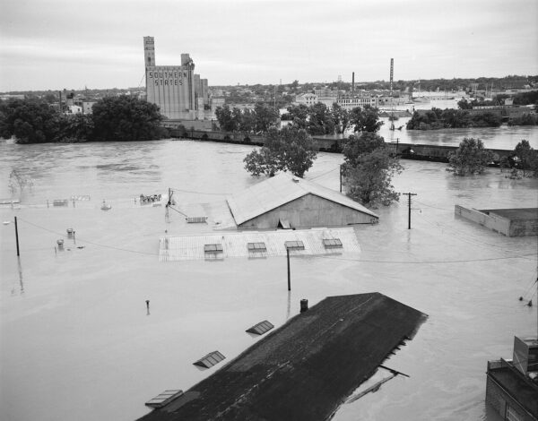
June 16, 1972 – Agnes Reborn
Agnes was born on June 16, 1972, as a tropical storm east of the Yucatan Peninsula, then moved north into the Gulf of Mexico and briefly strengthened into a hurricane. It made landfall near Cape San Blas on the Florida Panhandle on June 19 as a minimal hurricane, bringing coastal impacts and heavy rain. But Agnes would be remembered less for its winds than for what happened after landfall, when the storm weakened, drifted inland, and carried a deep reservoir of tropical moisture into the eastern United States.
After moving through the Southeast, the remnants of Agnes encountered a larger weather pattern along the Mid-Atlantic coast. An upper-level trough helped a new surface low develop near Virginia, allowing the old tropical circulation to reorganize and regain tropical storm strength. That reformation gave Agnes a second life, and from June 20 through June 24, its moisture focused over already vulnerable river basins from Virginia and Maryland into Pennsylvania and New York.
The rainfall was historic. Harrisburg, Pennsylvania, received about 15 inches, York measured around 16 inches, and some central Pennsylvania totals approached 18 inches. Rivers and streams rose rapidly, with the Susquehanna and Juniata basins hit especially hard. Wilkes-Barre, Harrisburg, Williamsport, and many smaller communities saw homes, businesses, roads, bridges, farms, and rail lines flooded or destroyed as the water spread across the region.
By the time Agnes was gone, more than 120 people had been killed, and damage exceeded $3 billion, making it one of the most costly natural disasters in United States history at the time. Agnes was retired not because it was a powerful hurricane, but because its inland flooding changed communities far from the coast. Its legacy remains a reminder that a tropical system’s most dangerous chapter can come after the wind weakens and the rain refuses to stop.
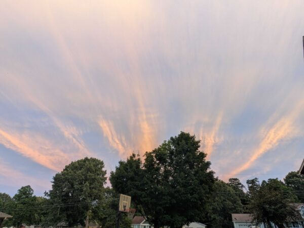
IMAGE OF THE DAY
Skywatcher Krista Hahn sent in amazing pictures of radial clouds over Huntsville yesterday evening. IT was difficult to choose one image of the day today, our Skywatchers sent in a ton of content yesterday and this morning. Thank y’all!



