


FINE FALL DAY: Temperatures are mostly in the mid 60s across North/Central Alabama this afternoon with a good supply of sunshine through high, thin cirrus clouds. The average high for Birmingham on October 17 is 75. Tonight will be clear and very cool with lows well down in the 40s; colder spots go back in the 30s again.

Tomorrow will be a mostly sunny day for the northern half of Alabama with a high in the low to mid 70s… but down south clouds invade South Alabama, with rain likely for the Gulf Coast by afternoon as a tropical system approaches.
PTC 16: “Potential Tropical Cyclone 16” is in the Gulf of Mexico, headed for the Florida Panhandle. It is expected to become a tropical depression or storm tonight, but it should remain well below hurricane strength due to harsh winds aloft. NHC has issued these advisories…
A Tropical Storm Warning is in effect for…
* Mississippi/Alabama border to the Ochlockonee River, Florida
* Grand Isle, Louisiana to the Mouth of the Pearl River
A Tropical Storm Watch is in effect for…
* East of the Ochlockonee River to Yankeetown, Florida
A Storm Surge Watch is in effect for…
* Indian Pass to Clearwater Beach, Florida
The system is expected to make landfall during the pre-dawn hours Saturday somewhere around Port St. Joe/Indian Pass/Apalachicola. If it becomes a tropical storm, the name will be “Nestor”.

THE ALABAMA IMPACT: Heaviest rain with the tropical system will be confined to far Southeast Alabama, where amounts to 2 inches are possible around Dothan. Otherwise, the best chance of rain Saturday will be over the eastern half of the state, along and east of I-65. Amounts over East Alabama should be generally 1/2 inch or less, and the higher rain amounts will be to the east over parts of Georgia and South Carolina.
Some patchy light rain over West Alabama can’t be ruled out, but many communities west of I-65 won’t see any rain at all Saturday. The high Saturday will be in the 60s over East Alabama, and close to 70 over the western counties of the state.
Sunday will be dry statewide… the sky will be partly sunny and the high will be in the 75-80 degree range.
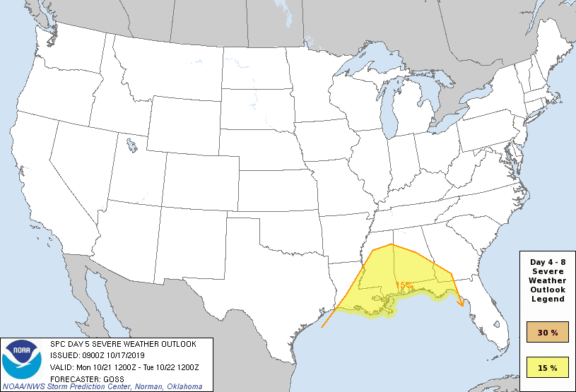
NEXT WEEK: A cold front will move into the state Monday night, and bring the threat of strong to severe thunderstorms. For now, it looks like the main threat will come from damaging straight line winds late Monday afternoon and Monday night. But, we need to get the tropical system out of here before we become too confident on the impact forecast for this system.
SPC has much of Central and South Alabama in a severe weather risk on their “Day Five” severe weather outlook for Monday/Monday night.
The middle of the week will be dry and pleasant, then another front will bring a chance of showers and storms by Thursday night and Friday (October 24-25)… See the Weather Xtreme video for maps, graphics, and more details.
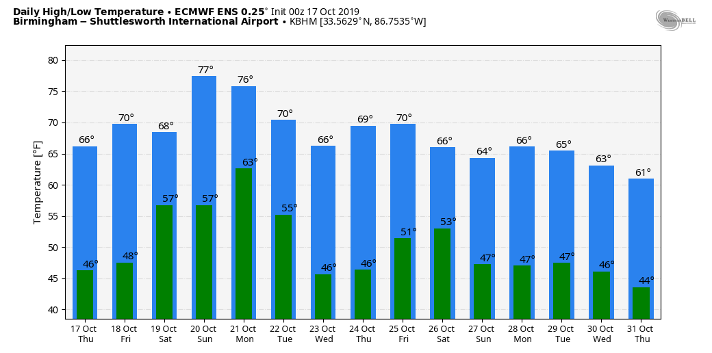
FOOTBALL WEATHER: For the high school games tomorrow night, dry weather is expected over the northern half of Alabama with temperatures in the 60s. But, to the south, rain is good possibility for the southern quarter of Alabama as the tropical low approaches.
Auburn travels to Fayetteville, Arkansas to take on the Razorbacks Saturday (11:00a CT kickoff)… showers and thunderstorms are possible during the first half of the game. The kickoff temperature will be close to 64 degrees, rising into the upper 60s by the final whistle.
Alabama will host Tennessee Saturday night at Bryant-Denny Stadium in Tuscaloosa (8:00p CT kickoff)… it now looks like the bulk of the rain will remain east of Tuscaloosa, and we are now forecasting dry conditions. Temperatures will be in the mid to upper 60s. A little light rain is possible during the day, before the game.
UAB hosts Old Dominion Saturday afternoon at Legion Field in Birmingham (3:00p CT kickoff)… the sky will be mostly cloudy, and some light rain is possible during the game. Kickoff temperature will be near 70 degrees, falling back into the upper 60s by the final whistle.
Jacksonville State hosts Southeast Missouri State Saturday (3:00p CT kickoff)… the sky will be mostly cloudy; rain is possible. Temperatures will fall from near 70 at kickoff, into the upper 60s by the fourth quarter.
ON THIS DATE IN 1910: A category 4 hurricane moved north-northeast, passing just east of the Dry Tortugas. The maximum storm surge observed in Key West was 8 feet, with 15-foot waves at what is now Fort Zachary Taylor State Park.
BEACH FORECAST: Click here to see the AlabamaWx Beach Forecast Center page.
WEATHER BRAINS: Don’t forget you can listen to our weekly 90 minute show anytime on your favorite podcast app. This is the show all about weather featuring many familiar voices, including our meteorologists here at ABC 33/40.
CONNECT: You can find me on all of the major social networks…
Facebook
Twitter
Instagram
Pinterest
Snapchat: spannwx
I had a great time today visiting with the students at Ivalee Elementary in Etowah County… be looking for them on the Pepsi KIDCAM today at 5:00 on ABC 33/40 News! The next Weather Xtreme video will be posted here by 7:00 a.m. tomorrow…



