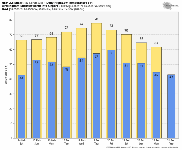
SUNNY: Again today we have a good supply of sunshine across Alabama with temperatures in the 62-72 degree range. Tonight will be mostly fair with a low generally in the 40s.

We will begin to see an increase in clouds across the state tomorrow ahead of an approaching storm system, but most of the day will be dry with only small, isolated showers. Temperatures reach the upper 60s and low 70s tomorrow afternoon.
SUNDAY: Rain returns to Alabama Sunday. Rain will push into the western counties before daybreak, spreading eastward during the day. While the most widespread rain will be east of Alabama by early afternoon, a few additional showers could form as an upper trough moves through. All of the rain should be gone by 9:00 p.m. Sunday.
Forecast rain amounts have come down; it now looks like most places will see 1/2 to 1 inch of rain Sunday.
There will be basically no surface based instability across Alabama, so severe storms are not expected. The possible exception would be Mobile and Baldwin counties where low CAPE values are possible, but the threat there is low with weakening dynamics.
NEXT WEEK: It will be the warmest week so far this year. Highs will be generally in the 70s, but some South Alabama communities could reach the low 80s by mid-week. Most of the week will be dry, although a few isolated showers could show up by Friday. See the video briefing for maps, graphics, and more details.
ON THIS DATE IN 1899: One of the coldest air masses ever observed in the U.S. made it all the way to the Gulf Coast. It was 7F in New Orleans and Pensacola. Mobile dropped to a numbing -1F. The reading of -2F at Tallahassee still is the state’s coldest reading ever.
Birmingham dropped to -10F… the coldest temperature on record for the city. At the time observations for Birmingham was taken at the old U.S. Weather Bureau office in Fountain Heights. Other Alabama lows that cold morning: -7F in Tuscaloosa, Elba and Opelika; -5 in Greensboro; -11 in Florence; -12 in Decatur; -15 in Oneonta; -16 in Hamilton and Scottsboro and –18 in Valley Head. Greensboro had five inches of snow on the ground.
ON THIS DATE IN 1952: An intense outbreak of 15 tornadoes struck the Southeast. An F3 tornado moved through parts of northern Tuscaloosa and eastern Fayette counties, killing one and injuring 14. Another F3 tornado near Adamsville killed one and injured 26. The worst event involved a violent F4 tornado in Tennessee that obliterated Beech Hill and heavily damaged Decherd, killing three and injuring 44. Overall, the outbreak killed five and injured 102.
Look for my next video briefing here by 6:00 a.m. Monday… enjoy the weekend!