


Daily Weather Briefing
Sunday, June 7, 2026
ALABAMA THIS MORNING
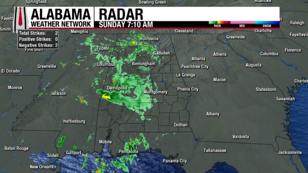
After a decent stretch of mostly quiet, dry mornings, widespread showers fall over parts of north, central, and south-central Alabama this morning. More specifically, showers stretch as far south as east of Evergreen, as far west as the Alabama-Mississippi state border, as far north as the Alabama-Tennessee state border, and as far east as Ohatchee. Clouds blanket the entire state regardless of rain, and temperatures sit in the low to mid 70s statewide. Dewpoints sit in the lower 70s, and it’s a humid morning if it’s not a rainy one.
ALABAMA 7 DAY FORECAST
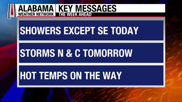
We enter a wetter pattern across most of the state except for southeast Alabama today through the week. Afternoon showers and thunderstorms will be the story this week, as well as temperatures and heat-index values increasing each day.
THUNDERSTORMS FOR SUNDAY
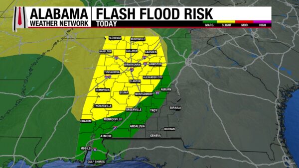
Scattered to widespread showers and thunderstorms will bring rain to most of the state throughout the day today. Storms will stay sub-severe, but the storms have access to a considerable amount of moisture, and they will be efficient rainfall producers. An elevated flash flood risk exists everywhere but in southeast Alabama. More on the rain threat in the Rainfall Outlook section below. While storms impact north, central, and most of south-central Alabama, the southeast will stay mostly dry due to an upper-level ridge near the area, encouraging sinking air instead of rising air, discouraging showers. A few showers may be able to form, but they will be isolated and quick-lived. The southwest will see showers, but mostly in the morning. A shower or two may linger in the afternoon, but it will be much drier compared to the northern two-thirds of the state. Highs will sit in the upper 70s and lower 80s in north and central Alabama, while south Alabama attempts to rise from the low 80s to the mid 80s.
RAINY NORTH, DRIER SOUTH TO START THE WEEK
This pattern of frequent thunderstorms continues tomorrow and Tuesday for the northern half of the state, while the southern half of the state stays comparatively drier.
Monday features a 70% chance of showers and thunderstorms in the southern half of the state. Storms will be slightly less widespread but will still be more than capable of bringing flash flood-causing rainfall. There is no severe threat associated with the storms. Highs will hit the low to mid 80s. In south Alabama on Monday, a few stray showers and rumbles of thunder are possible, but anything will be isolated. Highs will manage to climb into the mid to upper 80s as they won’t be inhibited by cooling showers.
A 70% chance of thunderstorms sticks around in the northern half of Alabama on Tuesday, and highs will hit the mid to upper 80s. A low 90-degree reading may sneak into the western counties as well. The southern half of the state will see an increase in shower activity as daytime heating provides plenty of reason for isolated to scattered showers to form. A 20% chance of storms will spread across the region, and highs will reach easily into the upper 80s and lower 90s.
WARMING TREND AND CONTINUED SHOWERS MID WEEK
Although rain chances in the northern half of the state fall to 50% by Wednesday, showers and thunderstorms will certainly still be prevalent in the afternoons. The southern half of the state will see continued isolated showers on Wednesday as well. Heat starts to become a concern as highs range from the upper 80s to lower 90s statewide, and feels-like temperatures begin to roam into the mid to upper 90s, and even 100 degrees.
Thursday may be the least rainy, as thunderstorm chances are only 30% in the northern half of Alabama and remain at 20% in the southern half. The warming trend will continue as highs will reach the lower 90s statewide, bringing feels-like temperatures to the upper 90s and 100 degrees.
HOT AND RAINY END TO THE WEEK
Afternoon storm chances rise to 50% across the northern half of the state and to 30% in the southern half on Friday. Highs remain in the low 90s, so the feels-like temperatures remain in the upper 90s to 100 degrees.
There is very little change in the forecast on Saturday.
As we start to see summer heat kick in, it is important to cool off often, seek shade often, and stay hydrated when spending long periods of time outside to avoid heat stress and illness.
RAINFALL OUTLOOK
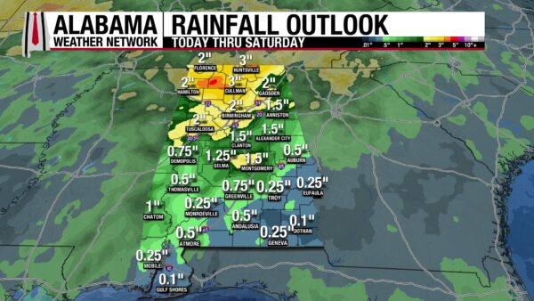
Since the rain’s focus is the northern half of the state, the region will see 1.5 to 3” of rain accumulate this week. In the southern half of the state, a quarter of an inch to an inch and a half of rain is possible. Today, a Slight Risk (2/4) for Excessive Rainfall is placed over most of Alabama, excluding southeast and southwest Alabama. Southwest and parts of southeast Alabama are under a Marginal Risk (¼) for Excessive Rainfall. These regions see an elevated risk of flash flooding today as storms will be efficient rainfall producers, and the ground is already saturated from May’s rain. A flash flood is dangerous; remember: Turn Around, Don’t Drown.
STILL ACTIVE PACIFIC AND QUIET ATLANTIC
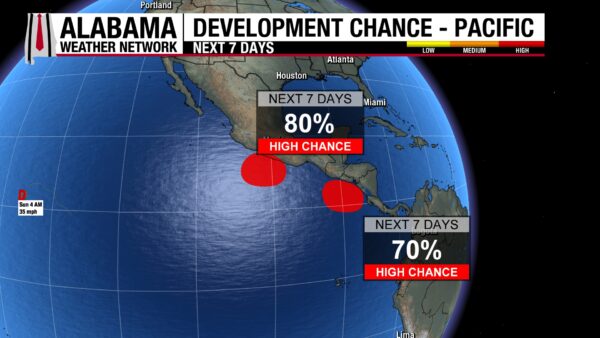
Amanda in the Pacific has weakened to a Tropical Depression, moving southwest at 3 mph with a sustained max wind speed of 35 mph. As this storm weakens, the two disturbances off the Pacific Coast of Central America strengthen. The more northern one has an 80% chance of development, and the southern one has a 70% chance of development. We are officially one week into the Atlantic Hurricane season, and the Gulf and Atlantic Ocean remain quiet.
CLEARING CONDITIONS ON THE COAST
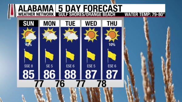
After a few days of poor weather on the coast, we see an improvement in the forecast. A 40% chance of showers is possible, but the higher chance of storms is for the morning. Then the skies will be partly sunny, the UV Index will be Very High, and the winds will be from the south at 10 mph. The high is in the mid-80s, so it will be warm but not too uncomfortable. The waters have calmed some as well, as there is a Moderate risk of rip currents instead of High (although it is still imperative to be careful while swimming).

WEATHERBRAINS 1064 – FLOOD INTELLIGENCE FOR SAFER COMMUNITIES
Tomorrow’s WeatherBrains episode features Brad Newman and Dr. Tracy Fanara, who will discuss Project ENKI, a flood intelligence project. Listen to the episode wherever you get your podcasts or watch it here.
HISTORY
June 7, 2023 – When the Sky Burned
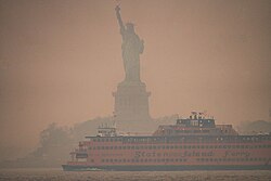
In the morning hours of June 7th, 2023, the eastern United States woke beneath a sky that felt unfamiliar and unsettling. Smoke from massive Canadian wildfires had poured southward into the Great Lakes, Northeast, and Mid-Atlantic, filtering the sun into a dim copper disk and turning skylines into shadows. In New York City, the Statue of Liberty, the bridges, and the towers of Manhattan faded behind an orange-brown haze that looked more like a distant disaster scene than a summer day in the nation’s largest city.
The smoke had traveled hundreds of miles from intense fires burning in Canada, especially across Quebec, where an unusually active early fire season sent huge plumes into the atmosphere. A stubborn weather pattern helped steer the smoke southward, allowing it to settle over some of the most densely populated parts of the United States. What began as a wildfire emergency far to the north became an air-quality crisis for millions of people who could smell the smoke, feel it in their throats, and see it swallowing familiar landmarks.
The numbers confirmed what people were experiencing outside their windows. June 7th became the worst wildfire-related smoke day in the United States since at least 2006, when comparable data began. Their estimate found that 61.8 million people were exposed to fine particle concentrations above 50 micrograms per cubic meter, a high level of PM2.5 exposure, and more than twice the number exposed on the previous record day in September 2020. In New York City, air quality levels reached historic extremes, and the smoky blanket disrupted flights, postponed ballgames, limited outdoor school activities, and sent many people searching for masks and air purifiers.
What made the day so memorable was not just the color of the sky, but the way it changed ordinary life without a tornado warning, hurricane advisory, or flash flood emergency. The hazard arrived silently, carried by the wind from fires hundreds of miles away. It was a powerful reminder that weather connects distant places, and that wildfire smoke can become a serious health threat far from the flames themselves.
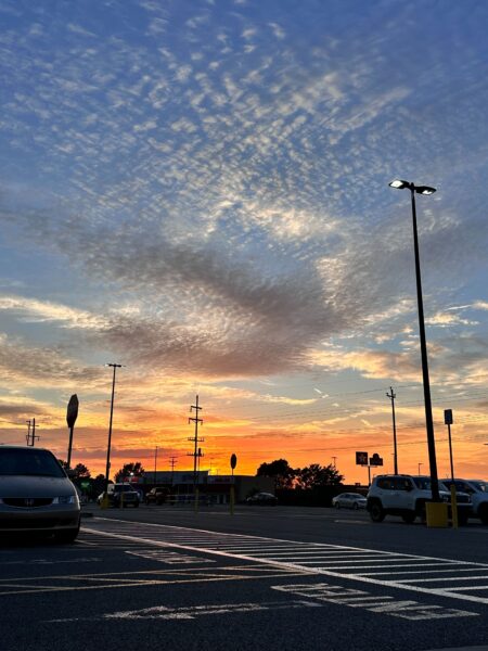
IMAGE OF THE DAY
Skywatcher CJ Twilley snapped this colorful photo of last night’s sunset over Cullman.



