


NOT A BAD SATURDAY FOR MOST
After a few lingering showers move out of the area around sunrise, much of the rest of Saturday will be dry across North/Central Alabama. Skies will remain partly to mostly cloudy across the area and highs will be in the upper 50s in the northwest to nearly touching 80 degrees in the southeast.
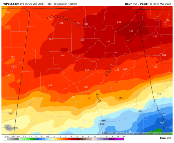
EXPECTED RAINFALL THROUGH MIDDAY FRIDAY
Rainfall from now through midday Friday looks to range from just over 1/2 inch in the extreme southeastern parts of the area to over 3-1/2 inches in the northeastern parts. The good news is that we have not had that much rainfall over the past week that has allowed the ground to dry out just a little, but we may have to watch for some localized flooding issues by Wednesday if this pans out.
RAIN RETURNS ON SUNDAY
Unfortunately, it looks like rain returns to the forecast on Sunday as rain chances increase from the southwest and south throughout the day. Rain will be likely at any time but it will not rain all day long. Some thunder will be possible, but nothing strong is expected. Highs reach the upper 50s to the mid-70s across North/Central Alabama from north to south.
RAIN POSSIBLE AT TIMES THROUGH MID-WEEK
Rain will continue to be likely at times across much of the area on Monday, but those rain chances will begin to fall for the northern half of the area by the evening and late-night hours. Once again, some thunder will be possible and I wouldn’t be surprised if we may see a strong storm or two, but the overall severe weather threat is really, really low. Highs will be back up into the mid-60s to the mid-70s across the area.
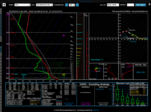
The active pattern continues on Tuesday as scattered showers and a few thunderstorms will be likely over the northern parts of the area while those rain chances drop rather quickly as you move south. At this point, there is a good chance that locations along and south of I-85 stay dry. Now we may have to watch for a few strong to marginally severe storms over the northern half of the area as it looks like we’ll have a good bit of instability in place along with a good bit of shear during the afternoon and evening hours. Strong winds look to be the main threat at this point, but we cannot rule out a brief tornado with this setup. We’ll keep an eye on this over the next few days to see what the convection-allowing models have to say. Highs will be in the lower 70s to the lower 80s across the area.
The good news is that much of the thunderstorm activity will be out of the area on Wednesday morning, but we could see a few isolated to scattered showers over the central and southern parts of the area, while North Alabama looks to get a chance to dry out. Highs will be in the lower 70s to the lower 80s.
MAINLY DRY & WARM TO END THE WORK WEEK
Thursday looks to be a mainly dry day across North/Central Alabama, but we could see an isolated shower or two over the northern parts of the area during the main heating of the day. A few showers may be possible during the evening to late night hours as well for the northern locations, but the rest of the night time hours look to stay dry. Highs will be in the upper 70s to the upper 80s across the area.
Friday looks to be another fantastic and warm day across much of the area, but rain and thunderstorms may invade the extreme northern portions of North Alabama during the afternoon and evening hours. The rest of the area stays dry and highs reach the mid-70s to the upper 80s.
BEACH FORECAST
Even though the beaches across the Alabama and Florida Gulf Coasts are closed, you may still want to know what the weather will be like. Get the latest weather and rip current forecasts for the beaches from Bay St. Louis, MS, to Panama City Beach, FL, on our Beach Forecast Center page. There, you can select the forecast of the region that you are interested in.
ADVERTISE ON THE BLOG!
We had another fantastic year in 2019 with just over 17 million page views! That brings our total for the last 2 years close to 37 million page views! Don’t miss out! We can customize a creative, flexible, and affordable package that will suit your organization’s needs. Contact Bill Murray at (205) 687-0782.
E-FORECAST
Get the Alabama Wx Weather Blog’s Seven-Day Forecast delivered directly to your inbox by email twice daily. It is the most detailed weather forecast available in Central Alabama. Subscribe here… It’s free!
CONNECT WITH THE BLOG ON SOCIAL MEDIA
You can find the AlabamaWx Weather Blog on the major social media networks:
Facebook
Twitter
Instagram
WEATHERBRAINS
Don’t forget you can listen to our weekly 90 minute netcast anytime on the web at WeatherBrains.com or on Apple Podcasts, Stitcher, or Spotify. This is the show all about weather featuring many familiar voices, including the meteorologists at ABC 33/40.



