POTENTIAL FOR SEVERE STORMS LATER THIS EVENING
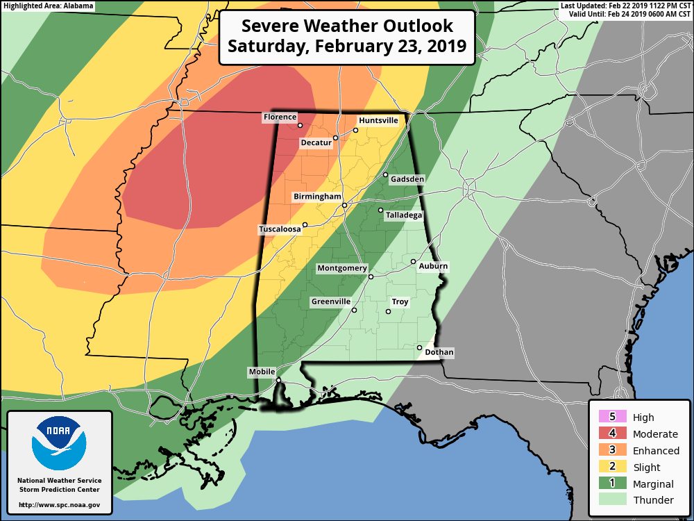
Strong to severe storms are expected across the southeast on Saturday, including damaging thunderstorm winds in excess of 60 MPH, large hail of 1 inch in diameter or more, and tornadoes (some of which could be large, long-track in nature). We could see those stronger to severe storms across much of Central Alabama later this evening and into the first few hours of Sunday.
The latest from the SPC has locations west of a line from Sulligent (Lamar Co.) to Hackleburg (Marion Co.) to Lexington (Lauderdale Co.) defined in a Moderate Risk of severe storms (level 4 of 5)for Saturday. Locations east of that to a line stretching from Geiger (Sumter Co.) to Jasper (Walker Co.) to Hazel Green (Madison Co.) defined in an Enhanced Risk (level 3 of 5). Locations east of that to a line stretching from Linden (Marengo Co.) to Pelham (Shelby Co.) to Ider (Dekalb Co.) defined in a Slight Risk (level 2 of 5). Locations east of that to a line stretching from Hayneville (Lowndes Co.) to Alexander City (Tallapoosa Co.) to just west of Ranburne (Cleburne Co.) defined in a Marginal Risk (level 1 of 5).
Timing of the stronger to severe storms will be from 5:00 pm to 10:00 pm in the Moderate and Enhanced Risk areas, 8:00 pm to 1:00 am in the Slight Risk area, and 11:00 pm to 3:00 am in the Marginal Risk area. Once the line of storms makes it east of the risk areas, the threat of severe storms should have come to an end.
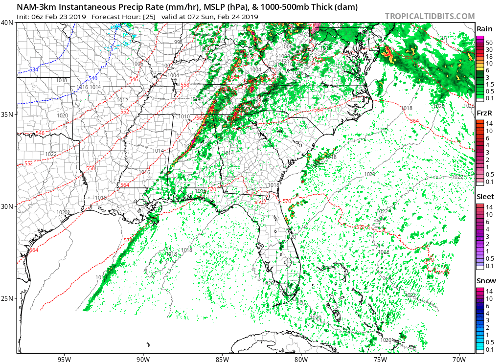
NAM Simulated Radar valid at 1:00 am Sunday.
The latest run of the high-resolution NAM is showing that the main line of storms will move into the northwestern parts of Central Alabama around 8:00 pm – 10:00 pm, but it is also showing a potential of a few cells developing out ahead of the line as early as 3:00 pm. The line will cross the western parts of the area and make it into the Birmingham metro and Tuscaloosa around 11:00 pm – 1:00 am, and into the Montgomery area around 2:00 am – 4:00 am.
Daytime highs will be in the lower 70s to the mid-80s across the area from north to south, with lows dipping down into the mid-40s to the lower 60s from northwest to southeast.
Not only will we have the potential for strong to severe storms, a tightening pressure gradient will cause gusty winds across the area without thunderstorms. Those could be strong enough to bring down a few trees, especially with the super-saturated soil. Rain could be heavy at times on Saturday as well, which could add to the flooding issues that are already occurring.
Go ahead and have your emergency plan and kit ready to go just in case your location goes under a warning. Also, have multiple ways to receive weather alerts.
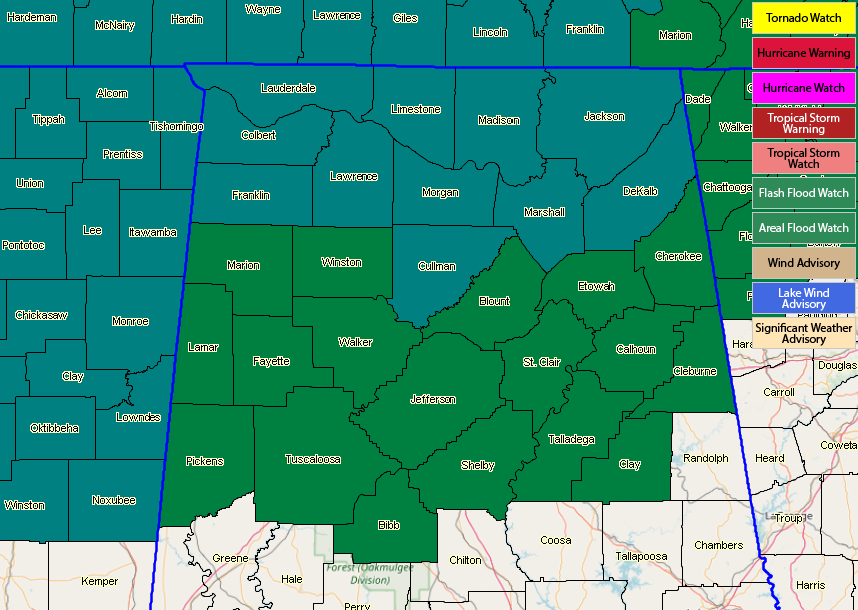
FLOOD WATCHES CONTINUE INTO SUNDAY
A Flash Flood Watch continues in effect for Colbert, Cullman, DeKalb, Franklin, Jackson, Lauderdale, Lawrence, Limestone, Madison, Marshall, and Morgan counties in North Alabama until 12:00 am Sunday.
An Areal Flood Watch continues in effect for Bibb, Blount, Calhoun, Cherokee, Clay, Cleburne, Etowah, Fayette, Jefferson, Lamar, Marion, Pickens, Shelby, St. Clair, Talladega, Tuscaloosa, Walker, and Winston counties in Central Alabama until 6:00 am Sunday.
A MUCH IMPROVED DAY ON SUNDAY WITH COOLER TEMPERATURES
Storms will be exiting the area just after sunrise and skies will quickly be clearing out behind the front. We’ll have sunny skies by the afternoon and highs will be topping out in the upper 50s to the upper 60s across the area from northwest to southeast.
NEXT WEEK
We’ll have a ton of sunshine throughout the day on Monday with highs reaching the upper 50s to the mid-60s. We’ll start off the day on Tuesday with mostly sunny skies, but clouds will begin to move in late along with a small chance of scattered showers. Highs will be in the 60s. Unfortunately, it looks like shower chances will continue to be in the forecast to end out the work week, with scattered showers possible on each day. Wednesday’s highs will be in the lower 60s to the lower 70s, Thursday’s highs in the upper 50s to the lower 70s, and Friday’s highs in the upper 50s to the upper 60s.
ON THIS DAY IN WEATHER HISTORY
1936 – A severe blizzard in the Sierra Nevada Range closed Donner Pass. It stranded 750 motorists and claimed seven lives.
BEACH FORECAST CENTER
Get the latest weather and rip current forecasts for the beaches from Fort Morgan to Panama City on our Beach Forecast Center page. There, you can select the forecast of the region that you are interested in.
ALREADY OFF TO A HOT START IN 2019! ADVERTISE WITH THE BLOG!
We have enjoyed over 3.2 MILLION page views on AlabamaWx.com so far in 2019! Don’t miss out! We can customize a creative, flexible and affordable package that will suit your organization’s needs. Contact Bill Murray at (205) 687-0782.
CONNECT WITH THE BLOG ON SOCIAL MEDIA
You can find the AlabamaWx Weather Blog on the major social media networks:
Facebook
Twitter