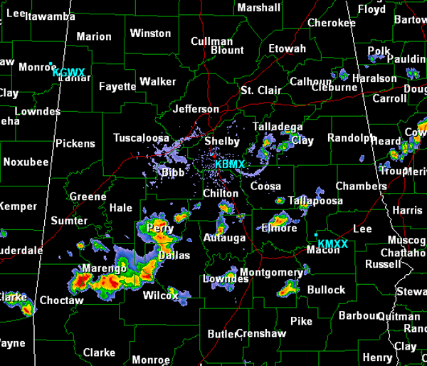
Depending where you are across North Central Alabama, the weather is quite different. Areas along and north of Interstate 20 are seeing mostly sunny skies. To the south, scattered showers and thunderstorms. These storms are widely scattered but are a bit more concentrated along the U.S. Highway 80 corridor from Marengo County to Dallas County. Storms are approaching the Selma area and could be producing gusty winds and some small hail. All storms are producing intense rain and frequent lightning. There are intense storms impacting portions of Elmore, Autauga, Montgomery Counties as well. All activity will continue to move to the east/southeast through out this afternoon.
Published on: June 29, 2013 at 3:06 PM
Related Articles
October 30, 2026 at 3:02 PM
Some Rain At Times Over The Weekend
WARM AFTERNOON: Temperatures are between 77 and 82 degrees across Alabama this afternoon with sun through high cirrus clouds. No rain on radar. Clouds will increase tonight. We will mention a chance of showers statewide over the weekend. A few … Continue reading →
READ MORE
October 30, 2026 at 5:36 AM
Showers Return Over The Weekend
ONE MORE DRY DAY: For most of Alabama today will be the 19th consecutive day with no measurable rain. Expect a partly sunny sky with a high close to 80 degrees this afternoon. SHOWERS RETURN: Moisture levels will rise tonight, … Continue reading →
READ MORE

