


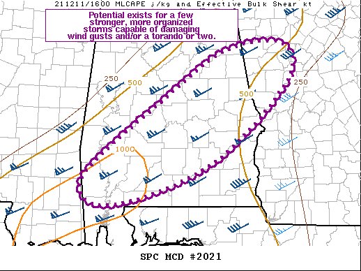
With the cold front moving through the I-59 corridor, the west and northern parts of the area has been cleared of any threat of severe storms. However, the potential continues for locations along and ahead of the line of storms, especially the southern and southeastern parts of Central Alabama. Air is becoming more unstable and the coverage of rogue cells out ahead of the main squall line will increase throughout the main heating of the day. A few damaging wind gusts and one or two tornadoes may be possible. A severe storm watch has a 40% chance of being issued. Here is the latest from the SPC:
SUMMARY… Potential exists from southwest AL into west-central GA for a few stronger, more organized storms capable of damaging wind gusts and/or a tornado or two.
DISCUSSION… Recent surface analysis places a well-defined cold front from near RMG in northwest GA back southwestward across central AL and southeast MS into eastern LA. Thunderstorms are ongoing along this front from northwest GA into central AL, with recent radar and satellite imagery also showing increasing pre-frontal showers and thunderstorms from southern MS into southern AL and the far western FL Panhandle. Modest buoyancy exists within the pre-frontal corridor from southern MS into northwest/northern GA and recent satellite imagery shows an increasingly agitated cumulus field. Consequently, the current trend of increasing pre-frontal storm coverage is likely to continue as broad ascent persists. Relatively warm mid-level temperatures will likely limit updraft depth and duration, evidenced by the limited lightning within the pre-frontal development thus far. Even so, strong southwesterly flow aloft atop slightly more southerly low-level flow results in both strong deep-layer vertical shear as well as robust low-level helicity. These environmental factors suggest that updraft organization is possible within any storms that are able to mature/persist, with damaging wind gusts and/or a tornado or two possible.



