


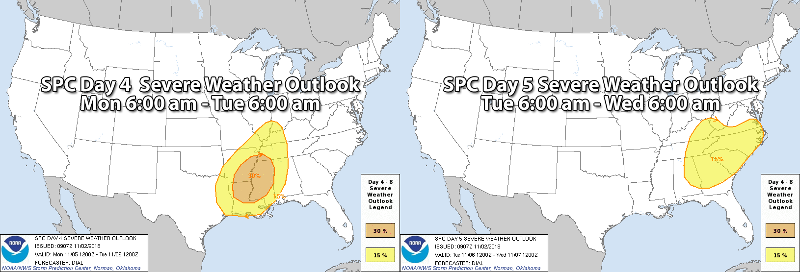
As our Fall Severe Weather Season officially kicked off on Thursday with strong to severe storms moving through North and Central Alabama, this is a reminder that we have to watch each approaching storm system for the threat of severe storms. Our next major storm system is forecast to move across the area on late Monday into Tuesday morning with all modes of severe weather possible: damaging winds, large hail, and tornadoes.
The above images show the day 4 and day 5 Severe Weather Outlooks from the Storm Prediction Center. Severe storms are likely to develop along a cold front that looks to push into North and Central Alabama late on Monday night and exits the area by the early afternoon hours on Tuesday. Shear and instability values, along with a strong upper jet, will be sufficient enough for the threat of damaging winds, tornadoes, and large hail.
From the NWS Birmingham’s Area Forecast Discussion earlier this morning…
A shortwave moving through the area on Sunday night will serve as a primer wave for the next system developing to our west on Monday. A wide area of rich moisture will be lurking near the Gulf Coast, poised to move inland Monday afternoon and evening as wind fields respond to a shortwave entering the southern Plains.
Models are coming into agreement on a potentially dangerous setup Monday night into Tuesday morning across a large area which includes Alabama. The GFS and ECMWF (European) are in good agreement with the evolution of the synoptic pattern, showing a low-amplitude shortwave taking on a negative tilt Monday night to our northwest. This pattern has the look of a classic severe weather outbreak and would support a rapidly deepening surface low tracking toward the Great Lakes with significant pressure falls extending southward into Alabama. With dewpoints rising into the upper 60s to perhaps 70F, instability appears more than sufficient for deep convection within a very highly sheared environment. Taken at face value, the ECMWF shows semi-discrete supercells capable of producing long-track, significant tornadoes across the northern half of our forecast area on Tuesday morning. The Hazardous Weather Outlook will be updated to include a moderate confidence threat for tornadoes and damaging winds across the entire forecast area. With this threat still around 96 hours out and models subject to change, we will refrain from going all in on the potential for a tornado outbreak.
Earlier this year, we put up a few posts for Severe Weather Awareness Week. Now would be a good time to brush up on the information given. Here are the links to those posts:
Severe Thunderstorms
Tornadoes
Lightning
Receiving Weather Alerts
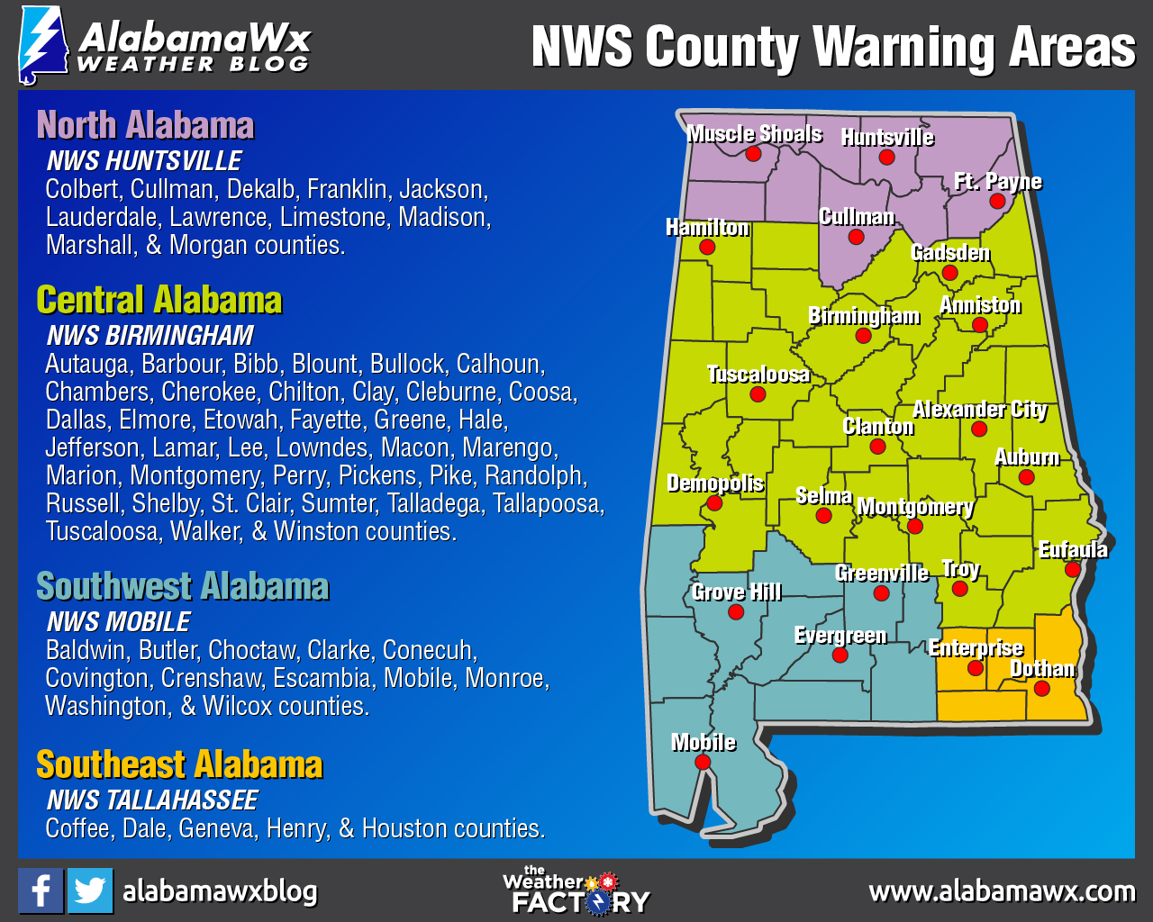
There are four National Weather Service offices that serve the state of Alabama. If you are not sure which office serves your community, now is a great time to learn. Here are the counties served by each office:
NWS Huntsville (North Alabama): Colbert, Cullman, Dekalb, Franklin, Jackson, Lauderdale, Lawrence, Limestone, Madison, Marshall, and Morgan.
NWS Birmingham (Central Alabama): Autauga, Barbour, Bibb, Blount, Bullock, Calhoun, Chambers, Cherokee, Chilton, Clay, Cleburne, Coosa, Dallas, Elmore, Etowah, Fayette, Greene, Hale, Jefferson, Lamar, Lee, Lowndes, Macon, Marengo, Marion, Montgomery, Perry, Pickens, Pike, Randolph, Russell, Shelby, St. Clair, Sumter, Talladega, Tallapoosa, Tuscaloosa, Walker, and Winston.
NWS Mobile (Southwest Alabama): Baldwin, Butler, Choctaw, Clarke, Conecuh, Covington, Crenshaw, Escambia, Mobile, Monroe, Washington, and Wilcox.
NWS Tallahassee (Southeast Alabama): Coffee, Dale, Geneva, Henry, and Houston.
If you are not sure which NOAA WeatherRadio frequency covers your community, here is the link to the NOAA WeatherRadio County Coverage Listing For Alabama page.
If you are wondering, “Will this be like April 27, 2011?” That is not a good question. A day like April 27th happens usually once in a generation (approximately every 40 years). As James Spann says… “All it takes is just one tornado in the state, and if that tornado comes down your street, then it is your April 27th.” We have to be ready for every severe weather threat.
Be ahead of the weather… have fresh batteries in your NOAA WeatherRadio and in your flashlights… have a designated safe place ready to go… have a readiness kit in your safe place (includes helmets for everyone, hard-soled shoes, and portable airhorns)… have your smartphones fully charged before the storms arrive in your neighborhood.
We’ll have updates on the blog today and through the weekend on this developing weather situation.



