


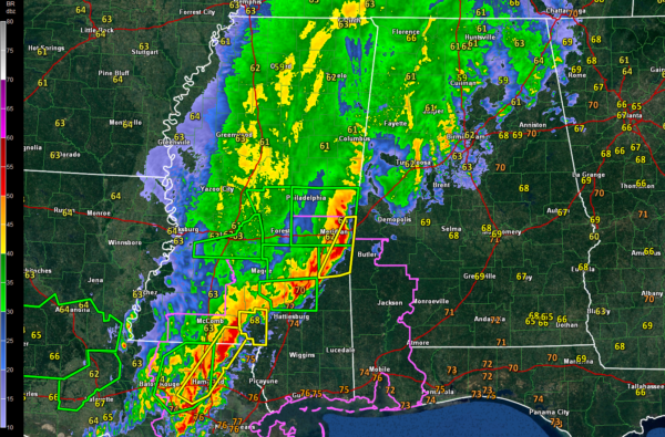
A line of intense thunderstorms continues to push east early this morning across Southeast Mississippi. It extends from the Meridian area southwestward through Laurel, Columbia and into Louisiana near Hammond.
Several severe thunderstorm warnings are in effect, including one for the Meridian area.
There are also numerous flash flood and flood warnings across Southern Mississippi and SE Louisiana.
A tornado watch is in effect for SE Louisiana, southern Mississippi and Southwest Alabama. In Alabama, the watch only includes counties in the Mobile NWS warning area (as far north as Choctaw and Clarke).
There were a couple of tornado warnings in Southeastern Louisiana and southern Mississippi a little earlier, but no reports of any tornadoes with them.
There were a few wind damage reports across southern Mississippi up until a little past 2 a.m., but those have died down.
Still, the line of storms seems to be becoming more intense. The threat of damaging winds and a few tornadoes continues for areas south of a line from Linden to Selma to Lafayette.
To the north, a large area of rain with some embedded thunder continues along and north of the I-59 Corridor. Strong storms will impact Sumter, Greene, Hale and northern Marengo Counties shortly. A severe thunderstorm warning could be needed for Sumter County.
A good bit of lightning continues from eastern Walker through northwestern Jefferson into Tuscaloosa County. The strongest storms in North Central Alabama are over southern Cullman and northern Tuscaloosa Counties.



