



UPDATE: This storm is likely producing large, destructive hail. Use extreme caution with this storm.
Hail and damaging winds are likely with this storms that is impacting central Winston County. U.S. 278, Double Springs, and Arley are in the path of this storm. Along with winds and hail, expect dangerous lightning and torrential rainfall. This storm is tracking off towards the east-southeast.
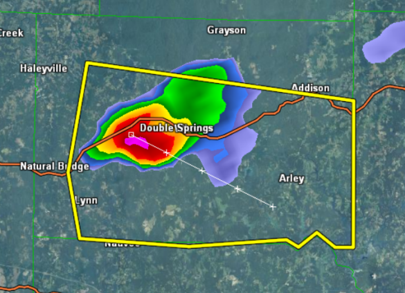
THE NATIONAL WEATHER SERVICE IN BIRMINGHAM HAS ISSUED A
* SEVERE THUNDERSTORM WARNING FOR…
WINSTON COUNTY IN NORTHWEST ALABAMA…
* UNTIL 830 PM CDT
* AT 736 PM CDT…THE NATIONAL WEATHER SERVICE INDICATED A SEVERE
THUNDERSTORM CAPABLE OF PRODUCING QUARTER SIZE HAIL…AND DAMAGING
WINDS IN EXCESS OF 60 MPH. THIS STORM WAS LOCATED NEAR WINSTON
FREE STATE BARN…OR 7 MILES NORTHEAST OF LYNN…AND MOVING EAST AT
10 MPH.
* LOCATIONS IMPACTED INCLUDE…
ARLEY…ASHBANK…WINSTON FREE STATE BARN…DOUBLE SPRINGS…
HOUSTON RECREATIONAL AREA…POPLAR SPRINGS…MCDOWELL CAMP GROUNDS
AND CORINTH REC AREA.
PRECAUTIONARY/PREPAREDNESS ACTIONS…
FOR YOUR PROTECTION…MOVE TO AN INTERIOR ROOM ON THE LOWEST FLOOR OF
YOUR HOME OR BUSINESS.
TORRENTIAL RAINFALL IS ALSO OCCURRING WITH THIS STORM…AND MAY LEAD
TO FLASH FLOODING. DO NOT DRIVE YOUR VEHICLE THROUGH FLOODED
ROADWAYS.



