



A very dangerous storms is moving from Winston County into Walker County near the Smith Lake Dam. This storm has a history of producing large hail and is capable of damaging winds. This storms is just to the north of Interstate 22 and is affecting Sipsey, Curry, and the northern portions of Sumiton.
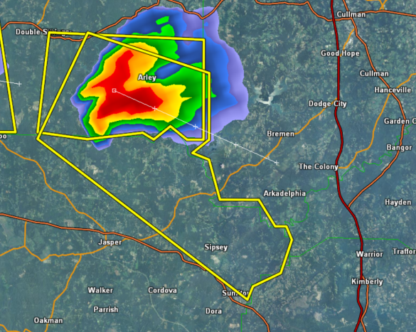
THE NATIONAL WEATHER SERVICE IN BIRMINGHAM HAS ISSUED A
* SEVERE THUNDERSTORM WARNING FOR…
NORTHEASTERN WALKER COUNTY IN ALABAMA…
SOUTHEASTERN WINSTON COUNTY IN NORTHWEST ALABAMA…
* UNTIL 915 PM CDT
* AT 824 PM CDT…THE NATIONAL WEATHER SERVICE INDICATED A SEVERE
THUNDERSTORM CAPABLE OF PRODUCING QUARTER SIZE HAIL…AND DAMAGING
WINDS IN EXCESS OF 60 MPH. THIS STORM WAS LOCATED NEAR FALLS
CITY…OR 5 MILES SOUTHWEST OF ARLEY…AND MOVING SOUTHEAST AT 15
MPH.
* LOCATIONS IMPACTED INCLUDE…
ARLEY…FALLS CITY…LAKE SHORE…CURRY…SMITH DAM…SIPSEY…
MANCHESTER AND WILSON BEND.
PRECAUTIONARY/PREPAREDNESS ACTIONS…
FOR YOUR PROTECTION…MOVE TO AN INTERIOR ROOM ON THE LOWEST FLOOR OF
YOUR HOME OR BUSINESS.
TORRENTIAL RAINFALL IS ALSO OCCURRING WITH THIS STORM…AND MAY LEAD
TO FLASH FLOODING. DO NOT DRIVE YOUR VEHICLE THROUGH FLOODED
ROADWAYS.



