



A cluster of very dangerous storms is moving into the Birmingham Metro. These storms will be impacting downtown Birmingham, as well as the Over the Mountain Communities of Hoover, Homewood, and Vestavia Hills. Large hail and damaging winds are the greatest threat. All major roadways around the city will be impacted including Interstates 20, 22, 59, 65. and 459.
Along with the severe threat, these storms are producing tremendous amounts of lightning as well as very heavy rainfall, that could produce flash flooding. This cluster of storms is moving towards the east-southeast.
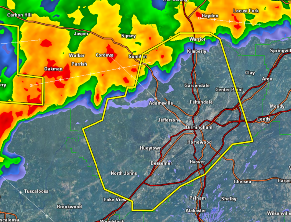
THE NATIONAL WEATHER SERVICE IN BIRMINGHAM HAS ISSUED A
* SEVERE THUNDERSTORM WARNING FOR…
JEFFERSON COUNTY IN ALABAMA…
* UNTIL 1115 PM CDT
* AT 1006 PM CDT…THE NATIONAL WEATHER SERVICE INDICATED A LINE OF
SEVERE THUNDERSTORMS CAPABLE OF PRODUCING QUARTER SIZE HAIL…AND
DAMAGING WINDS IN EXCESS OF 60 MPH. THESE STORMS WERE LOCATED
ALONG A LINE EXTENDING FROM KIMBERLY TO GRAYSVILLE TO GORGAS STEAM
PLANT…AND MOVING SOUTH AT 30 MPH.
* LOCATIONS IMPACTED INCLUDE…
GARDENDALE…FULTONDALE…FAIRFIELD…HUEYTOWN…BIRMINGHAM…
HOMEWOOD…IRONDALE AND BESSEMER.
THIS INCLUDES…
INTERSTATE 65 EXIT NUMBERS 250 THROUGH 282…
INTERSTATE 459 EXIT NUMBERS 1 THROUGH 33…
US 78 EXIT NUMBERS 81 THROUGH 91…
INTERSTATE 20 EXIT NUMBERS 104 THROUGH 136…
INTERSTATE 59 EXIT NUMBERS 130 THROUGH 137…
PRECAUTIONARY/PREPAREDNESS ACTIONS…
FOR YOUR PROTECTION…MOVE TO AN INTERIOR ROOM ON THE LOWEST FLOOR OF
YOUR HOME OR BUSINESS.
TORRENTIAL RAINFALL IS ALSO OCCURRING WITH THESE STORMS…AND MAY
LEAD TO FLASH FLOODING. DO NOT DRIVE YOUR VEHICLE THROUGH FLOODED
ROADWAYS.



